
Kolhapur is a city on the banks of the Panchganga River in the southern part of the Indian state of Maharashtra.

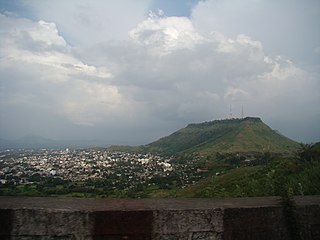
Panhala is a city and a Hill station Municipal Council 18 km northwest of Kolhapur, in Kolhapur district in the Indian state of Maharashtra. Panhala is the smallest city in Maharashtra and being a Municipal Council the city is developing rapidly. The city sprawls in the Panhala fort commands a panoramic view of the valley below. The main historical attraction here is the Panhala fort. There are many places of interest, each with its share of haunting anecdotes.
Satara is a city located in the Satara District of Maharashtra state of India, near the confluence of the river Krishna and its tributary, the Venna. The city was established in the 16th century and was the seat of the Chhatrapati of the Maratha Kingdom, Shahu I.

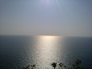
Ganpatipule is a coastal town in Ratnagiri district of Maharashtra. Due to its Ganpati mandir the town is popular Hindu pilgrimage and tourists destination.

Bhavani Mandap is a historical building situated in the walled city center of Kolhapur in southern Maharashtra, India. It is located near the famous and mammoth Mahalaxmi Temple on the west.

Sangli district is a district of Maharashtra state in India. Sangli city is the district headquarters. It is bordered by Satara district, Solapur district to the North, Karnataka state to the South-East, by Kolhapur district to South-West and by narrow portion on the East side to Ratnagiri district. It is present on the southern tip of Maharashtra.

Karad is a town in Satara district of Indian state of Maharashtra. It is located 302 km (180.19 miles) from Mumbai, 74 km from Sangli and 162 km from Pune. It lies at the confluence of Koyna River and the Krishna River known as the "Pritisangam". The two rivers originate at Mahabaleshwar, which is around 100 km from Karad. Karad is well known for sugar production and is known as the sugar bowl of Maharashtra owing to the presence of many sugar factories in and around Karad. It is considered an important educational hub in Western Maharashtra due to the presence of many prestigious educational institutes. Karad is resting place of the first chief minister of Maharashtra Yashwantrao Chavan situated at the confluence of the Krishna and Koyana rivers. It is ranked as the cleanest town in Swachh Survekshan 2020 in the category of population with less than 1 lakh.
Kodoli is a census town in Kolhapur district in the Indian state of Maharashtra. It is situated between the foothills of Panhala fort (Ranges) and Warana River. Kodoli is well developed town as per all point of view. Kodoli is home to many and variety of industries. This is one of the unique towns in the Maharashtra where you can get glimpse of modernity and heritage at one place e.g. town still inherits open air theaters. Kodoli is the biggest city in Panhala tehsil.
Sudhagad / Bhorapgad is a hill fort situated in Maharashtra, India. It lies about 53 kilometres (33 mi) west of Pune, 26 kilometres (16 mi) south of Lonavla and 11 kilometres (6.8 mi) east of Pali in Raigad District. The summit is 620 metres (2,030 ft) above sea level. The entire area around the fort is declared a Sudhagad wildlife sanctuary.
The Battle of Pavan Khind ; was a rearguard last stand that took place on 13 July 1660, at a mountain pass in the vicinity of fort Vishalgad, near the city of Kolhapur by the Maratha general Baji Prabhu Deshpande and Shambhu Singh Jadhav against Siddi Masud of the Bijapur Sultanate. The engagement ended with the destruction of the Maratha forces, and a tactical victory for the Bijapur Sultanate that failed to achieve a strategic victory.

Gaganbawada is a town situated in the district of Kolhapur in Maharashtra, India. It is located 55 km by road from Kankavli. It is one of the taluka headquarters in Kolhapur district.
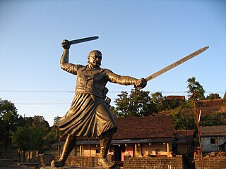
Paargad Fort is situated to the south of Kolhapur in Maharashtra state in India, at a distance of around 28;km from Chandgad. One of the major attractions of this fort is its serene environment and lush green surroundings. Apart from this, it is also known for housing a wonderful bronze statue of Chatrapati Shivaji and a temple of Bhagawati Bhawani.
Prachitgad is a fort in the Sahyadri mountain range in Sangli district of Maharashtra state, India. It covers an area of 5 acres (20,000 m2).

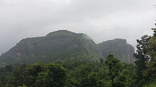
Amba Ghat is a mountain pass on Ratnagiri-Kolhapur road in Maharashtra, India, at a height of 2000 ft above sea-level, This ghat lies in the Sahyadri mountain ranges and has picturesque mountain-scapes and a pleasant climate. It is situated near Shahuwadi, Kolhapur district, and has nearby interesting places are Pawankhind and Vishalgad fort. It is a convenient weekend destination for Kolhapur tourists.

Gadhinglaj is a taluka in Maharashtra. The city of Gadhinglaj is the taluka headquarters and Gadhinglaj subdivision headquarters as well. As of 2011, the taluka had a population of 874,015, of which 35% were urban. Languages spoken in this area are Marathi, Kannada, Hindi and English also. But the most-spoken language is Marathi, as Marathi is a state language.
Mangad Fort is a survey fort which is situated in Borwadi, an area near Mashidwadi in Mangaon, a taluka in Raigad district in the Indian state of Maharashtra. The fort is made sacred by the footsteps of the founder of Hindavi Swaraj, the famous Maratha king Chhatrapati Shivaji Maharaja. Mangaon is situated about 150 km from Mumbai.
Patgaon is a village in Bhudargad Taluka of Kolhapur District, Maharashtra state in western India.The latitude 16.1253483"N and longitude 73.9459679"E are the geographical co-ordinates of Patgaon.

Shivgad Fort is a fort located 89km from Kolhapur, in Kolhapur district, of Maharashtra. This fort was an important fort in Kolhapur district as a watch over for the Phonda ghat trade route from Kolhapur to coastal ports. The fort is surrounded by thick forest and hill slopes.
Bhagwantgad Fort is a fort located 18 km from Malvan, in Sindhudurg district, of Maharashtra. This fort is located on the northern bank of Gad river or Kalaval creek. The fort is spread over an area of 1.5 acres and covered with dense vegetation.
Nivati Fort is a fort located 10 km south of Malvan in Sindhudurg district, of Maharashtra. This fort is located on the hill near the Nivati village. The fort is spread over an area of 4-5 acres and covered with dense bushes.