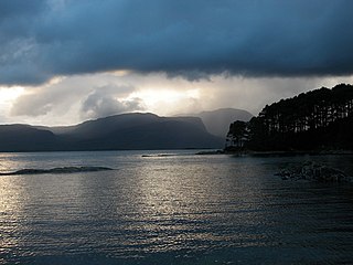
Loch Gairloch, from above Gairloch Harbour. The summits of Beinn Alligin in Torridon are in the distance.
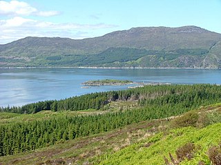
The Gair Loch is a sea loch on the North West coast of Highland, Scotland. In Scottish Gaelic it is an Geàrr Loch meaning 'the short loch'. Around 6 miles (9.7km) long by 1.5 miles (2.4km) wide, it leads west to the Little Minch. The B8021 and B8056 run around its northern and southern shores respectively, connecting the villages of Gairloch, Charlestown, Kerrysdale, Shieldaig, Badachro, and Port Henderson. Longa Island lies at the loch's entrance.
The Loch has a number of small islands in it, Eilean Horrisdale supported a fishing community in the 19th century.
The Great Glen, also known as Glen Albyn or Glen More, is a glen in Scotland running for 62 miles (100 km) from Inverness on the edge of the Moray Firth, in an approximately straight line to Fort William at the head of Loch Linnhe. It follows a geological fault known as the Great Glen Fault, and bisects the Scottish Highlands into the Grampian Mountains to the southeast and the Northwest Highlands to the northwest.
Loch Seaforth is a sea loch in the Outer Hebrides of Scotland. It consists of three distinct sections; the most seaward is aligned northwest–southeast, a middle section is aligned northeast–southwest and the inner and most northerly section is aligned east–west. The southern stretch of the loch seaward from Bowglass forms the boundary between Lewis and Harris and was until 1975 the boundary between the traditional counties of Ross and Cromarty and Inverness-shire. The settlement of Rhenigidale lies near the mouth of the loch whilst the settlement of Maaruig lies on Loch Maraig, an embayment on the western side of Loch Seaforth. Further settlement is found around the small bays at Ardvourlie opposite Seaforth Island which sits in the midst of the loch at the point where inland it turns towards the northeast. The crofting township of Arivruaich lies beside a further embayment known as Tob Cheann Tarabhaigh. The head of the loch is to be found 5 km further east at Ceann Shiphoirt. The loch forms the entire western coast of the relatively isolated Pairc peninsula.
Gogarloch is a residential area within South Gyle, Edinburgh, Scotland. It lies near South Gyle railway station and South Gyle Broadway, 4+1⁄2 miles (7.2 km) west of the city centre. Corstorphine and Wester Broom are nearby.
The Isle of Ewe is a small Scottish island on the west coast of Ross and Cromarty. The island is inhabited by a single extended family, the Grants, who have lived at the current settlement on the leeward NE side of the island since the 19th century.
Loch Carron is a sea loch on the west coast of Ross and Cromarty in the Scottish Highlands, which separates the Lochalsh peninsula from the Applecross peninsula, and from the Stromeferry headland east of Loch Kishorn. It is the point at which the River Carron enters the North Atlantic Ocean.
Loch Hourn is a sea loch which separates the peninsulas of Glenelg to the north and Knoydart to the south, on the west coast of Scotland.
Loch Bracadale is a sea loch on the west coast of Skye in Scotland. It separates the Minginish Peninsula in the south from the Duirinish Peninsula in the north.
Longa Island is a small uninhabited island at the mouth of Loch Gairloch, on the west coast of Scotland. Longa is nearly one mile in length with an area of 126 hectares and a maximum elevation of 70 metres (230 ft) above sea level.
Ceann Ear is the largest island in the Monach or Heisgeir group off North Uist in north west Scotland. It is 203 hectares in size and connected by sandbanks to Ceann Iar via Sibhinis at low tide. It is said that it was at one time possible to walk all the way to Baleshare, and on to North Uist, 5 miles away at low tide. In the 16th century, a large tidal wave was said to have washed this away.
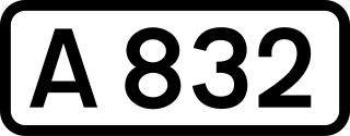
The A832 is a road in the Scottish Highlands, linking Cromarty, on the east coast, to Gairloch on the west coast, and beyond Gairloch to Braemore Junction. It is 126 miles (203 km) long and runs entirely in the former county of Ross and Cromarty. The road forms part of the Wester Ross Coastal Trail.
Eilean Sùbhainn is the largest of several small islands in Loch Maree, Wester Ross, Scotland. It is the second largest freshwater island in Scotland after Inchmurrin.
Loch Ness is a large freshwater loch in the Scottish Highlands extending for approximately 37 kilometres southwest of Inverness. It takes its name from the River Ness, which flows from the northern end. Loch Ness is best known for claimed sightings of the cryptozoological Loch Ness Monster, also known affectionately as "Nessie". It is one of a series of interconnected, murky bodies of water in Scotland; its water visibility is exceptionally low due to the high peat content of the surrounding soil. The southern end connects to Loch Oich by the River Oich and a section of the Caledonian Canal. The northern end connects to Loch Dochfour via the River Ness, which then ultimately leads to the North Sea via the Moray Firth.
Duirinish is a peninsula and civil parish on the island of Skye in Scotland. It is situated in the north west between Loch Dunvegan and Loch Bracadale.
Harlosh Island is one of four islands to be found in Skye's Loch Bracadale. Harlosh Island is one mile from the coast of the Duirinish Peninsula and four miles from the coast of the Minginish peninsula. At low tide it is only about 100 metres (330 ft) from Harlosh Point on mainland Skye.
Tarner Island is a triangular shaped island in Loch Bracadale just off the coast off the Harlosh peninsula of Skye in Scotland. It is about 28 hectares in extent and is 0.65 miles at its longest by 0.33 miles at its widest
The Sound of Sleat is a narrow sea channel off the western coast of Scotland. It divides the Sleat peninsula on the south-east side of the Isle of Skye from Morar, Knoydart and Glenelg on the Scottish mainland.
Gruinard Bay is a large remote coastal embayment, located 12 miles north of Poolewe, in northwestern Ross and Cromarty, and is in the former parish of Lochbroom, in the west coast of Scotland.
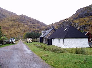
Kinloch Hourn is a small settlement at the end of Loch Hourn, in the West Highlands of Scotland. The name comes from the Gaelic, Ceann Loch Shubhairne, for "the head of Loch Hourn". Kinloch Hourn is at the end of 35 km of single-track road, which runs west from a junction with the A87 beside Loch Garry.
Loch Moidart is a sea loch in the district of Moidart in the Scottish Highlands. It is on the west coast of Scotland, and runs about 8 km eastward from the sea. It is connected to the sea by two narrow channels which are separated by the island of Eilean Shona, which in turn is nearly split in two by a narrow isthmus. The River Moidart enters the loch at its head, near the hamlet of Ardmolich. Various views of the loch have featured as an Apple TV screensaver since 2021.
Loch Gair Hydro-Electric Scheme is a small-scale hydro-electric power station, built by the North of Scotland Hydro-Electric Board and commissioned in 1956. It is located near Lochgair, a hamlet to the north-east of Lochgilphead, Argyll and Bute in Scotland. It was originally designed to supply power to Lochgilphead and the surrounding communities, but is now connected to the National Grid.
This page is based on this Wikipedia article Text is available under the CC BY-SA 4.0 license; additional terms may apply. Images, videos and audio are available under their respective licenses.