
(by Pieter Feddes van Harlingen).

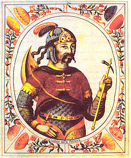
Gale Hania (died 1380) was the thirteenth potestaat (or ruler) of Friesland, a province of Netherlands.
Gale Hania (died 1380) was the thirteenth potestaat (or ruler) of Friesland, a province of Netherlands.
His name is also known written as Hanja or Hanya. Gale was born on the Hanya farm northeast of Pingjum, in the shire of Wonseradeel. The path alongside this farm is now called the Hanialaan.
On July 4, 1380 around Arum a battle occurred between the monks of Ludingakerk (near Midlum) and those of Oldeklooster (near Hartwert), where a total of more than 130 men died. The nobles Sicke Gratinga and Gale Hania, were severely injured, and were taken back to Ludingakerk .
From the family Hania there are three signatories to the Covenant of the Nobles, Jorryt, Otto and Leo Hania.

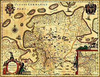
Friesland, historically known as Frisia, is a province of the Netherlands located in the northern part of the country. It is situated west of Groningen, northwest of Drenthe and Overijssel, north of Flevoland, northeast of North Holland, and south of the Wadden Sea. As of January 2020, the province had a population of 649,944 and a total area of 5,749 km2 (2,220 sq mi).
Rurik, according to the 12th-century Primary Chronicle, was a Varangian chieftain of the Rus' who in the year 862 gained control of Ladoga, and built the Novgorod in the same year. This legendary figure was considered by later rulers to be the founder of the Rurik dynasty, which ruled the Kievan Rus' and its successor states, including the Kingdom of Ruthenia, the Principality of Tver, Grand Duchy of Vladimir, the Grand Duchy of Moscow, the Novgorod Republic and the Tsardom of Russia, until the 17th century.

For codepage, see CP850. Year 850 (DCCCL) was a common year starting on Wednesday of the Julian calendar.

Pier Gerlofs Donia was a Frisian rebel leader and pirate. He is best known by his West Frisian nickname Grutte Pier, or by the Dutch translation Grote Pier which referred to his legendary size and strength.

The Battle of Heiligerlee was fought between Dutch rebels and the Spanish army of Friesland. This was the first Dutch victory during the Eighty Years' War.
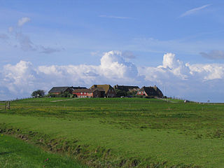
A terp, also known as a wierde, woerd, warf, warft, werf, werve, wurt or værft, is an artificial dwelling mound found on the North European Plain that has been created to provide safe ground during storm surges, high tides and sea or river flooding. The various terms used reflect the regional dialects of the North European region. In English sources, terp appears to be by far the most common term used.
John W. Bryant was the founder and first leader of a Mormon fundamentalist sect that is today known as the Church of the New Covenant in Christ and is headquartered near Salem, Oregon.
Ygo Gales Galama was a 15th-century Frisian warlord and Galama-patriarch.
Not to be confused with Jancko Douwema of Langweer/Langwar (1383–1476) from the Donia War (1458–1464).

Arum is a village in the Súdwest-Fryslân municipality in the Dutch province of Friesland. It is located about 5 km southeast of the city of Harlingen.
Sytse Dekama was the twelfth potestaat of Friesland, which was in the time of the religious disputes between Schieringers and Vetkopers. There is little known about Sytse Dekama only historian Occo Scarlensis mentions Dekama. He succeeded Juw Juwinga when he died in 1396.
Odo Botnia was the fourteenth potestaat of Friesland, now a province in the Netherlands.

Friese Freedom or Freedom of the Frisians was the absence of feudalism and serfdom in Frisia, the area that was originally inhabited by the Frisians. Historical Frisia included the modern provinces of Friesland and Groningen, and the area of West Friesland, in the Netherlands, and East Friesland in Germany. During the period of Frisian freedom the area did not have a sovereign lord who owned and administered the land. The freedom of the Frisians developed in the context of ongoing disputes over the rights of local nobility.
The County of East-Frisia was a county in the region of East Frisia in the northwest of the present-day German state of Lower Saxony.

Almenum is a historic locality in the northern Netherlands, near Midlum, Friesland the site of the first Christian church in Friesland. Saint Boniface set up a local church in the locality in 754. The location of the church is on the Terp of Almenum, a mound of earth about five meters high. Almenum is named after the place where someone called "Allaman" lived. The -um suffix is derived from the West Frisian word "hiem" meaning "home". An alternative explanation for the name of the locality is that it originally meant common lands for grazing cattle. In Icelandic this kind of land still uses the term "almenningurheim".
Ghiyath al-Din, also transcribed as Ghiyāthu'd-Dīn, Ghiyasuddin, etc. is the name of many persons in the Islamic world. It may refer to:

Bloemkamp Abbey is a former Cistercian abbey in the Netherlands, located in Hartwerd in the municipality of Wûnseradiel to the north-east of Bolsward, in the province of Friesland.
To Deng railway station is a railway station located in To Deng Subdistrict, Su-ngai Padi District, Narathiwat. It is a class 3 railway station located 1,125.658 km (699.5 mi) from Thon Buri railway station.