
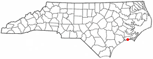
Carteret County is located in the U.S. state of North Carolina. As of the 2010 census, the population was 66,469. Its county seat is Beaufort. The county was created in 1722 as Carteret Precinct and gained county status in 1739. It was named for Sir George Carteret, one of the 17th century English Lords Proprietor, or for his descendant and heir John Carteret, 2nd Earl Granville.

Atlantic Beach is a town in Carteret County, North Carolina, United States. It is one of the five communities located on Bogue Banks. The population was 1,495 at the 2010 census.
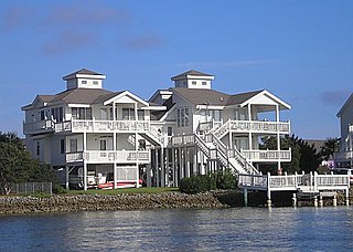
Emerald Isle is a town in Carteret County, North Carolina, United States. It is part of the Crystal Coast and is located entirely on Bogue Banks. The population was 3,655 at the 2010 census, but as many as 50,000 tourists each week inhabit the area during the summer season, filling up vacant rental properties that do not count toward official census results.
Indian Beach is a town in Carteret County, North Carolina, United States. The population was 112 as of the 2010 census.

Morehead City is a port town in Carteret County, North Carolina, United States. The population was 8,661 at the 2010 census. Morehead City celebrated the 150th anniversary of its founding on May 5, 2007. It forms part of the Crystal Coast.

Pine Knoll Shores is a town in Carteret County, North Carolina, United States. The population was 1,339 at the 2010 census. One of North Carolina's state aquariums is located here.

Arapahoe is a town in Pamlico County, North Carolina, United States. As of the 2010 census, the town population was 556. Arapahoe shares many of its roles and duties with Minnesott Beach, North Carolina. It is part of the New Bern, North Carolina Micropolitan Statistical Area.
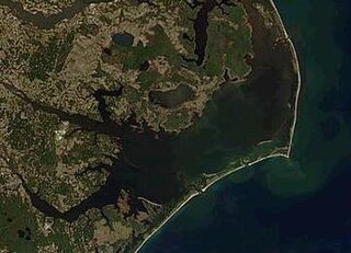
Pamlico Sound in North Carolina in the US is the largest lagoon along the North American East Coast, extending 80 mi (130 km) long and 15 to 20 miles wide. It is part of a large, interconnected network of lagoon estuaries that includes Albemarle Sound, Currituck Sound, Croatan Sound, Pamlico Sound, Bogue Sound, Core Sound, and Roanoke Sound. Together, these sounds, known as the Albemarle-Pamlico sound system, comprise the second largest estuary in the United States, covering over 3,000 sq. mi. of open water. The Pamlico Sound is separated from the Atlantic Ocean by the Outer Banks, a row of low, sandy barrier islands that include Cape Hatteras National Seashore, Cape Lookout National Seashore, and Pea Island National Wildlife Refuge. The Albemarle-Pamlico Sound is one of nineteen great waters recognized by the America's Great Waters Coalition.
Shackleford Banks is a barrier island system on the coast of Carteret County, North Carolina. It contains a herd of feral horses, scallop, crabs and various sea animals, including summer nesting by loggerhead turtles. It is a tourist and beach camping site.
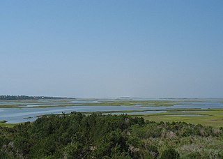
The Core Sound is a large and shallow body of water in eastern North Carolina located between the mainland of Carteret County and Core Banks, part of the Outer Banks of North Carolina, located west of the Atlantic Ocean and east of Bogue Sound. Pamlico Sound is located to the north and east.

The Lumber River is a 133-mile-long (214 km) river in south-central North Carolina in the flat Coastal Plain. European settlers first called the river Drowning Creek, which still is the name of its headwater. The waterway known as the Lumber River extends downstream from the Scotland County-Hoke County border to the North Carolina-South Carolina border. Soon after crossing into South Carolina, the Lumber River flows into the Little Pee Dee River, which flows into the Pee Dee River, or Great Pee Dee River. Finally, the combined waters flow into Winyah Bay and the Atlantic Ocean.

In North Carolina, the Crystal Coast is an 85-mile stretch of coastline that extends from the Cape Lookout National Seashore, which includes 56 miles of protected beaches, southwestward to the New River. The Crystal Coast is a popular area with tourists and second-home owners in the summer.
Bogue Banks form a 21-mile (34 km) barrier island off the mainland of North Carolina in Carteret County. The island, separated from the mainland by Bogue Sound, runs east to west, with the ocean beaches facing due south. Bogue Banks is the only island on the Carteret County shore that has been developed with housing: numerous communities are located on the island and can be accessed by one of two bridges across Bogue Sound, either from Morehead City to Atlantic Beach, which is the more heavily traveled bridge, or from Cape Carteret to Emerald Isle. The communities of Bogue Banks are the most prominent of the Crystal Coast. NC 58 traverses a majority of the island's length. There are several hotels that dot the island, but most of the land contains private houses, some of which are rented out during the summer, or maritime forest. Stores and other commercial properties are limited to the five main communities.
Bogue Sound is a medium-sized geographic sound in the state of North Carolina. The sound is part of North Carolina's "Crystal Coast", a tourism marketing term that is also used interchangeably with the term "Southern Outer Banks."
The Gales Creek area of Carteret County, North Carolina is part of the greater Newport, North Carolina area.

The Newport River is a small river in North Carolina that runs approximately twelve miles southeast through the town of Newport with its mouth opening into Bogue Sound, between Morehead City and Beaufort. It is popular for flatwater paddling and canoeing.

Broad Creek is an unincorporated area and census-designated place (CDP) in Carteret County, North Carolina, United States. As of the 2010 census it had a population of 2,334. It is part of the greater Newport area and currently shares the Newport zip code of 28570.

Broad Creek is a water body bordering the community of Broad Creek, North Carolina. The creek empties into Bogue Sound, which is separated from the Atlantic Ocean by Bogue Banks, part of North Carolina's barrier islands known as the Southern Outer Banks. The creek also runs through the Croatan National Forest.
Barden Inlet is the southernmost of the Outer Banks water inlets. Located just northwest of Cape Lookout in the U.S. state of North Carolina, the inlet connects Onslow Bay of the Atlantic Ocean with Core Sound. It separates the Shackleford Banks from the Core Banks.
Marine Corps Auxiliary Landing Field Bogue, also known as Bogue Field, is an 875-acre (3.54 km2) landing field located on Bogue Sound that serves as a Marine Corps’ East Coast site for Field Carrier Landing Practice (FCLP). It is a sub facility of MCAS Cherry Point in Havelock in Craven County and one of three USMC facilities in Carteret County. The others include Atlantic Airfield, a Cherry Point sub installation which is sparsely manned and Radio Island shipping terminal, between Morehead City and Beaufort, which falls under control of Camp Lejeune, though it is only manned during active military operations. Another USMC facility, Oak Grove Airfield, near Pollocksville in Jones County, in also controlled by Cherry Point and in rarely manned unless training is conducted there. By Bogue Field being available for performing many of these landings at night, pilots simulate landing on an aircraft carrier or an amphibious assault ship, which provides the force with the means to forward deploy its aviation assets in order to have a more readily accessible aviation punch for the Marine Air Ground Task Force (MAGTF) commander on the battlefield.