
Renfrewshire is one of the 32 council areas of Scotland.
The Gorbals is an area in the city of Glasgow, Scotland, and former burgh, on the south bank of the River Clyde. By the late 19th century, it had become densely populated; rural migrants and immigrants were attracted by the new industries and employment opportunities of Glasgow. At its peak, during the 1930s, the wider Gorbals district had swollen in population to an estimated 90,000 residents, giving the area a very high population density of around 100,000 per sq. mi. (40,000/km2). Redevelopment after WWII has taken many turns, and the area's population is substantially smaller today. The Gorbals was also home to 16 high rise flat blocks; only six are standing as of 2024, and two of them are set to come down some point this year.

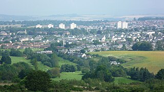
Paisley is a large town situated in the west central Lowlands of Scotland. Located north of the Gleniffer Braes, the town borders the city of Glasgow to the east, and straddles the banks of the White Cart Water, a tributary of the River Clyde.

Pollokshaws is an area on the South side of the city of Glasgow, Scotland. It is bordered by the residential neighbourhoods of Auldhouse to the east, Eastwood and Hillpark to the south and Shawlands to the north, with the Glasgow South Western Line railway and the open lands of Pollok Country Park to the west. The White Cart Water flows through the area.

Castlemilk is a district of Glasgow, Scotland. It lies to the far south of the city centre, adjacent to the Croftfoot and Simshill residential areas within the city to the north-west, the town of Rutherglen - neighbourhoods of Spittal to the north-east and Fernhill to the east, Linn Park and its golf course to the west, and the separate village of Carmunnock further south across countryside.

Pollokshields is an area in the Southside of Glasgow, Scotland. Its modern boundaries are largely man-made, being formed by the M77 motorway to the west and northwest with the open land of Pollok Country Park and the Dumbreck neighbourhood beyond, by the Inverclyde Line railway and other branches which separate its territory from the largely industrial areas of Kinning Park, Kingston and Port Eglinton, and by the Glasgow South Western Line running from the east to south, bordering Govanhill, Strathbungo, Crossmyloof and Shawlands residential areas. There is also a suburban railway running through the area.

Johnstone is a town in the administrative area of Renfrewshire and larger historic county of the same name, in the west central Lowlands of Scotland.
Cranhill is an inner city district and housing scheme in the north east of Glasgow, Scotland. Cranhill was developed from public funding in the early 1950s and was originally, chiefly composed of four-storey tenement blocks surrounding a patch of grassland, which became Cranhill Park. Later development saw the building of three tower blocks, surrounded by rows of terraced maisonettes. In more recent years, a number of semi-detached and detached homes have been built. The area also hosts some shops, two primary schools and nurseries, a community centre and the Cranhill water tower.
Sandyhills is an area of the Scottish city of Glasgow. It is situated north of the River Clyde and has fallen within the Shettleston ward of Glasgow City Council since 2007.
Sighthill is a neighbourhood in the Scottish city of Glasgow. It is situated north of the River Clyde and is part of the wider Springburn district in the north of the city. It is bordered to the north by Cowlairs, to the east by the Springburn Bypass road and the Royston neighbourhood, to the west by the Glasgow to Edinburgh via Falkirk Line and to the south by the Townhead interchange of the M8 Motorway.
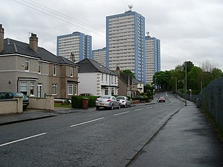
Hutchesontown is an inner-city area in Glasgow, Scotland. Mostly residential, it is situated directly south of the River Clyde and forms part of the wider historic Gorbals district, which is covered by the Southside Central ward under Glasgow City Council.
Beaumont Road is a housing estate located in Leyton in East London. It is the largest housing estate in the borough of Waltham Forest. It is situated just south of the Bakers Arms, on Leyton High Road.

The Calders is a residential neighbourhood in Edinburgh, Scotland – not to be confused with the Calders of West Lothian aka West Calder, Mid Calder and East Calder, three separate villages. It is sometimes considered to be part of Wester Hailes or Sighthill, larger developments to its south and east respectively. From 2007 to 2017, it fell within the Sighthill/Gorgie multi-member ward of the City of Edinburgh Council administration along with Sighthill, but following a boundary change has been in the Pentland Hills ward since then, along with Wester Hailes.
Moredun is a district in the south-east of Edinburgh, the capital of Scotland. It is east of Liberton, while Craigour is situated just to its north.
Muirhouse is a housing estate in the north of Edinburgh, the capital of Scotland.
Kilmaurs Place, The Place or Kilmaurs House, is an old mansion house and the ruins of Kilmaurs Tower grid reference NS41234112 are partly incorporated, Kilmaurs, East Ayrshire, Scotland. The house stands on a prominence above the Carmel Water and has a commanding view of the surrounding area. Once the seat of the Cunningham Earls of Glencairn it ceased to be the main residence after 1484 when Finlaystone became the family seat. Not to be confused with Kilmaurs Castle that stood on the lands of Jocksthorn Farm.

Foxbar is a district of Paisley, bordered by the Gleniffer Braes and Paisley town centre. Consisting mostly of residential areas, Foxbar has rapidly grown over the past century to be one of the largest housing areas in the town. An area of low socioeconomic levels and poor social mobility, the local authority has invested significantly in the area, which nowadays boasts multiple community centres, public parks and social areas.

Glasgow, the largest city in Scotland, has several distinct styles of residential buildings. Building styles reflect historical trends, such as rapid population growth in the 18th and 19th centuries, deindustrialisation and growing poverty in the late 20th century, and civic rebound in the 21st century.

Orchard Park Estate is an area or housing estate situated on the north-western side of Kingston upon Hull, England.
The following shows the public housing estates in Pok Fu Lam, Aberdeen, Wong Chuk Hang and Ap Lei Chau of Southern District, Hong Kong.