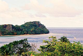
Galoa is a volcanic island of the Kadavu Group of Fiji. [1] It is located in the south of Kadavu and can be reached only by boat.
Galoa is a volcanic island of the Kadavu Group of Fiji. [1] It is located in the south of Kadavu and can be reached only by boat.

Fiji is a group of volcanic islands in the South Pacific, lying about 4,450 kilometres (2,765 mi) southwest of Honolulu and 1,770 km (1,100 mi) north of New Zealand. Of the 332 islands and 522 smaller islets making up the archipelago, about 106 are permanently inhabited. The total land size is 18,272 km2 (7,055 sq mi). It has the 26th largest Exclusive Economic Zone of 1,282,978 km2 (495,361 sq mi).

In Fijian mythology, Dakuwaqa (Dakuwanga) is a shark deity and often appears as a fierce sea monster, guarding the islands. He was greatly respected by fishermen because he protected them from any danger at sea and its denizens.
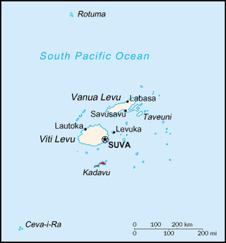
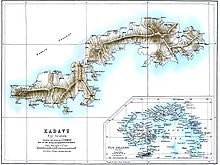
Kadavu, with an area of 411 square kilometres (159 sq mi), is the fourth largest island in Fiji, and the largest island in the Kadavu Group, a volcanic archipelago consisting of Kadavu, Ono, Galoa and a number of smaller islands in the Great Astrolabe Reef. Its main administrative centre is Vunisea, which has an airport, a high school, a hospital, and a government station, on the Namalata Isthmus where the island is almost cut in two. Suva, Fiji's capital, lies 88 kilometres to the north of Kadavu. The population of the island province was 10,167 at the most recent census in 2007.
Burebasaga is the largest of the three confederacies that make up Fiji's House of Chiefs, to which some of the Fijian chiefs belong.
Jesoni Vitusagavulu is a Fijian businessman and diplomat, who was appointed as Fiji's fifth Fijian Ambassador to the United States on 26 May 2005, succeeding Anare Jale. He is also accredited as Ambassador to Cuba and Mexico, and High Commissioner to Canada. He presented his credentials to President George W. Bush on 3 October 2005, and to Governor-General Michaëlle Jean of Canada on 13 June 2006.

The Eastern Division of Fiji is one of Fiji's four divisions. It consists of Kadavu Province, Lau Province, Lomaiviti Province and Rotuma.
The Kadavu Group is an archipelago south of Viti Levu, one of Fiji's two main islands. Dominated by Kadavu Island, the fourth largest island in Fiji, the group also includes Ono, Dravuni, Galoa and a number of islets in the Great Astrolabe Reef.
Ono Island is a member of the Kadavu Group, an outlier to Kadavu Island, to the south of Viti Levu, one of Fiji's two main islands. It is separated from Kadavu Island by the Ono Channel. Located at 18.88° South and 178.50° East, this volcanic island is enclosed by the Great Astrolabe Reef. It covers an area of 30 square kilometers. Its maximum altitude is 354 meters. There are seven villages: Vabea (south), Waisomo (south), Narikoso (southeast), Naqara (northeast), Nabouwalu (northwest), Buliya, Dravuni.

Dravuni is a volcanic island in the Kadavu Group of islands in Fiji. Covering an area of 0.8 km2 (0.3 sq mi), it is located at 18.78° South and 178.53° East, and reaches a maximum altitude of 40 metres (131 ft).

Ono-i-Lau is a group of islands within a barrier reef system in the Fijian archipelago of Lau Islands. There are four central volcanic islands: Onolevu, Doi Lovoni and Ndavura, the uppermost parts of the volcanic edifice rising from the Lau Ridge slightly more than 1,000 metres below sea level and on which the reef and other islands are built. There are also three clusters of coral limestone islets, Yanuya and Mana on the barrier reef and Niuta. A sand cay, Udui, is not counted as one of the six “islands”.
Emasi Qovu is a former Fijian school principal, civil servant, and politician. He was a member of the House of Representatives of Fiji from 2001 to 2006. Whilst in Parliament he was appointed Government Whip in 2005–2006.
Nagigia Island is an island located at the most south-western point of the Fiji Islands. It is also known on some charts and maps as Denham Island. The island has an area of 26 acres (11 ha), is privately owned and has a large sheltered lagoon suitable for snorkelling.
The Great Astrolabe Reef is in Fiji and surrounds the fourth largest island, Kadavu Island, which is approximately 65 km in length. Kadavu Island is approximately 100 km south of Viti Levu, the main island of Fiji.
Naiqoro Passage is located near Kadavu Island in Fiji and is one of the main inlets to the Great Astrolabe Reef. It was officially recognized as a marine reserve by the Ministry of Fisheries in 2018. The passage is a dive site. The Society for the Conservation of Reef Fish Aggregations surveyed the area in 2011.
Kadavu Province is one of fourteen provinces of Fiji, and forms part of the Eastern Division, which also includes the provinces of Lau, Lomaiviti and Rotuma. Kadavu also belongs to the Burebasaga Confederacy, a hierarchy of chiefs from southern and western Fiji with Roko Tui Dreketi of Rewa as the paramount chief.

Lau Province is one of fourteen provinces of Fiji. Its capital is at Tubou, at the southern end of the island of Lakeba. The province forms part of the country's Eastern Division, and of the Tovata Confederacy, a traditional hierarchy of chiefs from northern and eastern Fiji.

Severe Tropical Cyclone Joni was a damaging tropical cyclone that impacted the island nations of Tuvalu and Fiji. It was first noted within the South Pacific Convergence Zone at the start of December 1992, as a shallow tropical depression in the vicinity of the island nation Tuvalu. Over the next few days the system gradually developed further as it affected Tuvalu, before it was declared to be a tropical cyclone and named Joni by the Fiji Meteorological Service (FMS) during December 7. Over the next couple of days the system intensified further as it was steered south-westwards and posed a threat towards the Fijian dependency of Rotuma and the French territory of Wallis and Futuna. The system subsequently peaked as a Category 4 severe tropical cyclone on the Australian tropical cyclone intensity scale as it approached the Fijian Islands during December 10. Over the next couple of days the system moved through the Fijian Islands, before it became an extratropical cyclone during December 13. The system was last noted during the next day as it was absorbed by a mid-latitude trough of low pressure to the east of New Zealand.
Nabukelevu is a volcano located on the southwest portion of Kadavu Island in Fiji. It is 805 metres (2,641 ft) tall, and last erupted around 1660. It has formed lava domes
Apaitia Seru is a Fijian lawyer and former politician and judge, who served briefly as Attorney General of Fiji in 1992. He was also a member of the House of Representatives from 1992 to 1994. He held the Kadavu Fijian Communal Constituency for the Soqosoqo ni Vakavulewa ni Taukei
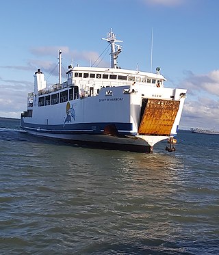
Patterson Brothers Shipping Company LTD is Fiji's longest running inter-island ferry operation bridging the gap between Viti Levu, Vanua Levu, and Ovalau daily, They also provide trips to Kadavu and Koro Island.
19°04′40″S178°11′00″E / 19.07778°S 178.18333°E
| | This article about a geographical location in Fiji is a stub. You can help Wikipedia by expanding it. |