Franklin County is a county along the Gulf of Mexico in the Florida panhandle of the U.S. state of Florida. As of the 2010 census, the population was 11,549, making it the third-least populous county in Florida. The county seat is Apalachicola.

Bokeelia is a census-designated place (CDP) located on Pine Island in Lee County, Florida, United States. As of the 2000 census, the CDP had a total population of 1,997. It is part of the Cape Coral-Fort Myers, Florida Metropolitan Statistical Area. Bokeelia is still home to one of Lee County's first pioneer families, the Padillas, who came by way of Cayo Costa.

Captiva is a census-designated place in Lee County, Florida, United States. It is located on Captiva Island. As of 2015 the CDP had a total year-round population of 379. It is part of the Cape Coral-Fort Myers, Florida Metropolitan Statistical Area.

Matlacha is a census-designated place (CDP) in Lee County, Florida, United States. As of the 2000 census, the CDP had a total population of 735. It is part of the Cape Coral-Fort Myers, Florida Metropolitan Statistical Area.

Pine Island Center is a census-designated place (CDP) located on Pine Island in Lee County, Florida, United States. The population was 1,721 at the 2000 census. It is part of the Cape Coral-Fort Myers, Florida Metropolitan Statistical Area.
Pine Island Sound is located in Lee County, Florida, lying between Pine Island and the barrier islands of Sanibel Island, Captiva Island, North Captiva Island and Cayo Costa, which separate the Sound from the Gulf of Mexico. The Sound connects to Gasparilla Sound and Charlotte Harbor to the north, and to San Carlos Bay and the Caloosahatchee River to the south. The Sound is conterminous with the Pine Island Sound Aquatic Preserve, which was established in 1970 and consists of 54,000 acres (220 km2) of submerged land. Important habitats in the Sound include mangroves, seagrasses, salt marshes, oyster communities and tidal flats.

The Butt of Lewis is the most northerly point of Lewis in the Outer Hebrides. The headland, which lies in the North Atlantic, is frequently battered by heavy swells and storms and is marked by the Butt of Lewis Lighthouse. The nearest populated area is the village of Eoropie, about 1 mile (1.6 km) to the south.
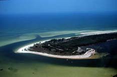
Anclote Key is an island off the Gulf Coast of the U.S. state of Florida, the largest island in the Anclote Keys, located at 28°11′16″N82°50′44″W near Tarpon Springs. Its name originates from the Spanish term for "anchor." The island is accessible only by boat and is split between Anclote Key Preserve State Park and Anclote National Wildlife Reserve. The island contains mangrove wetlands, coastal pine flatwoods, and beaches. A large number of shorebirds nest and breed on Anclote Key and the surrounding islands. Sand Key is located nearby. Most of the island is located within Pasco County, while its southernmost section is in Pinellas County. The island is home to the Anclote Keys Light.
Blind Pass is the strait that separates Captiva Island from Sanibel Island in Lee County, Florida.
Placida is an unincorporated community in Charlotte County, Florida, United States. It is located near where County Road 771 becomes County Road 775, and the Coral Creek meets Gasparilla Sound.

Martin is an unincorporated community in Marion County, Florida, United States, located on County Road 25A. The community is part of the Ocala Metropolitan Statistical Area.

Canarreos Archipelago is an archipelago of Cuba.
Redfish Pass is a strait in Florida that connects Pine Island Sound with the Gulf of Mexico. It also separates Captiva Island on the south from North Captiva Island on the north. The pass was created by the hurricane of 1921 which divided the once larger Captiva Island. It is named after the many redfish caught in its channel soon after formation, and remains a popular sports fishing destination in Southwest Florida.
Captiva Pass is the strait that separates North Captiva Island from La Costa Island in Lee County, Florida.
Gasparilla Pass is an inlet southwest of the town of Placida, Florida, United States. It connects Placida Harbor with the Gulf of Mexico separating Gasparilla Island on the south from Little Gasparilla Island on the north.

The BT Centre is the global headquarters and registered office of BT Group, located in a 10-storey office building on Newgate Street in the City of London, London, England. It is opposite St. Paul's tube station. It was completed in 1985.
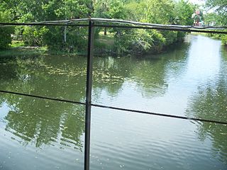
Homosassa River is a 7.7-mile-long (12.4 km) river in Citrus County, Florida, in the western part of the state. Its headwaters are the Homosassa Springs, and from there it flows west into the Gulf of Mexico. The river is home to common bottlenose dolphins, West Indian manatees, alligator snapping turtles, nine-banded armadillos, snakes, birds, eastern box turtles, oysters, raccoons, American alligators, Virginia opossums, North American river otters and many species of both freshwater and saltwater fish. The Homosassa River is an estuary, which means that as it moves inland, it changes from salt water to fresh very gradually, and the river is brackish. The river is good for canoeing and kayaking.
Boca Grande Key is an island in the Florida Keys in Monroe County, Florida, United States. It is within the boundaries of the Key West National Wildlife Refuge. It is 183 acres (74 ha) in size.
Punta Gorda Fish Co. was a fishing company established in the late 19th century in Punta Gorda, Florida. At least ten of the fish shacks and icehouses built by the company have been listed on the National Register of Historic Places.

The Boca Grande Causeway is a causeway located in Charlotte County, Florida connecting the community of Boca Grande on Gasparilla Island with the mainland near Placida. The 2.5 mile causeway crosses Gasparilla Sound and consists of three bridges, and is the only vehicular access to the island.