
Senegal, officially the Republic of Senegal, is the westernmost country in West Africa, situated on the Atlantic Ocean coastline. It borders Mauritania to the north, Mali to the east, Guinea to the southeast and Guinea-Bissau to the southwest. Senegal nearly surrounds The Gambia, a country occupying a narrow sliver of land along the banks of the Gambia River, which separates Senegal's southern region of Casamance from the rest of the country. It also shares a maritime border with Cape Verde. Senegal's economic and political capital is Dakar.

The Gambia, officially the Republic of The Gambia, is a country in West Africa. Geographically, The Gambia is the smallest country in continental Africa; it is surrounded by Senegal on all sides except for the western part, which is bordered by the Atlantic Ocean.
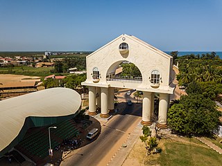
Banjul, officially the City of Banjul, is the capital of The Gambia. It is the centre of the eponymous administrative division which is home to an estimated 400,000 residents, making it The Gambia's largest and most densely populated metropolitan area. The city Banjul is located on St Mary's Island, where the Gambia River enters the Atlantic Ocean.

The first written records of the region come from Arab traders in the 9th and 10th centuries. In medieval times, the region was dominated by the Trans-Saharan trade and was ruled by the Mali Empire. In the 16th century, the region came to be ruled by the Songhai Empire. The first Europeans to visit the Gambia River were the Portuguese in the 15th century, in 1447, who attempted to settle on the river banks, but no settlement of significant size was established. Descendants of the Portuguese settlers remained until the 18th century. In the late 16th century, English merchants attempted to begin a trade with the Gambia, reporting that it was "a river of secret trade and riches concealed by the Portuguese."

The Gambia is a very small and narrow African country with the border based on the Gambia River. The country is less than 48 kilometres (30 mi) wide at its greatest width. The country's present boundaries were defined in 1889 after an agreement between the United Kingdom and France. It is often claimed by Gambians that the distance of the borders from the Gambia River corresponds to the area that British naval cannon of the time could reach from the river's channel. However, there is no historical evidence to support the story, and the border was actually delineated using careful surveying methods by the Franco-British boundary commission. The Gambia is almost an enclave of Senegal and is the smallest country on mainland Africa.

The Gambia River is a major river in West Africa, running 1,120 kilometres (700 mi) from the Fouta Djallon plateau in north Guinea westward through Senegal and The Gambia to the Atlantic Ocean at the city of Banjul. It is navigable for about half that length.
Senegambia, officially the Senegambia Confederation or Confederation of Senegambia, was a loose confederation in the late 20th century between the West African countries of Senegal and its neighbour The Gambia, which is almost completely surrounded by Senegal. The confederation was founded on 1 February 1982 following an agreement between the two countries signed on 12 December 1981. It was intended to promote cooperation between the two countries, but was dissolved by Senegal on 30 September 1989 after The Gambia refused to move closer toward union. The Senegambia Confederation should not be confused with the historic Senegambia region, generally shortened to the Senegambia.

Janjanbureh or Jangjangbureh is a town, founded in 1823, on Janjanbureh Island, also known as MacCarthy Island, in the Gambia River in eastern Gambia. Until 1995, it was known as Georgetown and was the second largest town in the country. It is the capital of Janjanbureh Local Government Area, and the Janjanbureh district. The population of the Janjanbureh LGA was 127,333 at the 2013 population census.

Bakau is a town on the Atlantic coast of Gambia, west of Gambia's capital city of Banjul. It is known for its botanical gardens, its crocodile pool Bakau Kachikally and for the beaches at Cape Point. Bakau is the first major suburb outside Banjul and the most developed town in the Gambia. Close to Bakau and Banjul is Gambia's largest city, Serekunda.

Buxar district is one of the 38 districts of Bihar, India. Located in the southwestern part of the state, it is a primarily agricultural district. The district headquarters is at the town of Buxar. Buxar district was carved out from Bhojpur district on 17 March 1991.

Central River is the largest of the five administrative divisions of the Gambia. Its capital is Janjanbureh, on MacCarthy Island. The largest settlement is Bansang, with an estimated population in 2008 of 8,381.

Nioro du Rip is a town and urban commune in the south-west of Sénégal, situated about 60 km (37 mi) to the south-west of Kaolack and 27 km (17 mi) from the border with The Gambia.

Avaux is a commune in the Ardennes department and Grand Est region of north-eastern France.
The tourism industry today in the Gambia started when a party of 300 Swedish tourists arrived in 1965. That pioneering trip was organised by a Swede named Bertil Harding together with the tour operators Vingresor. It was seen as an ideal place to escape the harsh winter months of Scandinavia where Europeans would enjoy not only sun, sand and beaches but also experience the excitement of a real African holiday. It also offered a new opening for an affordable holiday to increasing numbers of traveling Europeans.

Bao BolongWetland Reserve is a protected area in The Gambia. Established in 1996, it covers 296.5 square kilometres.
Gambissara Forest Park is a forest park in the Gambia. Established on January 1, 1954, it covers 308 hectares.
Demba Kunda is a small town in south-eastern Gambia. It is located in Fulladu East District in the Upper River Division. As of 2009, it has an estimated population of 5283.
Garowol or Garawoll is a small town in eastern Gambia near the border with Senegal. It is located in Kantora District in the Upper River Division. As of 2012, it has an estimated population of 8,124.
Kartung or Kartong is a coastal village in south-western Gambia on the border with Senegal. It is located approximately 60 kilometres from Banjul and 9.5 kilometres from Gunjur. It is located in Kombo South District in the Western Division. As of 2009, it has an estimated population of 5213.

The Gambia–Senegal border is 749 km in length and runs on either side of the Gambia river.
