
El Jobean is an unincorporated community in Charlotte County, Florida, United States. It is located off County Road 776, on the northern banks of the Myakka River. The community is part of the Punta Gorda Metropolitan Statistical Area.
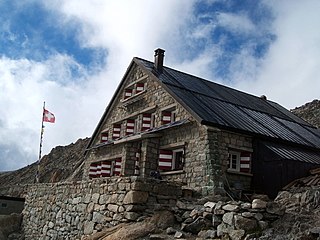
The Trient hut is a mountain hut in the Swiss alps, near the Swiss town of Martigny and the French town of Chamonix. The hut sits at an altitude of 3,170 m (10,400 ft), on a rock perched above the Trient Glacier. It can be reached on foot by mountaineers and strong hikers with experience of glacier travel. From the hut you can walk to the Albert Premier and Argentière huts in France, as well as the Cabane de Saleina (Switzerland) at the foot of the Aiguille d'Argentière. The hut is run by the SAC, the Swiss Alpine Club, and has 130 beds. It is a popular base for mountaineers exploring the area, e.g. Aiguille du Tour etc.

The Albert Premier Hut, sometimes known as Albert 1er is located on the Haute Route between Chamonix, France and Zermatt, Switzerland. It is at 2,702 metres (8,865 ft) above sea level. It is a popular hut with day hikers because of the short hike and beautiful views, like those into Chamonix Valley. The hut is usually used less by hikers attempting the entire Haute Route, but is popular as a base for climbers attempting the Aiguille du Chardonnet and the Aiguille du Tour.

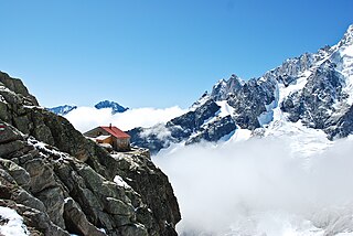
The Saleina Hut is a mountain hut in the Swiss Alps at 2,691 meters above sea level. It can be reached from the Val Ferret. The hut lies above the Saleina Glacier near the Aiguille d'Argentière in the Mont Blanc Massif, and has places for 48 people and is wardened between mid-June to mid-September.
The Cabane de l'A Neuve is a mountain hut in the Swiss Alps at 2,735 metres above sea level open for visitors. It can be reached from the Val Ferret. The hut lies below the Grand Darray on the south side in the Mont Blanc Massif. Other summits close to the hut are the Tour Noir, the Grande Lui and the Mont Dolent. Inauguration was 4 September 1927.
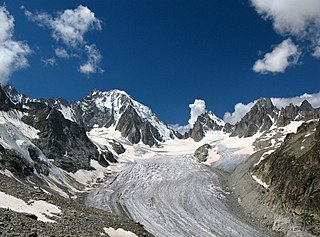
The Saleina Glacier is a 6 km (3.7 mi) long glacier (2002) situated on the north-eastern edge of the Mont Blanc Massif in the canton of Valais in Switzerland. It flows in a roughly north-easterly direction from the Aiguille d'Argentière, down towards the Val Ferret. The Saleina Hut sits above its right bank at an altitude of 2,691 meters above sea level.

The Monte Rosa Hut is a mountain hut located near Zermatt on the Monte Rosa massif and above the Grenzgletscher sitting on a glacier-free rocky part called Untere Plattje at an altitude of 2,883 metres (9,459 ft). It is owned by the Swiss Alpine Club. The hut is the start of the normal route to the summit and other mountains in the area. The first hut was built in 1894–1895 just next to the then still much higher Border Glacier at an altitude of 2,795 metres (9,170 ft). A completely new building was inaugurated in 2009, a hi-tech, energy-wise almost self-sufficient, environmentally friendly mountain hut based on wood with an aluminum shell.

The Hörnli Hut is a mountain hut located at the foot of the north-eastern ridge of the Matterhorn. It is situated at 3,260 metres (10,700 ft) above sea level, a few kilometres south-west of the town of Zermatt in the canton of Valais in Switzerland. It is also known as Berghaus Matterhorn.
The Solvay Hut or Solvay Bivouac is a mountain hut located on the north-eastern ridge of the Matterhorn, near Zermatt in the canton of Valais. At 4,003 metres (13,133 ft) it is the highest mountain hut owned by the Swiss Alpine Club, but can be used only in case of emergency. The Hörnli Hut lying on the same ridge is the starting point of the normal route to the summit.

The Valsorey Hut is a mountain hut of the Swiss Alpine Club, located south of Bourg-Saint-Pierre in the canton of Valais. The hut lies at a height of 3,030 metres above sea level, on the southwestern slopes of the Grand Combin in the Pennine Alps, facing Mont Vélan.

The Vignettes Hut is an alpine hut, located south of Arolla in the Swiss canton of Valais. It lies at a height of 3,160 metres above sea level, at the foot of the Pigne d'Arolla and near the Col de Chermotane in the Pennine Alps. All accesses to the hut involve glacier crossing.
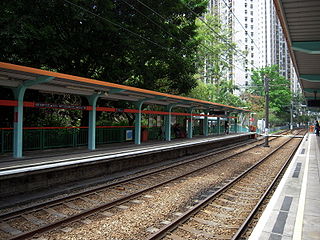
San Wai is an at-grade MTR Light Rail stop located at Tin King Road in Tuen Mun District, near San Wai Court. It began service on 24 September 1988 and belongs to Zone 3. It serves San Wai Court.

Psienie-Ostrów is a village in the administrative district of Gmina Czermin, within Pleszew County, Greater Poland Voivodeship, in west-central Poland. It lies approximately 10 kilometres (6 mi) north of Pleszew and 76 km (47 mi) south-east of the regional capital Poznań.
Nooksack Valley High School is a four-year public secondary school located in rural Whatcom County, just north of Nooksack. It is located just north of Nooksack, Washington, on E. Badger Road at the junction of State Route 9 and State Route 546. The school mascot is a Pioneer and the school colors are purple and white.

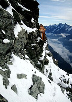
The Argentière Hut is a refuge in the Mont Blanc massif in the Alps. Built in 1974 by the Club Alpin Français, it is located above the north bank of the Argentière Glacier in France at an altitude of 2,691 meters above sea level.
Refuge de La Valette is a refuge in the French Alps, located in the town of Pralognan-la-Vanoise and a stop on the Tour des Glaciers de la Vanoise.

The Tête Rousse Hut is a mountain hut in the Mont Blanc massif in the French Alps. It is located beside the Tête Rousse Glacier at an altitude of 3,167 m. Owned by the Club Alpin Francais (CAF), it is normally reached after a multi-hour climb from Nid d'Aigle, the highest stop on the Mont Blanc Tramway. It is commonly used by mountaineers attempting to climb the modern normal route on the French side or Goûter route to the summit of Mont Blanc. Staying here, rather than continuing to the higher Goûter Hut adds an extra 2–3 hours to the ascent of Mont Blanc, but is less cramped than the latter and also avoids having to climb the dangerous 'Grand Couloir' later in the day when the risk of injury from stonefall is at its greatest.

Andělská Hora, originally called Engelsburg, is a castle above the village of Andělská Hora, about 7 kilometres (4 mi) southeast of Karlovy Vary, in the Karlovy Vary Region of the Czech Republic.

Pomeroy is a census-designated place (CDP) in Sadsbury Township, Chester County, Pennsylvania, United States. The population was 401 at the 2010 census.

Westwood is a census-designated place (CDP) in Valley Township, Chester County, Pennsylvania, United States. The population was 950 at the 2010 census.


