
Gandhinagar is the capital of the state of Gujarat in India. Gandhinagar is located approximately 23 km north of Ahmedabad, on the west central point of the Industrial corridor between Delhi, the political capital of India, and Mumbai, the financial capital of India.
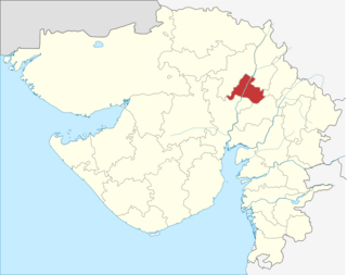
Gandhinagar district is an administrative division of Gujarat, India, whose headquarters are at Gandhinagar, the state capital. It was organized in 1964.
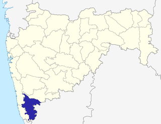
Kolhapur district is in Maharashtra state. The city of Kolhapur is the district headquarters. As of 2011, the district had population of 3,876,001, of which 33% were urban.

Gandhinagar is locality in Vellore, located on the northern bank of the Palar River.It is divided into Gandhi Nagar East and Gandhi Nagar West, it is the one of the posh residential and commercial locality in Vellore city.
Pan Bazaar is a locality in Guwahati, India surrounded by localities of Paltan Bazaar, Ambari and Fancy Bazaar. It is important part of the city centre on the southern bank of the river Brahmaputra.

Saptagram was a major port, the chief city and sometimes capital of southern Bengal, in ancient and medieval times, the location presently being in the Hooghly district in the Indian state of West Bengal. It is about 4 km from Bandel, a major rail junction. By the early twentieth century, the place had dwindled to a group of insignificant huts. The port had to be abandoned because of the silting up and consequent drying of the Saraswati River. It influenced the subsequent development and growth of Kolkata. H. E. A. Cotton writes, "Here then may be traced nucleus of the future city of Calcutta, and as time went on the silting up of the river opposite Satgaon still further favoured her fortunes."
Garchuk Lachit Garh or Fort, now popularly known as Lachit Garh, is located in the South Western part of the Guwahati city to the west of Ahomgaon. The fort was constructed during the times of Lachit Borphukan around the year 1670, and stretches from the northern Fatasil hills at Garchuk locality cutting across the National Highway (N.H.)-37 at Garchuk Charali to the southern hills via Pamahi and Moinakhurung. The length of the fortification is about 3 km.
Jhigli is a village located in Bhatgaon Union of Chhatak Upazila in Sunamganj District of the division of Sylhet, Bangladesh.

Pliskowola is a village in the administrative district of Gmina Osiek, within Staszów County, Świętokrzyskie Voivodeship, in south-central Poland. It lies approximately 4 kilometres (2 mi) west of Osiek, 17 km (11 mi) east of Staszów, and 69 km (43 mi) south-east of the regional capital Kielce.

Bhurshut / Bhurisrestha was a medieval Hindu kingdom spread across what is now Howrah and Hooghly districts in the Indian state of West Bengal.
Chandmari is one of the oldest locality of Guwahati, Assam, India. Situated towards the eastern side of the city. It is home to All India Radio, Guwahati centre and a couple of academic institutions such as Holy Childs Convent, Bhaskar Bidyapith Higher Secondary School, Gauhati Commerce College, Assam Engineering Institute to name a few. Many high schools and degree colleges are set up in this area adding to its educational atmosphere. This part of city is also known for its recreational facilities. Bohag Bihu is regularly organized since 1961 at the A.E.I. playground which is also known as Chandmari Bihutoli by Pub Guwahati Bihu Sanmilan. Durga Puja is also regularly celebrated at Chandmari by the Chandmari Sarbajanin Durga Puja Committee. The neighboring residential areas around Chandmari are Milonpur, Nizarapar, Bamunimaidam, Kannachal, Pub-Sarania, Bhaskar Nagar etc. This area has one of the oldest movie theatres 'Anuradha' showing national and international movies.
Ulubari is a locality in center of Guwahati, surrounded by localities of Bhangagarh and Paltan Bazaar. This area is known for sports facilities and markets dealings with all type of sports goods.
Lokhra, also known as Lakhra, is a locality in southern part of Guwahati in Assam. It is surrounded by Jalukbari, Lalmati and Basistha localities. It is near National Highway 37 and is 9 km and 18 km from Guwahati Railway Station and Airport, respectively.
Hatigaon is a locality in the southern part of Guwahati, Assam, India. It is surrounded by the localities of Ganeshguri, Bhetapara, Sijubari and Survey. It is near National Highway 37 and is 8 kilometres (5.0 mi) and 23 kilometres (14 mi) from Guwahati Railway Station and Airport, respectively. It is one of the Muslim dominated area of Guwahati. The only place in Guwahati where beef meat is sold and available.
Bonda is a locality of Guwahati surrounded by the locality of Narengi, India.
Udayan Vihar is a locality in Guwahati, surrounded by localities of Satgaon, Narengi and Noonmati.
Narangi Tinali is a locality of Guwahati, near the locality of Narengi.
Gandhi Nagar Jaipur railway station is a railway station in Jaipur. It is located in Bajaj nagar area of the city. It is close to Tonk Road and Jawahar Lal Nehru Marg (Jaipur) and mainly caters to the southern areas of the city. Many trains to and from Delhi have a stoppage at this station.

The West Karbi Anglong district is a new district formed out of the existing Karbi Anglong District of Assam in 2016. Hamren is the headquarter of the newly formed district. The district is a part of Karbi Anglong Autonomous Council, Diphu and it is administered according to the Sixth Scheduled of the Indian Constitution.


