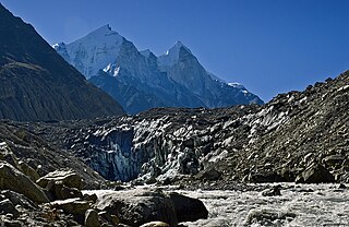
Gangotri is located in Uttarkashi District, Uttarakhand, India in a region bordering Tibet. This glacier, one of the primary sources of the Ganges, has a volume of over 27 cubic kilometers. The glacier is about 30 kilometres long and 2 to 4 km wide. Around the glacier are the peaks of the Gangotri Group, including several peaks notable for extremely challenging climbing routes, such as Shivling, Thalay Sagar, Meru, and Bhagirathi III. It flows roughly northwest, originating in a cirque below Chaukhamba, the highest peak of the group.

Dakshin Gangotri was the first scientific base station of India situated in Antarctica, part of the Indian Antarctic Programme. It is located at a distance of 2,500 kilometres (1,600 mi) from the South Pole. It is currently being used as a supply base and transit camp. The base is named after Dakshin Gangotri Glacier.
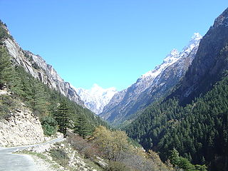
Gangotri is a town and a Nagar Panchayat (municipality) in Uttarkashi district in the state of Uttarakhand, India. It is 99 km from Uttarkashi, the main district headquarter. It is a Hindu pilgrim town on the banks of the river Bhagirathi – the origin of the river Ganges. The town is located on the Greater Himalayan Range, at a height of 3,100 metres (10,200 ft). According to popular Hindu legend, Goddess Ganga descended here when Lord Shiva released the mighty river from the locks of his hair.
The Chota Char Dham is an important Hindu pilgrimage circuit in Uttarakhand, in the Indian Himalayas. Located in the Garhwal region of the state of Uttarakhand, the circuit consists of four sites—Gangotri, Yamunotri, Kedarnath, and Badrinath. Badrinath is also one of the four destinations of the longer Char Dham from which the Chota Char Dham likely draws its name.

Gangotri National Park is a national park in Uttarkashi District of Uttarakhand in India, covering about 2,390 km2 (920 sq mi). Its habitat consists of coniferous forests, alpine meadows and glaciers. Gaumukh at Gangotri glacier, the origin of river Ganga, is located inside the park. Gangotri National Park was established in 1989.

Swami Sundaranand was an Indian Yogi, photographer, author and mountaineer who lectured widely in India on threats to the Ganges River and the loss of Himalayan glaciers due to global warming.

The Satopanth glacier is situated in the Indian state of Uttarakhand. The river Alaknanda, one of the primary headstreams of the Ganges, has its origin in the Satopanth glacier. The glacier is one of the most popular glaciers in Uttarakhand among tourists. Mountaineers consider it somewhat challenging to scale.

Uttarakhand has a total geographic area of 53,483 km2, of which 86% is mountainous and 65% is covered by forest. Most of the northern parts of the state are part of Greater Himalaya ranges, covered by the high Himalayan peaks and glaciers, while the lower foothills were densely forested till denuded by the British log merchants and later, after independence, by forest contractors. Recent efforts in reforestation, however, have been successful in restoring the situation to some extent. The unique Himalayan ecosystem plays host to many animals, plants and rare herbs. Two of India's great rivers, the Ganges and the Yamuna take birth in the glaciers of Uttarakhand, and are fed by myriad lakes, glacial melts and streams.
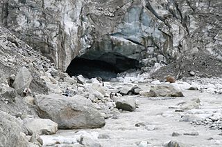
Gomukh, also known as "Gaumukh" or "Gomukhi", is the terminus or pout of the Gangotri Glacier and the source of the Bhagirathi River, one of the primary headstreams of the Ganga River. The word Gomukh/Gaumukh literally means "Mouth of a Cow."
Uttarakhand is a state in the northern part of India. It is often referred to as the "Devbhumi" due to its religious significance and numerous Hindu temples and pilgrimage sites found throughout the state. As a result, religious tourism forms a major portion of the tourism in the state. Uttarakhand is known for the natural environment of the Himalayas. 2019 Tourist Arrivals Domestic – 40,000,000 per/year and Foreigner – 150,000 per year. Tourism business in Uttarakhand generated ₹ 23,000 crores during 2013–14.

The Dakshin Gangotri Glacier is a small tongue of the polar continental ice sheet impinging on the Schirmacher Oasis of central Queen Maud Land, Antarctica. It was discovered by the Second Indian Expedition to Antarctica in 1983, and is named after the Gangotri Glacier in the Himalayas. The first Antarctic research base of India, Dakshin Gangotri is located near to the glacier. Since then its snout, and the area around it, has been regularly monitored and it has become a valuable site for tracking the impact of global warming through changes in the movement of the Antarctic ice sheet. The site is protected under the Antarctic Treaty System as Antarctic Specially Protected Area (ASPA) No.163.

Char Dham National Highway, is an under construction two-lane express National Highway with a minimum width of 10 metres in the Indian state of Uttarakhand under Char Dham Pariyojana. The under construction highway will complement the under-construction Char Dham Railway by connecting the four holy places in Uttarakhand states namely Badrinath, Kedarnath, Gangotri and Yamunotri. The project includes 900 km national highways which will connect whole of Uttarakhand state.

Bhagirathi Parbat III is a mountain in Uttarakhand, India. It is the 95th highest peak located entirely within Uttarakhand, India. The summit is 6,454 metres (21,175 ft). It is the third highest peak of the Bhagirathi Massif. It was first climbed by Britishers Kolin Kirkus and Charles Warren in 1933, by way of the southeast ridge.

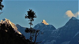
Bhagirathi Massif or Bhagirathi Group is a mountain range of Garhwal Himalaya in Gangotri Glacier Uttarakhand India, It has four peaks between 6856 meter and 6193 meter. The Bhagirathi I summits is 6856 meter or 22493 feet. It was first climbed by A Japanese team in 1980. It is surrounded by Glaciers on four side on the eastern side of the Massif is Vasuki Glacier, on the western side its Gangotri Glacier the main glacier in this area, northern side is surrounded by Chaturangi Glacier and southern side guarded by Swachhhand Glacier.

Vasuki Parbat or Vasuki Parvat is a mountain range of Garhwal Himalaya in Vasuki Glacier Uttarakhand, India. It has a subsidiary peak, Vasuki south. Vasuki Parbat stands majestically at 6792 meter and the south peak 6702 at meter. Its the 35th highest located entirely within the uttrakhand India. Nanda Devi, is the highest mountain in this category.
Janhukut is a mountain of Garhwal Himalaya in Uttarakhand India. Janhukut standing majestically at 6805 meter. It's the 31st highest located entirely within the uttrakhand India. Nanda Devi, is the highest mountain in this category. Janhukut is the 473rd highest peak in the world.
Satopanth South West also called P. 6770 is a mountain of the Garhwal Himalaya in Uttarakhand, India. The elevation of Satopanth south west is 6,770 metres (22,211 ft) and its prominence is 195 metres (640 ft). It is 40th highest located entirely within the Uttrakhand. Nanda Devi, is the highest mountain in this category. It lies in the same connecting ridge that joins Satopanth and Bhagirathi Parbat I. It lies 1.8 km SW of Satopanth. Its nearest higher neighbor Satopanth 7,075 metres (23,212 ft). It is located 3.4 km SE of Vasuki South 6,702 metres (21,988 ft) and 5.2 km NNW lies Bhagirathi I 6,856 metres (22,493 ft).
Jogin I is a mountain of the Garhwal Himalaya in Uttarakhand India.The elevation of Jogin I is 6,465 metres (21,211 ft) and its prominence is 843 metres (2,766 ft). It is 94th highest located entirely within the Uttrakhand. Nanda Devi, is the highest mountain in this category. It lies 5.4 km east of Gangotri III and 7.4 km west of Bhrigupanth 6,772 metres (22,218 ft). It lies 2.2 km South of Jogin II. Its nearest higher neighbor is Gangotri III 6,577 metres (21,578 ft). It is located 6.9 km NW of Thalaysagar 6,904 metres (22,651 ft) and 8.8 km NW lies Gangotri I 6,682 metres (21,923 ft).
Jogin III is a mountain of the Garhwal Himalaya in Uttarakhand, India. The elevation of Jogin III is 6,116 metres (20,066 ft). It is 155th highest located entirely within the Uttrakhand. Nanda Devi, is the highest mountain in this category.
Chandra Parbat South is a mountain of the Garhwal Himalaya in Uttarakhand India. It's the lowest among three peak's in the Chandra Massif. It is situated in the Gangotri National Park. The elevation of Chandra Parbat (South) is 6,557 metres (21,512 ft) and its prominence is 115 metres (377 ft). It is joint 74th highest located entirely within the Uttrakhand. Nanda Devi, is the highest mountain in this category. It lies 1.3 km SSW of Chandra Parbat I 6,739 metres (22,110 ft) its nearest higher neighbor. Satopanth 7,075 metres (23,212 ft) lies 4.1 km WSW and it is 6.2 km NNE of Swachhand 6,721 metres (22,051 ft). It lies 7.7 km east of Vasuki Parbat South 6,702 metres (21,988 ft).