
Sierra Vista is a city in Cochise County, Arizona, United States. According to the 2020 Census, the population of the city is 45,308, and is the 27th most populous city in Arizona. The city is part of the Sierra Vista-Douglas Metropolitan Area, with a 2010 population of 131,346. Fort Huachuca, a U.S. Army post, has been incorporated and is located in the northwest part of the city. Sierra Vista is bordered by the cities of Huachuca City and Whetstone to the north and Sierra Vista Southeast to the South.

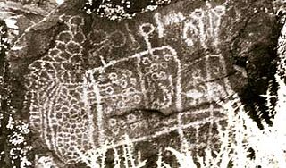
A petroglyph is an image created by removing part of a rock surface by incising, picking, carving, or abrading, as a form of rock art. Outside North America, scholars often use terms such as "carving", "engraving", or other descriptions of the technique to refer to such images. Petroglyphs, estimated to be 20,000 years old are classified as protected monuments and have been added to the tentative list of UNESCO's World Heritage Sites. Petroglyphs are found worldwide, and are often associated with prehistoric peoples. The word comes from the Greek prefix petro-, from πέτρα petra meaning "stone", and γλύφω glýphō meaning "carve", and was originally coined in French as pétroglyphe.
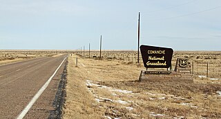
Comanche National Grassland is a National Grassland located in southeastern Colorado, United States. It is the sister grassland of Cimarron National Grassland and contains both prairie grasslands and canyons. It is separated into two sections, each operated by a local ranger district, one of which is in Springfield and the other of which is in La Junta. The grassland is administered by the Forest Service together with the Pike and San Isabel National Forests, and the Cimarron National Grassland, from common headquarters located in Pueblo, Colorado.

Desert View Watchtower, also known as the Indian Watchtower at Desert View, is a 70-foot (21 m)-high stone building located on the South Rim of the Grand Canyon within Grand Canyon National Park in Arizona, United States. The tower is located at Desert View, more than 20 miles (32 km) to the east of the main developed area at Grand Canyon Village, toward the east entrance to the park. The four-story structure, completed in 1932, was designed by American architect Mary Colter, an employee of the Fred Harvey Company who also created and designed many other buildings in the Grand Canyon vicinity including Hermit's Rest and the Lookout Studio. The interior contains murals by Fred Kabotie.

Coso Rock Art District is a rock art site containing over 100,000 Petroglyphs by Paleo-Indians and/or Native Americans. The district is located near the towns of China Lake and Ridgecrest, California. Big and Little Petroglyph Canyons were declared a National Historic Landmark in 1964. In 2001, they were incorporated into this larger National Historic Landmark District. There are several other distinct canyons in the Coso Rock Art District besides the Big and Little Petroglyph Canyons. Also known as Little Petroglyph Canyon and Sand Tanks, Renegade Canyon is but one of several major canyons in the Coso Range, each hosting thousands of petroglyphs. The majority of the Coso Range images fall into one of six categories: bighorn sheep, entopic images, anthropomorphic or human-like figures, other animals, weapons & tools, and "medicine bag" images. Scholars have proposed a few potential interpretations of this rock art. The most prevalent of these interpretations is that they could have been used for rituals associated with hunting.
Big and Little Petroglyph Canyons are two principal landforms within which are found major accumulations of Paleo-Indian and/or Native American Petroglyphs, or rock art, by the Coso People located in the Coso Range Mountains of the northern Mojave Desert, and now within the Naval Air Weapons Station China Lake, near the towns of China Lake and Ridgecrest, California. Little Petroglyph Canyon contains 20,000 documented images, which surpasses in number for most other collections. Additionally, the archeological resources are remarkably undisturbed.
Mantle's Cave is a cliff alcove in Dinosaur National Monument in Moffat County, Colorado. Located in the Castle Park region of the park, it is the largest rock shelter in the area. It was discovered before 1921 by local ranchers, Mr. and Mrs. Charles Mantle. Mrs. Mantle is reported to have done some excavation of the site, followed up by the Penrose-Taylor expedition of 1933 from Colorado College and the Fountain Valley School, which designated the site "Cave One." The site is a significant resource for the Fremont culture and is among the best resources in northwestern Colorado. Excavations in the 1930s and 1940s yielded significant material on the Fremont people and their relationship to the later Ancestral Puebloans.

Seminole Canyon State Park and Historic Site is a state park in the U.S. state of Texas. It is located off U.S. Route 90, east of the Pecos River High Bridge, 9 miles (14 km) west of Comstock in Val Verde County. The park is conducive to camping, biking, bird watching, back packing and archeological study. Cave art and archeological artifacts date back to the earliest human habitation in the area. The park is part of the larger Seminole Canyon Archeological District on the National Register of Historic Places.

The Reef Bay Trail petroglyphs are a group of Taíno petroglyph carvings found in the Virgin Islands National Park on the island of St. John, United States Virgin Islands. They are located in a part of the park called the Reef Bay Trail.

The Black Canyon Petroglyphs is an area of prehistoric petroglyphs in Lincoln County, Nevada that is listed on the U.S. National Register of Historic Places. Located in the Pahranagat National Wildlife Refuge, they are accessible to the public.
The Red Ghost Cave Archeological District in Cimarron County, Oklahoma near Kenton is a 10-acre (4.0 ha) archeological site that was listed on the National Register of Historic Places in 1978. It includes a prehistoric camp among three contributing sites in the district, and includes what has also been known as Ci-39 and Ci-68.
The Cedar Breaks Archeological District, in Cimarron County, Oklahoma near Felt, is a 160-acre (65 ha) archeological site that was listed on the U.S. National Register of Historic Places in 1978. It includes three contributing sites denoted Ci-193, Ci-194 and Ci-195; it includes rock art and at least one camp site area. It was listed on the National Register for its potential to yield information in the future.

The Antelope Cave near Colorado City, Arizona is an archeological site that was listed on the National Register of Historic Places in 1975. It was site of a prehistoric activity.
The Northern Avenue Petroglyph Site, in Kingman, Arizona, is a 0.2-acre (0.081 ha) archeological site that was listed on the U.S. National Register of Historic Places in 1996. It has also been known as "AZ F;12:22(ASM)". It served as a ceremonial site and an animal facility, in prehistory.

Grimes Point, in Churchill County, Nevada near Fallon, is a 720-acre (290 ha) archeological site that was listed on the U.S. National Register of Historic Places in 1972. It was listed for its potential to yield future information.

The Lagomarsino Petroglyph Site (26ST1) is a 65-acre (26 ha) archeological site of petroglyphs, located in Storey County, Nevada near Virginia City. It was listed for its potential to yield information in the future and includes one contributing site with approximately 2000 items.
The Lower Zuni River Archeological District is an area of approximately 29,500 acres, comprising 89 distinct archeological sites. It is located approximately 24 miles northeast of St. Johns, Arizona, at the Arizona–New Mexico border, along the Zuni River.

Puerco Ruin and Petroglyphs are the ruins of a large Indian pueblo, which reached its peak around 1300 CE, containing over 100 rooms. It is the largest known archeological site within the Petrified Forest National Park.
