
A mound is a heaped pile of earth, gravel, sand, rocks, or debris. Most commonly, mounds are earthen formations such as hills and mountains, particularly if they appear artificial. A mound may be any rounded area of topographically higher elevation on any surface. Artificial mounds have been created for a variety of reasons throughout history, including ceremonial, burial (tumulus), and commemorative purposes.

Seven Barrows is a 4-hectare (9.9-acre) biological Site of Special Scientific Interest north of Lambourn in Berkshire. It is managed by the Berkshire, Buckinghamshire and Oxfordshire Wildlife Trust and it is a Scheduled Monument.

Round Loaf is a late-Neolithic or Bronze Age tumulus on Anglezarke Moor in the West Pennine Moors near Chorley in Lancashire, England. The bowl barrow is a scheduled monument considered to be of national importance. It was first scheduled in March 1954. The structure is aligned between Great Hill and Pikestones.

Shiplate Slait is a 33.9 hectare biological Site of Special Scientific Interest near the village of Loxton, within the Mendip Hills Area of Outstanding Natural Beauty, North Somerset, notified in 1987.

Minninglow is a hill in the Peak District National Park in Derbyshire, located within the White Peak area at grid reference SK209573. Within the clump of trees crowning the hill are a Neolithic chambered tomb and two Bronze Age bowl barrows.

The Bull Ring is a Class II henge that was built in the late Neolithic period near Dove Holes in Derbyshire, England.
Aldbury Nowers is a 19.7 hectare biological Site of Special Scientific Interest (SSSI) in the Chiltern Hills, north-east of Tring in Hertfordshire. The site was notified in 1990 under the Wildlife and Countryside Act 1981. It is managed by the Hertfordshire and Middlesex Wildlife Trust. The site, formerly known as "Duchie's Piece," comprises two areas of hillside, linked by The Ridgeway. The calcareous meadow element of the site hosts the flowers of chalk grassland and has butterfly habitats with thirty-four different species of butterfly recently recorded, including the Duke of Burgundy, hairstreaks and the Essex skipper. The site also includes a "beech hanger", a type of upland ancient woodland, and is considered one of the best examples of this feature in Hertfordshire.
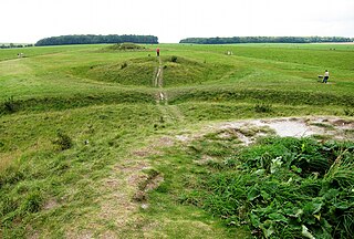
The Cursus Barrows is the name given to a Neolithic and Bronze Age round barrow cemetery located mostly south of the western end of the Stonehenge Cursus. The cemetery contains around 18 round barrows scattered along an east-to-west ridge, although some of the mounds are no longer visible. The Cursus Barrows can be seen just north of the route between the Stonehenge Visitor Centre and Stonehenge.

Drove Cottage Henge is a Scheduled Ancient Monument in the Priddy parish of Somerset, England. It is located 370 metres (1,210 ft) north of Drove Cottage. The site is a ceremonial Neolithic location. Since this henge is one of only around 80 henges throughout England, it is considered to be nationally important.

Fin Cop is a hill and an associated Iron Age hill fort in Monsal Dale, close to Ashford in the Water in Derbyshire, England.

Blaxhall Common is a nature reserve in the parish of Blaxhall in the Suffolk Coastal district of Suffolk. The reserve is owned by Blaxhall Parish Council and managed by Suffolk Wildlife Trust. It is designated a 45.9 hectare biological Site of Special Scientific Interest as Blaxhall Heath. It is part of the Sandlings Special Protection Area under the European Union Directive on the Conservation of Wild Birds, and of the Suffolk Coast and Heaths Area of Outstanding Natural Beauty. A Bronze Age bowl barrow is a Scheduled Monument.
Lidstone is a hamlet on the River Glyme in Oxfordshire, about 3 miles (5 km) east of Chipping Norton. The hamlet is in Enstone civil parish, about 1 1⁄4 miles (2 km) west of Neat Enstone.

Mendip is a local government district of Somerset in England. The Mendip district covers a largely rural area of 285 square miles (738 km2) ranging from the Mendip Hills through on to the Somerset Levels. It has a population of approximately 110,000. The administrative centre of the district is Shepton Mallet but the largest town is Frome.

The Gaulstown Portal Tomb or Gaulstown Dolmen is a megalithic portal tomb situated in Gaulstown, Butlerstown in County Waterford in the Republic of Ireland. It lies about 7 km south west of Waterford City.

Mountfortescue Hillfort is a National Monument consisting of a hillfort with tumuli located in County Meath, Ireland.

Carrickdexter Cross is a wayside cross and National Monument located in County Meath, Ireland.
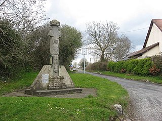
Athcarne Cross, also called Gaulstown Cross or the White Cross, is a wayside cross and National Monument located in County Meath, Ireland.


