
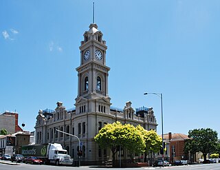
Geelong City Hall is a civic building located on Gheringhap Street in central Geelong, Victoria. It was originally built for the City of Geelong, which became the City of Greater Geelong in 1993. [1]
Geelong City Hall is a civic building located on Gheringhap Street in central Geelong, Victoria. It was originally built for the City of Geelong, which became the City of Greater Geelong in 1993. [1]
The land for the City Hall was first acquired by the council in 1854. Two acres (0.8 hectares) in size, it was on the corner of Little Malop and Gheringhap Streets. A design competition was held, with 12 entries being received. The winning entry was submitted by a Melbourne architect, Joseph Reed.
The cost was estimated at 34,533 pounds ($69,066), it was decided to only build a single southern wing along Little Malop Street. The foundation stone was laid on April 9, 1855 by the then-Mayor Dr William Baylie. The wing was completed soon after.

The single southern wing remained alone until the early 1900s. Suggestions were made to move the Town Hall to another site, with a referendum being held in 1914 proposing the council move to the former Geelong Grammar building on Moorabool Street. This proposal was defeated, with the original design being completed, opening in June 1917. It remains today, with minor additions at the rear.

Geelong is a port city in Victoria, Australia, located at the eastern end of Corio Bay and the left bank of Barwon River, about 65 km (40 mi) southwest of Melbourne.
The Upfield Shared Path is a shared use path for cyclists and pedestrians, which follows Upfield railway line through the inner northern suburbs of Melbourne, Victoria, Australia.

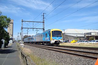
North Geelong is a suburb of Geelong in the Australian state of Victoria. The suburb was bypassed by traffic from Melbourne coming from the Princes Freeway by the creation of the Geelong Ring Road, which was complete in 2009. At the 2016 census, North Geelong had a population of 2,966.
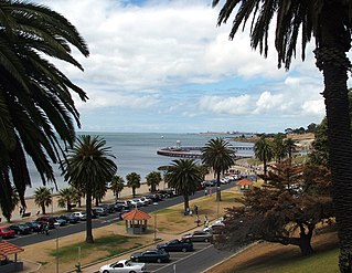
Eastern Beach is a popular swimming and recreation area in Geelong, Victoria on the shores of Corio Bay. Built during the 1930s in the Art Deco style, a shark proof sea bath is provided, as well as a children's swimming pool, kiosk, and dressing room pavilion. A number of Art Deco buildings in the area are listed on the Victorian Heritage Register.

Westfield Geelong is a shopping centre located in the Geelong CBD in Victoria, Australia which was opened in 1988. It was formerly known as Westfield Bay City before the 2008 redevelopment, and as Bay City Plaza before being acquired by the Westfield Group in 2003. The centre is located on the northern side of Malop Street opposite the Market Square shopping complex, and is bounded by Moorabool Street, Yarra Street, Malop Street and Brougham Street. The centre has completed its major redevelopment, including the expansion over Yarra Street via a flyover.

Market Square was a town square located in the centre of Geelong, Victoria, Australia. Consisting of eight acres of land, the area was reserved by Governor Sir George Gipps as a town square during the initial surveying of Geelong. The area later became a produce market, before being progressively built upon. Today the Market Square Shopping Centre occupies the site, having been opened in 1985 by the City of Geelong.

The Coburg Town Hall, formerly the Town Hall of the City of Coburg, is located on Bell Street, Coburg, Melbourne, Australia.

Brisbane City is the central suburb and central business district of Brisbane, the state capital of Queensland, Australia. It is colloquially referred to as the "Brisbane CBD" or "the city". It is located on a point on the northern bank of the Brisbane River, historically known as Meanjin, Mianjin or Meeanjin in the local Aboriginal Australian dialect. The triangular shaped area is bounded by the median of the Brisbane River to the east, south and west. The point, known at its tip as Gardens Point, slopes upward to the north-west where the city is bounded by parkland and the inner city suburb of Spring Hill to the north. The CBD is bounded to the north-east by the suburb of Fortitude Valley. To the west the CBD is bounded by Petrie Terrace, which in 2010 was reinstated as a suburb.
94.7 The Pulse, is a community radio station which broadcasts to the region of Geelong, Victoria, Australia.

St Kilda Town Hall is a grand, classically styled city hall, located on the corner of Brighton Road and Carlisle Street in St Kilda, Victoria, Australia. The first stage, never completed, was built as the municipal offices and public hall for the former City of St Kilda in 1890. Many additions, internal alterations, and changes in appearance were made in the early and mid 20th century, while serving as the municipal and social heart of St Kilda. A devastating fire in 1991 seriously affected the art collection and burnt out the hall itself, and was followed by a prize winning refurbishment and further extension. After Council amalgamations in 1994, it became the base for the larger City of Port Phillip, and further extensions and renovations have occurred. The hall within remains popular for numerous social events, meetings and performances, a role it has served for over 120 years.

Market Square Shopping Centre is located in Geelong, Victoria, Australia. The shopping centre was named after the original town square of Geelong on which the shopping centre is constructed. The centre is surrounded by Little Malop, Moorabool, Malop, and Yarra Streets. Market Square is located on the southern side of Malop Street opposite the Westfield Geelong shopping complex, the two of which together make up Geelong's Central Shopping Complex.

The Geelong Art Gallery, currently known as Geelong Gallery, is a major regional gallery in the city of Geelong in Victoria, Australia. The gallery has over 6,000 works of art in its collection. The Gallery forms Geelong's Cultural Precinct with the adjacent Geelong Library and Heritage Centre, Geelong Arts Centre, and the Geelong Courthouse.
The current Geelong Post Office opened in 1994 and is located on the corner of Gheringhap and Little Myers Streets. The original post office was located on the corner of Ryrie and Gheringhap Streets. The Geelong Telegraph Station was located next door.

Johnstone Park is a landscaped garden in Geelong, Victoria, Australia. It is bounded by Railway Terrace, Gheringhap Street, Little Malop Street, Fenwick Street, and Mercer Street. The park is surrounded by civic buildings including the Geelong City Hall, Geelong Art Gallery, Geelong Library, Geelong Law Courts, and the Geelong Railway Station. A war memorial and bandstand feature in the centre of the park.

Geelong Arts Centre, formerly the Geelong Performing Arts Centre (GPAC), is a performing arts, functions, and events venue located in Geelong, Victoria, Australia. The complex is located between Little Malop and Ryrie Streets in central Geelong, and comprises a number of venues. It also hosts Creative Engine, a sector of the organisation that runs programs such as Community Fuel.
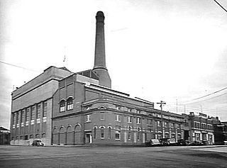
The city of Geelong, Victoria, Australia was once home to two coal-fired power stations - Geelong A and Geelong B.

The Geelong Waterfront is a tourist and recreation area on the north facing shores of Corio Bay in Geelong, Australia. The area was once part of the Port of Geelong, falling into disuse before being redeveloped during the 1990s.

Osborne House is a historic building built in 1858, located in North Geelong, Victoria, Australia.

The City of Geelong West was a local government area about 5 kilometres (3 mi) west of the regional city of Geelong, Victoria, Australia. The city covered an area of 5.26 square kilometres (2.0 sq mi), and existed from 1875 until 1993.
The Geelong–Ballarat railway line is a broad-gauge railway in western Victoria, Australia between the cities of Geelong and Ballarat. Towns on the route include Bannockburn, Lethbridge, Meredith, Elaine and Lal Lal. Major traffic includes general freight from the Mildura line, and grain.