Related Research Articles

Hol is a municipality in Buskerud county, Norway.
Botne is a former municipality in Vestfold county, Norway.
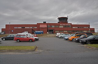
Skien Airport, Geiteryggen is a regional airport located at Geiteryggen, 5.5 kilometers (3.4 mi) southwest of the city center of Skien, Norway. Owned by Skien Municipality, it was last served by Widerøe with daily flights to Bergen. The runway is 1,416-by-30-meter and numbered 01–19. The airport had 33,080 passengers in 2014 and has Grenland and the southern part of Telemark as its catchment area.
Vildanden AS was a virtual, regional airline based at Skien Airport, Geiteryggen in Norway, where it was the only airline. With operations starting in 2005, it flew to Bergen, Trondheim and Stavanger using a Jetstream 32 and an ATR 42, which is wet leased from Danish Air Transport (DAT) and Helitrans. Previously, the airline has also served Stockholm and Molde, and has also operated Saab 340 aircraft, operated by Coast Air, Air Aurora and Avitrans. The airline had been in conflict with Coast Air about terminating the wet lease agreement. The company has had to be bailed out several times, including by the municipality, until it managed to make its first profit in 2009. It ceased operations and filed for bankruptcy in January 2011.

Aurlandsdalen is a glacially-formed Norwegian valley that is about 40 kilometres (25 mi) in length (Geiteryggen-Vassbygdi). The valley is situated in Aurland Municipality in Vestland county, to the south of the Sognefjorden. One of the best-known tourist tracks in Norway follows the valley from Geiteryggen just across the border of Hol Municipality and north east to Aurlandsvangen at the Aurlandsfjorden in Sogn. The valley narrows and becomes a tight, dramatic Western Norway valley. It combines glacially carved valleys with diverse plant species, and a number of cultural monuments in the form of old farms and mountain dairy farms to form a recognized tourist attraction. The richness in plant species is due to both the soil, rich in minerals formed from phyllite in the rocks and cultural influence through the centuries.
Fjellfly was a Norwegian airline which operated between 1954 and 1972. The airline was based at Skien Airport, Geiteryggen and served a diverse range of general aviation activities and a limited scheduled services. Major undertakings included distribution of the newspaper Dagbladet, flying tourists into mountainous areas such as Hardangervidda and crop dusted forest areas. A scheduled service was introduced from Skien to Oslo Airport, Fornebu in 1963, and was extended to Sandefjord Airport, Torp and Hamar Airport, Stafsberg four years later. At its peak in 1965, the airline had a fleet of fourteen aircraft.

Morales is a town and municipality in the Cauca Department, Colombia.
Vest-Telemark Airport, Fyresdal is an airport in Fyresdal municipality in Vestfold og Telemark, Norway. It does not service commercial aircraft. Was until 2008 operated by Airparc Fyresdal and in a joint venture with a local hotel. From 2009 operated by the local aeroclub and Fyresdal kommune. It has a declared runway length of 800 meters (2,600 ft), although the physical length is 1,400 meters (4,600 ft).

Waldheim is a town of 1,035 residents in the Rural Municipality of Laird No. 404, in the Canadian province of Saskatchewan, 57 kilometres (35 mi) north of Saskatoon. Waldheim is located on Highway 312 in central Saskatchewan, the "Heart of the Old North-Wes". Fort Carlton, Batoche, Battle of Fish Creek, and Seager Wheeler's Maple Grove Farm are all near Waldheim.

Ising Glacier is a glacier flowing northwest between Isingen Mountain and Kvitkjolen Ridge in the Sverdrup Mountains of Queen Maud Land, Antarctica. It was photographed from the air by the Third German Antarctic Expedition (1938–39). It was mapped by Norwegian cartographers from surveys and air photos by the Norwegian–British–Swedish Antarctic Expedition (1949–1952), led by John Schjelderup Giæver, and from air photos by the Norwegian expedition (1958–59) and named Isingbreen.
Ahlmann Ridge, also known as Ahlmannryggen, is a broad, mainly ice-covered ridge, about 110 km (70 mi) long, surmounted by scattered, low peaks. It rises between Schytt Glacier and Jutulstraumen Glacier and extends from Borg Massif northward to Fimbul Ice Shelf in Queen Maud Land. The area was first photographed from aircraft of the Third German Antarctic Expedition (1938–39) and peaks in this vicinity were roughly plotted. The Stein Nunataks and Witte Peaks, named by the German Antarctic Expedition, appear to coincide with the northeast part of the Ahlmann Ridge. The feature was mapped in detail from surveys and air photos by the Norwegian-British-Swedish Antarctic Expedition (NBSAE) (1949–1952) and air photos by the Norwegian expedition (1958–59). Named for Hans Wilhelmsson Ahlmann, chairman of the Swedish committee for the NBSAE.

Kolsås, sometimes called Kolsaas, is a hill in the municipality of Bærum, Norway. Geologically, Kolsås belongs to the Oslo Graben area. Its two peaks consist of hard rhomb porphyric lava covering softer rocks, forming steep cliffs to the east, south and west.
Léogâne is an arrondissement in the Ouest Department of Haiti. As of 2015, the population was 509,280 inhabitants. Postal codes in the Léogâne Arrondissement start with the number 62.
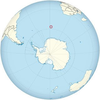
Bouvet Island is an island and dependency of Norway, and declared an uninhabited protected nature reserve. It is a subantarctic volcanic island, situated in the South Atlantic Ocean at the southern end of the Mid-Atlantic Ridge, and is the world's most remote island. It is not part of the southern region covered by the Antarctic Treaty System.
Norving A/S was a regional airline that operated in Norway between 1971 and 1993. It had roots back to the establishment of Varangfly in 1959. At its peak, the company had eight bases and 27 aircraft.
Teddy Air AS was a regional airline, based at Skien Airport, Geiteryggen, in Norway. Operating between 1989 and 2004, the company operated Britten-Norman Islander, Embraer 110 and Saab 340 aircraft. The company started by providing a scheduled service between Skien and Oslo in 1990, followed by services to Stavanger in 1993 and Bergen in 1994. In 1996, it won a contract with the Ministry of Transport from Oslo to Fagernes. It was involved in intense competition with other regional airlines, notably Coast Air and Guard Air, following the deregulation of the aviation market. It also had a single international service to Gothenburg, and from 1999 it served Stord Airport, Sørstokken. From 1999, the company was transformed to a virtual airline, which wet leased aircraft from Golden Air. The company ceased operations in 2004.
Jutulstraumen Glacier is a large glacier in Queen Maud Land, Antarctica, about 120 nautical miles (220 km) long, draining northward to the Fimbul Ice Shelf between the Kirwan Escarpment, Borg Massif and Ahlmann Ridge on the west and the Sverdrup Mountains on the east. It was mapped by Norwegian cartographers from surveys and air photos by the Norwegian–British–Swedish Antarctic Expedition (1949–52) and air photos by the Norwegian expedition (1958–59) and named Jutulstraumen. More specifically jutulen are troll-like figures from Norwegian folk tales. The ice stream reaches speeds of around 4 metres per day near the coast where it is heavily crevassed.
Åsen is a neighborhood divided between the boroughs of Sagene and Nordre Aker in Oslo, Norway.

Ahmadkhel District or Lazha Ahmadkhel is a district of Paktia Province, Afghanistan.
Nordporten is the northern part of Hinlopen Strait, Svalbard. It extends from a northern line between Langgrunnodden and Verlegenhuken, to a southern line between the headlands of Tvillingneset and Basisodden. Nordporten has a width of about fifteen nautical miles at the mouth between Storsteinhalvøya and Mosselhalvøya. Further south it narrows to about five nautical miles.
References
- ↑ Godal, Anne Marit (ed.). "Geiteryggen". Store norske leksikon (in Norwegian). Oslo: Norsk nettleksikon. Retrieved 4 July 2014.
59°01′42″N11°38′02″E / 59.0283°N 11.6339°E
| | This article about a mountain, mountain range, or peak in Buskerud is a stub. You can help Wikipedia by expanding it. |