
Lüdenscheid is a city in the Märkischer Kreis district, in North Rhine-Westphalia, Germany. It is located in the Sauerland region.

Prenzlau is a town in Brandenburg, Germany, the administrative seat of Uckermark District. It is also the centre of the historic Uckermark region.

Mühlacker is a town in the eastern part of the Enz district of Baden-Württemberg, Germany. Mühlacker station has direct rail connections with Stuttgart, Karlsruhe, Heidelberg, Pforzheim and the Northern Black Forest.

Weihenstephan is a part of Freising north of Munich, Germany. It is located on the Weihenstephan Hill, named after the Weihenstephan Abbey, in the west of the city.
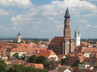
Straubing is an independent city in Lower Bavaria, southern Germany. It is seat of the district of Straubing-Bogen. Annually in August the Gäubodenvolksfest, the second largest fair in Bavaria, is held.

Weiden in der Oberpfalz is a district-free city in Bavaria, Germany. It is located 100 km (62 mi) east of Nuremberg and 35 km (22 mi) west of the Czech border. Weiden is the second biggest city in the governmental district Oberpfalz, next to Regensburg. A branch of the German Army is located here.
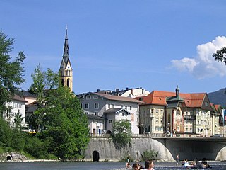
Bad Tölz is a town in Bavaria, Germany and the administrative center of the Bad Tölz-Wolfratshausen district.

Tsalka is a town and municipality center in southern Georgia's Kvemo Kartli region.

Weißenburg in Bayern, formerly also Weißenburg im Nordgau, Weißenburg am Sand, is a town in Middle Franconia, Germany. It is the capital of the district Weißenburg-Gunzenhausen. In 2020 its population was 18,578. Weißenburg was a free imperial city for 500 years.

Monte Sant'Angelo is a town and comune of Apulia, southern Italy, in the province of Foggia, on the southern slopes of Monte Gargano. It is a member of the I Borghi più belli d'Italia association.

Damghan is a city in, and the capital of, the Central District of Damghan County, Semnan province, Iran, and also serves as capital of the county.

Tholey is a municipality in the district of Sankt Wendel, in Saarland, Germany. It is situated approximately 10 kilometres (6.2 mi) west of Sankt Wendel, and 30 kilometres (19 mi) north of Saarbrücken.

Morombe is an urban municipality on the south-west coast in Atsimo-Andrefana, Madagascar. It can be reached by the National road 55 or pirogue from Morondava. It is situated at 283 km from Tulear.

Boľkovce is a village and municipality in the Lučenec District in the Banská Bystrica Region of Slovakia.

Mesocco is a municipality in the Moesa Region in the Swiss canton of Graubünden.

Dolný Hričov is a village and municipality in Žilina District in the Žilina Region of northern Slovakia.

Lautertal is a municipality in the district of Coburg in Bavaria in Germany. Near Lautertal, there was between 1952 and 1992 a DECCA-transmitter.

Hohenpeißenberg is a municipality in the Weilheim-Schongau district, in Bavaria, Germany. Hohenpeißenberg is situated in the Bavarian Oberland, in the Alpine Foreland.

Fürstenzell is a municipality in the district of Passau in Bavaria in Germany.

Mahanoro is a rural municipality located in the Atsinanana region of eastern Madagascar, along the coast.