Related Research Articles

Dawit II, also known by the macaronic name Wanag Segad, better known by his birth name Lebna Dengel, was Emperor of Ethiopia from 1508 to 1540, whose political center and palace was in Shewa.
Na'od was Emperor of Ethiopia from 1494 to 31 July 1507, and a member of the Solomonic dynasty. His regnal name was Anbasa Bazar. His reign was marked by internal tension between territories with the assistance of Queen Eleni. He began construct an extravagant church in Amhara province, called Mekane Selassie. The church was completed by his successor Dawit II in 1530.
Newaya Krestos was Emperor of Ethiopia from 1344 to 1372, and a member of the Solomonic dynasty. He was the eldest son of Amda Seyon I.
Mahfuz was a Garad, Emir of Harar and Governor of Zeila in the Adal Sultanate. Although he was originally only emir of a small region he would rise to become leader of Adal due to his popularity, wielding more power than the sultan of Adal. He is often known as the "Captain of Zeila" in medieval texts.
Negash is a village in the Tigray Region of Ethiopia, which straddles the Adigrat to Mekelle road 10 kilometres north of Wukro. It is located in Wukro woreda.

Lake Hayq is a freshwater lake of Ethiopia. It is located north of Dessie, in the Debub Wollo Zone of the Amhara Region. The town of Hayq is to the west of the lake.

Istifanos Monastery is a monastery in Ethiopia, located in Lake Hayq. The church structure was built around the 9th century by the Aksumite king Dil Na'od. In the 13th century, the church was converted into a monastery, in large part due to the work of Saint Iyasus Mo'a and later Emperor Yekuno Amlak.
Dembiya is a historic region of Ethiopia, intimately linked with Lake Tana. According to the account of Manuel de Almeida, Dembiya was "bounded on East by Begemder, on South by Gojjam, on West by Agaws of Achefer and Tangha. Lake Tsana, formerly called Dambaya, is in this region."The region included the current woredas of Dembiya, Gondar zuriya, Libo Kemkem, Fogera, Dera. Takusa and Alefa. Dembiya encircled more than 89% of lake Tana. The region was governed by Ahmed ibn Ibrahim al-Ghazi and also served well as his personal residence and seat of government during the Ethiopian-Adal War. The rest of the province was divided among the Adalite soldiers while the native Amhara population served as peasant farmers. Alexander Murray, in his preface to the third volume of Bruce's account, further describes it as "on the east it includes Foggora, Dara, and Alata; on the north-east Gondar, the metropolis, and the rich district beneath it; on the southwest, the district of Bed and, on the west, the lands around Waindaga and Dingleber."
Muhammad ibn Badlay was a Sultan of the Sultanate of Adal. He was the son of Badlay ibn Sa'ad ad-Din. During his reign the Adalite ruler Muhammad and the Solomonic ruler Baeda Maryam agreed to a truce and both states in the following decades saw an unprecedent period of peace and stability.
Muhammad ibn Azhar ad-Din was a Sultan of the Adal Sultanate. Sihab ad-Din Ahmad states in his Futuh al-Habasha that he was the son of Azhar, the second son of Abu Bakr, one of the ten sons of Sa'ad ad-Din II, and ruled for 30 years.
ʿUmar Dīn, , was a Sultan of the Adal Sultanate in the Horn of Africa. He was the younger brother of Abu Bakr ibn Muhammad. According to historian Richard Pankhurst, Umar was of Harari background.
The Battle of Shimbra Kure was fought on 9 March 1529 between the forces of Adal led by Imam Ahmad ibn Ibrahim al-Ghazi, and the Abyssinian army, under Dawit II. It was the first major battle of the Ethiopian–Adal War.
The Battle of Antukyah was fought in 1531 between Adal Sultanate forces under Imam Ahmad ibn Ibrahim al-Ghazi and the Abyssinian army under Eslamu. Huntingford has located Antukyah about 89 kilometres south of Lake Hayq, at the edge of the Ethiopian Highlands, in the modern district of Antsokiya and Gemza.
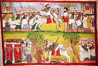
The Ethiopian–Adal War, also known as the Abyssinian–Adal War and Futūḥ Al-Ḥabaša, was a war fought between the Christian Ethiopian Empire and the Muslim Adal Sultanate from 1529 to 1543. The Christian Ethiopian troops consisted of the Amhara, Tigrayans, Tigrinya and Agaw people, and at the closing of the war, supported by the Portuguese Empire with no less than four hundred musketeers. The Adal forces were composed of Harla, Somali, Afar, as well as Arab and Turkish gunmen. Both sides would see the Maya mercenaries at times join their ranks.

Mojo is a town in central Ethiopia, named after the nearby Modjo River. Located in the East Shewa Zone of the Oromia Region, it has a latitude and longitude of 8°39′N39°5′E with an elevation between 1788 and 1825 meters above sea level. It is the administrative center of Lome district.
Sharkha was a province of the Ethiopian Empire in the southern part of its realm. Its inhabitants were predominantly Muslim, and similar in customs, economic conditions, and ethnic affiliations to its neighboring provinces of Hadiya, Oromo and Arababni.
The Gaturi, also spelled as Gatouri are an extinct ethnic group that once inhabited present-day eastern Ethiopia.
Ahmed Girri Bin Hussein was a Somali military commander and general that served the Adal Sultanate. He played a very prominent role in the campaigns of Ahmad ibn Ibrahim al-Ghazi by bringing one of the largest armies to aid the Imam in Jihad. Ahmed Girri hailed from the Yabarray clan. He was also the chieftain of Habr Maqdi which was a collective of Yabarray and Bartire. He was regarded one of the most capable generals during the Conquest of Abyssinia alongside Garad Matan.

The Habr Maqdi was a historical Somali confederation that composed of multiple clans such as the Bartire and Yabarre who are considered now a part of the Jidwaaq and come under the Absame Darod branch. The Habr Maqdi are well known for their conquests in Abyssinia as they had played a very prominent role in Ethiopian-Adal War. They are famous for bringing the largest army and were very loyal to Imam Ahmed. Richard Burton documented the Bartire branch of Habr Maqdi to have long been connected with the emirs of Harar. Both sub-clans of Habr Maqdi are mentioned explicitly in Futuh al-Habesh.
Robēl was a general and governor in the Ethiopian Empire under Lebna Dengel. He was killed in The Battle of Shimbra Kure.
References
- ↑ R.E. Cheesman, "Lake Tana and Its Islands", Geographical Journal, 85 (1935), p. 500
- ↑ Sihab ad-Din Ahmad bin 'Abd al-Qader, Futuh al-Habasa: The conquest of Ethiopia, translated by Paul Lester Stenhouse with annotations by Richard Pankhurst (Hollywood: Tsehai, 2003), pp. 383f
| | This article about a location in the Amhara Region of Ethiopia is a stub. You can help Wikipedia by expanding it. |