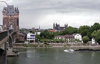
Worms is a city in Rhineland-Palatinate, Germany, situated on the Upper Rhine about 60 km (40 mi) south-southwest of Frankfurt am Main. It had about 84,646 inhabitants as of 2022.

Krefeld, also spelled Crefeld until 1925, is a city in North Rhine-Westphalia, Germany. It is located northwest of Düsseldorf, its center lying just a few kilometers to the west of the river Rhine; the borough of Uerdingen is situated directly on the Rhine. Because of its economic past, Krefeld is often referred to as the "Velvet and Silk City". It is accessed by the autobahns A57 (Cologne–Nijmegen) and A44 (Aachen–Düsseldorf–Dortmund–Kassel).

The Franks were a group of several related Germanic peoples who originally inhabited the northern and eastern banks of the fortified Roman border (Limes) along the northernmost stretches of the river Rhine. The Romans only began to refer to these tribes as Franks in the third century AD. In the fourth century the Roman also began to distinguish tribes further north with another new collective term "Saxons", although there are signs that the terms Frank, Saxon were not always mutually exclusive in the earliest period. The Franks lived for centuries under Roman hegemony, as the long-term neighbours of Germania Inferior, which was the most northerly Roman province in continental Europe, and contained much of what is now the Netherlands, the German Rhineland, and Belgium. Over centuries, the Romans recruited large numbers of Frankish soldiers, some of whom achieved high imperial rank.

Erkelenz is a town in the Rhineland in western Germany that lies 15 kilometres southwest of Mönchengladbach on the northern edge of the Cologne Lowland, halfway between the Lower Rhine region and the Lower Meuse. It is a medium-sized town and the largest in the district of Heinsberg in North Rhine-Westphalia.

Rees is a town in the district of Kleve in the state of North Rhine-Westphalia, Germany. It is located on the right bank of the Rhine, approximately 20 km east of Kleve. The population in 2005 was 22,559. Founded in 1228, Rees is the oldest town in the lower Rhine area.

Vetera was the name of the location of two successive Roman legionary camps in the province of Germania Inferior near present-day Xanten on the Lower Rhine. The legionary camps of Vetera were part of the Lower Germanic Limes and were declared a UNESCO World Heritage Site in 2021.
Zons, formerly known as Feste Zons(Fortress Zons), today officially called Stadt Zons is an old town in Germany on the west bank of the Lower Rhine between Cologne and Düsseldorf. It has been a part (Stadtteil) of the town of Dormagen since 1975. In 2020 its population was 5,452.

Bonn Minster is a Catholic church in Bonn. It is one of Germany's oldest churches, having been built between the 11th and 13th centuries. At one point the church served as the de facto cathedral for the Archbishopric of Cologne, because it is the major church of what was then the Archbishop-Elector's residence. It is now a minor basilica. It served as the inspiration for the Kaiser Wilhelm Memorial Church in Berlin, as Kaiser Wilhelm II had studied in Bonn.

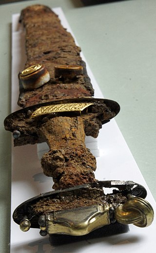
The Migration Period sword was a type of sword popular during the Migration Period and the Merovingian period of European history, particularly among the Germanic peoples. It later gave rise to the Carolingian or Viking sword type of the 8th to 11th centuries AD.

The Keszthely culture was a mixed Romanised population-Germanic-Avar, Christian enclave located in present-day Hungary, from the 6th century until the first half of the 7th century. These people could be found near the northern part of Lake Balaton and around Keszthely in a roughly 30 km area. The culture had faded out by the 7th century.

Bruchweiler is an Ortsgemeinde – a municipality belonging to a Verbandsgemeinde, a kind of collective municipality – in the Birkenfeld district in Rhineland-Palatinate, Germany. It belongs to the Verbandsgemeinde Herrstein-Rhaunen, whose seat is in Herrstein.

Sörgenloch is an Ortsgemeinde – a municipality belonging to a Verbandsgemeinde, a kind of collective municipality – in the Mainz-Bingen district in Rhineland-Palatinate, Germany.
Joachim Werner was a German archaeologist who was especially concerned with the archaeology of the Early Middle Ages in Germany. The majority of German professorships with particular focus on the field of the Early Middle Ages were in the second half of the 20th century occupied by his academic pupils.

Pingsdorf ware is a high fired earthenware, or proto-stoneware, that was produced between the late 9th and 13th century in different pottery centres on the Eastern margin of the Rhineland as well as the Lower Rhine region. Characteristic features of vessels in Pingsdorf ware are a yellow-coloured fine sand-tempered sherd and a red painting. It is archaeologically evident within various Medieval settlements of North Western Europe and thus represents an important chronological marker for the Medieval archaeology.

Orsoy [ˈɔʁzaʊ̯], from approximately 1273 to 1974 an independent town, most recently within the Kreis Moers district, is today a district and one of four boroughs of the North Rhine-Westphalian town of Rheinberg on the left bank of the Lower Rhine in the Kreis Wesel district.

The Lower Germanic Limes is the former frontier between the Roman province of Germania Inferior and Germania Magna. The Lower Germanic Limes separated that part of the Rhineland left of the Rhine as well as the southern part of the Netherlands, which was part of the Roman Empire, from the less tightly controlled regions east of the Rhine.

Rheindahlen is a town in the western and largest borough of the city of Mönchengladbach in the German state of North Rhine-Westphalia. Since the reorganisation of Monchengladbach's boroughs (Stadtbezirke) on 22 October 2009 Rheindahlen has been part of Mönchengladbach West. From the granting of Nideggen town rights in 1354 until the incorporation of the mayoralty of Rheindahlen into M.-Gladbach on 30 June 1921, the place was an independent town.

Moritz Leiffmann was a German private banker, local politician, writer and art collector.

Johannisberg is a prominent ridge of the Wöllmisse, a Muschelkalk plateau east of Jena. The steeply sloping spur of land to the Saale Valley north of the district of Alt-Lobeda bears the remains of two important fortifications from the late Bronze Age and the early Middle Ages. Due to several archaeological excavations and finds recovered since the 1870s, they are among the few investigated fortifications from these periods in Thuringia. Of particular interest in archaeological and historical research is the early medieval castle. Due to its location directly on the eastern bank of the Saale, its dating and interpretation were and are strongly linked to considerations of the political-military eastern border of the Frankish empire. It is disputed whether it was a fortification of independent Slavic rulers or whether it was built under Frankish rule. According to a recent study, it may have been built in the second half of the 9th century in connection with the establishment of the limes sorabicus under Frankish influence.
Waagen und Gewichte aus dem mittelalterlichen Schleswig. Funde des 11. bis 13. Jahrhunderts aus Europa als Quellen zur Handels- und Währungsgeschichte is a 1997 monograph by Heiko Steuer.


