
Tyrone Township is a township that is located in Adams County, Pennsylvania, United States. The population was 2,298 at the time of the 2010 census.

Mount Pleasant is a neighborhood in Newark in Essex County, in the U.S. state of New Jersey. It is east of Branch Brook Park and north of the Lower Broadway neighborhood. It is named for the hill overlooking the Passaic River on which it rests.
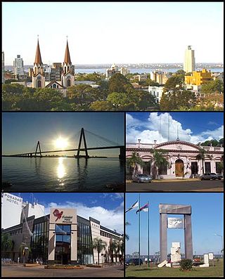
Posadas is the capital city of the Argentine province of Misiones, in its south, at the far north-west of the country on the left bank of the Paraná River, opposite Encarnación, Paraguay. The city has an area of 965 square kilometres (373 sq mi) and a population of 324,756, and the Greater Posadas area has a population of over 359,609 according to a 2017 estimate.

Reducción de Santa María la Mayor, located in the Santa María Department of the Misiones Province, Argentina, at approximate coordinates 27°33′S55°20′W, was one of the missions or reductions founded in the 17th century by the Jesuits in the Americas during the Spanish colonial period. In 1984 it was one of four reduction sites in Argentina designated as World Heritage Sites by UNESCO.

The Roman Catholic Diocese of Posadas is a Catholic diocese located in the city of Posadas, Misiones in the ecclesiastical province of Corrientes in Argentina.
Bokaa is a village in Kgatleng District of Botswana. The village is located around 20 km south-west of Mochudi and the population was 5,765 in 2011 census. The village is just north of the Bokaa Dam.

The National University of Misiones is a public university in Argentina. It has a publishing house and a radio station, LRH301 FM Universidad Nacional de Misiones, that streams in Ogg Vorbis format.

Almafuerte is a village and municipality in Misiones Province in north-eastern Argentina. The village is located in the Leandro N. Alem department, and borders Leandro N. ALem, Caá Yarí, Olegario Víctor Andrade and Bonpland municipalities. It has a population of 1022 inhabitants.

Garupá is a village and municipality in Misiones Province in north-eastern Argentina. It takes part of the Great Posadas, and most of the population works in the provincial capital.

Gobernador López is a village and municipality in Misiones Province in north-eastern Argentina.
Gobernador Roca is a village and municipality in Misiones Province in north-eastern Argentina.

Guaraní (Misiones) is a village and municipality in Misiones Province in north-eastern Argentina.

Hipólito Yrigoyen (Misiones) is a village and municipality in Misiones Province in north-eastern Argentina.

Jardín América is a village and municipality of Misiones Province in north-eastern Argentina. It is not the head city of the San Ignacio department, however, it is the largest city in the department. It is located 1,141 km north of Buenos Aires and 104 km from Posadas, on the eastern shore of the Paraná River.
Wichí – El Pintado is a village and municipality in Chaco Province in northern Argentina.

Amahlathi Municipality is a local municipality within the Amatole District Municipality, in the Eastern Cape province of South Africa. Amahlati is an isiXhosa word meaning "a place where many trees are grouped together, a forest". Forests are a key feature of the area.
Landis Store is a village in District Township, Berks County, Pennsylvania, United States. It is drained by the West Branch Perkiomen Creek into the Perkiomen Creek in the Green Lane Reservoir. It is split between the Alburtis zip code of 18011, the Barto zip code of 19504, and the Boyertown zip code of 19512.
Hamley Run is an unincorporated community in Athens County, in the U.S. state of Ohio.
The Mescal Mountains are a series of connected mountain ridges in southern Gila County, Arizona. Their highest point is El Capitan Mountain, which has an elevation of 6,568 ft and a prominence of 1,828 ft. The highest point has a topographic isolation of 5.98 miles, with the nearest point of equal or greater elevation being to the north west in the Pinal Mountains. The mountain ridges are visible in the east from Arizona State Route 77 between Globe and Winkelman.The range is approximately 10 miles west of San Carlos Lake, which lies in the San Carlos Apache Indian Reservation; the ridges themselves also mostly fall within the boundary of the reservation, with the exception of the western section and the high point. As such, hiking the ridge may require special permission from San Carlos Apache Indian Reservation, although no trails exist on the mountains themselves or leading to them. The ridge's relative proximity to the more visually dominant Pinal Mountains, make it an often-overlooked feature. The range is one of many to occur in the Arizona transition zone.
