
The Arctic Archipelago, also known as the Canadian Arctic Archipelago, is an archipelago lying to the north of the Canadian continental mainland, excluding Greenland and Iceland.
This article describes the composition and actions of the Argentine naval forces in the Falklands War. For a list of naval forces from the United Kingdom, see British naval forces in the Falklands War.

This is a list of the extreme points of Ireland – the points that are farthest north, south, east or west in Ireland. It includes the Republic of Ireland and Northern Ireland.
New York Airways was an American helicopter airline in the New York City area, founded in 1949 as a mail and cargo carrier. On 9 July 1953 it may have been the first scheduled helicopter airline to carry passengers in the United States, with headquarters at LaGuardia Airport. Although primarily a helicopter airline operator with scheduled passenger operations, New York Airways also flew fixed wing aircraft, such as the de Havilland Canada DHC-6 Twin Otter 19-passenger STOL twin turboprop aircraft.

SS 433 is a microquasar or eclipsing X-ray binary system, consisting of a stellar-mass black hole accreting matter from an A-type companion star. SS 433 is the first discovered microquasar. It is at the centre of the supernova remnant W50.
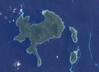
Nuakata Island is a small, mountainous island in the Goschen Strait south of Normanby Island and east of East Cape. It is part of Milne Bay Province in southeastern Papua New Guinea. Mount Tanorabwa is the highest point on the island at 1,072 feet.
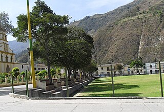
Panqueba is a town and municipality in the Colombian Department of Boyacá, part of the subregion of the Gutiérrez Province.

Mount Shattuck is a peak, 1,430 m, located at the south end of Independence Hills, about 3 miles (4.8 km) northwest of Redpath Peaks, in the Heritage Range. It was named by the Advisory Committee on Antarctic Names (US-ACAN) for aviation machinist Wayne M. Shattuck of the U.S. Navy, who was an air crewman on LC-47 aircraft, who perished in a crash on the Ross Ice Shelf on February 2, 1966.
Gopher Glacier is a glacier descending from Christoffersen Heights and draining north between Bonnabeau Dome and Anderson Dome, in the Jones Mountains of Antarctica. It was mapped and named by the University of Minnesota Jones Mountains Party, 1960–61; "Gopher" is the nickname of the University of Minnesota and of the State.

Ellenborough River, a perennial river of the Hastings River catchment, is located in the Mid North Coast region of New South Wales, Australia.
The Porthos Range is the second range south in the Prince Charles Mountains of Antarctica, extending for about 30 miles in an east-to-west direction between Scylla Glacier and Charybdis Glacier. First visited in December 1956 by the Australian National Antarctic Research Expeditions (ANARE) southern party under W.G. Bewsher (1956-57) and named after Porthos, a character in Alexandre Dumas, père's novel The Three Musketeers, the most popular book read on the southern journey.
Faletagaloa is a village on the central north coast of Savai'i island in Samoa.

Nobile Glacier is a glacier flowing into the southeast part of Recess Cove, Charlotte Bay, on the west coast of Graham Land. Charted by the Belgian Antarctic Expedition under Gerlache, 1897–99. it was photographed from the air by FIDASE and surveyed from the ground by Falkland Islands Dependencies Survey from Portal Point, 1956–58.
Wellman Glacier is a glacier flowing into the northeast part of Recess Cove, Charlotte Bay, on the west coast of Graham Land. Charted by the Belgian Antarctic Expedition under Gerlache, 1897–99. Named by the United Kingdom Antarctic Place-Names Committee (UK-APC) in 1960 for Walter Wellman (1858–1934), American Arctic explorer who attempted unsuccessfully to reach the North Pole in a semi-rigid airship in 1907 and 1909.
Muus Glacier is a glacier entering the north side of Odom Inlet between Snyder Peninsula and Strømme Ridge, on the east coast of Palmer Land. Mapped by the United States Geological Survey (USGS) in 1974. Named by Advisory Committee on Antarctic Names (US-ACAN) for David Muus, United States Antarctic Research Program (USARP) oceanographer aboard USCGC Northwind in the Ross Sea area, 1971–72, and a participant in the Weddell Sea Oceanographic Investigations aboard USCGC Glacier, 1974–75.
Eadie Island is an island 2 km (1.2 mi) long which lies between Aspland Island and O'Brien Island, in the South Shetland Islands of Antarctica. A strong marine channel, named Tasman Rip, runs between Eadie Island and O'Brien Island.
Ekho Mountain is a mountain, 1,690 metres (5,540 ft) high, standing 3 nautical miles (6 km) southwest of Vorposten Peak in the Lomonosov Mountains, Queen Maud Land. It was discovered and roughly plotted from air photos by the Third German Antarctic Expedition, 1938–39. It was mapped from air photos and surveys by the Sixth Norwegian Antarctic Expedition, 1958–59, was remapped by the Soviet Antarctic Expedition, 1960–61, and named "Gora Ekho".

Lardero is a village in the province and autonomous community of La Rioja, Spain. The municipality covers an area of 20.36 square kilometres (7.86 sq mi) and as of 2011 had a population of 8438 people.