
The Arctic Archipelago, also known as the Canadian Arctic Archipelago, is an archipelago lying to the north of the Canadian continental mainland, excluding Greenland and Iceland.

Águas Vermelhas is a city in the northeast of the Brazilian state of Minas Gerais. In 2020 its population was estimated to be 13,599 in a total area of 1,258 km².
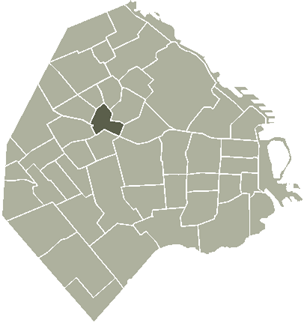
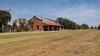
La Paternal or Paternal is a neighborhood or district in the centre of Buenos Aires city, Argentina. It was founded in 1904 by a city decree (decreto) and was named 'La Paternal' after the train station in the neighbourhood, a former industrial zone.

Rafael Bustillo is a province in the Bolivian Potosí Department. Its name honors the Bolivian diplomat and foreign secretary Rafael Bustillo. The capital of the province is Uncía with a population of 5,709 in the year 2001, the largest town is Llallagua with 20,065 inhabitants.
The Trojan Range is a mountain range rising to 2,760 metres (9,055 ft), extending northward from Mount Francais along the east side of Iliad Glacier, Anvers Island, in the Palmer Archipelago of the British Antarctic Territory. It was surveyed by the Falkland Islands Dependencies Survey (FIDS) in 1955 and named by the UK Antarctic Place-Names Committee (UK-APC) for the Trojans, one of the opposing sides in the Trojan War in Homer's Iliad.
Zephyr Glacier 1 is a glacier, about 8 miles (13 km) long, flowing westward from the southwest side of Mount Edgell into George VI Sound to the south of Cape Jeremy. The feature was surveyed by Falkland Islands Dependencies Survey (FIDS), 1948, and British Antarctic Survey (BAS), 1971–72; photographed from the air by U.S. Navy, 1966. Named by United Kingdom Antarctic Place-Names Committee (UK-APC) in 1977 after Zephyrus, the west wind. One of the several features in this area is named after winds.
Nansen Ice Sheet is a 30 nautical miles long by 10 nautical miles wide ice shelf. It is nourished by the Priestley and Reeves Glaciers and abuts the north side of the Drygalski Ice Tongue, along the coast of Victoria Land, Antarctica. This feature was explored by the South Magnetic Polar Party of the British Antarctic Expedition, 1907-09 and by the Northern Party of the British Antarctic Expedition, 1910-13. Frank Debenham, geologist with the latter expedition, applied the name Nansen Sheet as the feature is adjacent to Mount Nansen, the dominating summit in the area.
Rio Real is a municipality in the state of Bahia in the North-East region of Brazil. It is named for the nearby river.
Humberto de Campos is a municipality in the state of Maranhão in the Northeast region of Brazil. It is named after the Brazilian writer Humberto de Campos.
Vera Mendes is a municipality in the state of Piauí in the Northeast region of Brazil.
Lonquimay (La Pampa) is a village and rural locality (municipality) in La Pampa Province in Argentina.
Giesecke Glacier is a glacier in Avannaata municipality in northwestern Greenland. Its outflow is split in the center by a nunatak. Through two tongues it drains the Greenland ice sheet westwards into Kangerlussuaq Icefjord. The northern tongue reaches the fjord at 73°35′N55°36′W. The southern tongue reaches the fjord at 73°30′N55°28′W.
Barker Range is a mountain range trending northwest–southeast and including Jato Nunatak, Mount Watt, Mount McCarthy, and Mount Burton, located at the southwest side of the Millen Range in the Victory Mountains, Victoria Land, Antarctica. It was named by the New Zealand Antarctic Place-Names Committee (NZ-APC) for James Barker, leader at Scott Base, 1972.
Bertram Glacier is a glacier, 15 nautical miles (28 km) long and 18 nautical miles (33 km) wide at its mouth, which flows west from the Dyer Plateau of Palmer Land into George VI Sound between Wade Point and Gurney Point.
Triad Islands is a group of three small islands lying 1.5 nautical miles (2.8 km) east of Chavez Island, off the west coast of Graham Land. First charted by the British Graham Land Expedition (BGLE) under Rymill, 1934–37. The name given by the United Kingdom Antarctic Place-Names Committee (UK-APC) in 1959 is descriptive.
Patroclus Hill is a rounded, snow-covered hill, 760 m, separated by a low col from the northwest side of Mount Achilles in the Achaean Range of Anvers Island, in the Palmer Archipelago. Surveyed by the Falkland Islands Dependencies Survey (FIDS) in 1955 and named by the United Kingdom Antarctic Place-Names Committee (UK-APC) for Patroclus, the squire and close friend of Achilles in Homer's Iliad.

Mondor Glacier is a glacier 3.5 nautical miles (6 km) long flowing southwest from the head of Depot Glacier into Duse Bay, Trinity Peninsula, Antarctica. This glacier and Depot Glacier together fill the depression between Hope Bay and Duse Bay which marks the northern limit of Tabarin Peninsula. The glacier was mapped in 1946 and 1956 by the Falkland Islands Dependencies Survey (FIDS), who named the feature in association with Tabarin Peninsula. "Operation Tabarin" was derived from the "Bal Tabarin" in Paris. In Recueil General des Oeuvres et Fantaisies de Tabarin, Tabarin was the buffoon who attracted the crowd to the booth where Mondor sold his quack medicines.
Richardson Glacier is the broad northwest tributary to the Clifford Glacier, entering it just southeast of Mikus Hill in Palmer Land. Mapped by the United States Geological Survey (USGS) in 1974. Named by Advisory Committee on Antarctic Names (US-ACAN) after Harriet Richardson, French zoologist, author of a number of reports on the Crustacea (Isopoda) collected by the French Antarctic Expeditions of 1903-05 and 1908–10.

Quéntar is a municipality in the province of Granada, Spain. As of 2020, it has a population of 947 inhabitants.