
Genesee County is a county in the U.S. state of Michigan. As of the 2020 Census, the population was 406,211, making it the fifth-most populous county in Michigan. The county seat and population center is Flint. Genesee County is considered to be a part of the greater Mid Michigan area.
The Wachusett Reservoir is the second largest body of water in the state of Massachusetts. It is located in central Massachusetts, northeast of Worcester. It is part of the water supply system for metropolitan Boston maintained by the Massachusetts Water Resources Authority (MWRA). It has an aggregate capacity of 65 billion US gallons (250,000,000 m3) and an area of almost 7 square miles (18 km2). Water from the reservoir flows to the covered Norumbega Storage Facility via the Cosgrove Tunnel and the MetroWest Water Supply Tunnel. The reservoir has a maximum depth of 120 feet (37 m) and a mean depth of 48 feet (15 m).

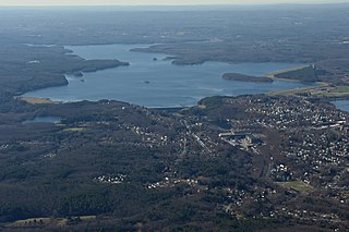
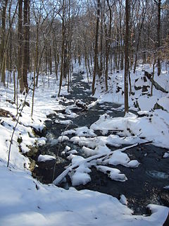
Lake Saltonstall, is a long narrow lake located in south-central Connecticut. It covers an area of approximately 0.66 square miles (1.7 km2) and is nestled in the center of the trap rock Saltonstall Mountain. The lake is surrounded by forest and serves as part of the local water supply for surrounding towns.
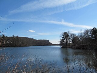
Lake Whitney is a lake in Hamden, Connecticut, that is a part of the Mill River. The lake was a water source for the New Haven, Connecticut, metro area, until its associated treatment plant became antiquated in the 1990s. A new water treatment facility was constructed in the early 2000s rated for up to 15 million gallons per day, Lake Whitney now serves as one of four primary sources of surface water for the RWASouth Central Connecticut Regional Water Authority. The construction of the new treatment plant was controversial, and the RWA conducted significant public outreach and environmental study prior to its approval. Concerns mainly focused on downstream release into the Mill River, and maintaining the lake at a resonable level. Because of this, the RWA agreed to a detailed management plan aimed a mitigating impacts on the Lake Whitney ecosystem. RWA also operates a gravity release from the dam when there is no flow over the spillway, and operates an "Eel Pass" in conjunction with CT DEEP to assist with eel migration over the dam.

Wilgus State Park is a state park in Ascutney, Vermont. The park offers canoeing along the Connecticut River and hiking up the Pinnacle Trail. The park has tent and lean-to sites and is quite close to Mount Ascutney and the Saint-Gaudens National Historic Site. The park was originally constructed by the Civilian Conservation Corps (CCC) and is now administered by the Vermont Department of Forests, Parks, and Recreation as part of the Vermont state park system. It is named after William J. Wilgus, who donated the land for the park in 1933. The park is listed on the National Register of Historic Places for its well-preserved CCC infrastructure.

University City (UC) is a community in San Diego, California, located in the northwestern portion of the city next to the University of California, San Diego. University City is bordered by La Jolla and Interstate 5 to the west, Miramar and Interstate 805 to the east, and North Clairemont and Highway 52 to the south, giving the community a triangular-shaped boundary. University City is a part of District 1, which is represented by Councilmember Joe LaCava on the San Diego City Council.
The Ware River is a 35.4-mile-long (57.0 km) river in central Massachusetts. It has two forks, both of which begin in Hubbardston, Massachusetts. The Ware River flows southwest through the middle of the state, joins the Quaboag River at Three Rivers, Massachusetts, to form the Chicopee River on its way to the Connecticut River.
The Shenipsit Trail is a Blue-Blazed hiking trail located in Central Connecticut between 3.5 and 7 miles (11 km) east of the Connecticut River. It runs 50 miles (80 km) in a north-south direction. The southern trailhead is on Gadpouch Road in Cobalt, CT on the southern end of the Meshomasic State Forest. The northern trailhead is on Greaves Road past Bald Mountain and the Shenipsit State Forest in Stafford, CT. The trail runs primarily through the Shenipsit and Meshomasic State Forests, and Case Mountain, but also utilizes other public and private land holdings. The Native American name Shenipsit means at the great pool, referring to the Shenipsit Lake, which the trail passes by. The Shenipsit Trail is divided into three sections: South, Central, and North. The Shenipsit Trail is one of the blue-blazed hiking trails managed by the Connecticut Forest and Park Association (CFPA).

Mount Sugarloaf State Reservation is a state-owned, public recreation area managed by the Massachusetts Department of Conservation and Recreation located in South Deerfield, just west of the Connecticut River. The state park includes the summits of North Sugarloaf Mountain and South Sugarloaf Mountain, as well as 1.75 miles of frontage on the Connecticut River and two river islands. The park is part of a larger park designation called the Connecticut River Greenway State Park. Portions of the park property along the river are used by the University of Massachusetts Amherst for agricultural research.

West Rock Ridge or West Rock of south-central Connecticut, is a 7-mile (11 km) long trap rock mountain ridge located on the west side of New Haven with a high point of 700 feet (213 m). The ridge forms a continuous line of exposed cliffs visible from metropolitan New Haven and points west. West Rock Ridge is part of the narrow, linear Metacomet Ridge which extends from Long Island Sound near New Haven north through the Connecticut River Valley of Massachusetts to the Vermont border.

Turlock Lake State Recreation Area is regional park and recreation area at Turlock Reservoir in Stanislaus County, central California, United States.

The Tunxis Trail is a 79-mile (127 km) Blue-Blazed hiking trail "system" that traverses the western ridge of the central Connecticut Valley. The mainline trail is not completely contiguous, notably there are two gaps of several miles.

The Naugatuck Trail is a 6.8-mile (10.9 km) Blue-Blazed hiking trail "system" in the eastern central-lower Naugatuck River Valley in New Haven County, Connecticut, USA. It is almost entirely contained in the Naugatuck State Forest. The mainline trail is primarily east to west with three short side or spur trails. Composed of four trails, at its western end the trail ends with a section alongside Route 8 and the Naugatuck River. Duringthe 1930s and 1940s, it was much larger. But post–World War II housing developments of the Connecticut Blue-Blazed Trails, led to its drastic reduction.

The Housatonic Range Trail is a 6.2-mile (10.0 km) Blue-Blazed hiking trail in the Housatonic Valley Region of Litchfield County in the town of New Milford in the Candlewood Mountain and Gaylordsville Connecticut sections. The north-south axis of the trail parallels the Housatonic River through private land and land trust parcels. The Housatonic Range Trail is maintained largely through the efforts of the Connecticut Forest and Park Association, which provides online Blue Trail maps.

The South Central Connecticut Regional WaterAuthority is a public water supply utility in Connecticut, United States. The RWA supplies water in a 15-town region with a population of about 430,000. The RWA acts as a steward of the environment in the local region by protecting more than 26,000 acres of watershed lands, and promoting sustainability.

The Nehantic Trail is a 13-mile (21 km) Connecticut hiking trail and is one of the Blue-Blazed hiking trails maintained by the Connecticut Forest and Park Association.

The Menunkatuck Trail is an 11.0-mile (17.7 km) Blue-Blazed hiking trail in Guilford, Connecticut and, currently, is almost entirely on protected land owned by the Town of Guilford, the Guilford Conservation Land Trust, the Regional Water Authority (RWA) and on Cockaponset State Forest land.

Lake Gaillard in North Branford, Connecticut, began during the 1920s, when the New Haven Water Company started buying land in North Branford from the area of Totoket Mountain to what is now known as Sea Hill Road, with the intention of building a reservoir. "The regional water authority currently owns 34.9% of the land within North Branford, most of these holdings surrounds Lake Gaillard, the largest reservoir within the Regional Water Authority’s water supply."

Farm River is a south-flowing river located entirely within the U.S. state of Connecticut. Because it begins as freshwater in its northern reaches and flows into tidal salt water at Long Island Sound, Farm River is by definition an estuary. The river is 16.5 miles (26.6 km) long.
The Wepawaug River is a stream in New Haven County in the U.S. state of Connecticut. It rises in Woodbridge and flows through Orange and Milford before discharging into Milford Harbor on Long Island Sound. Dams along the river form Wepawaug Reservoir, managed by the South Central Connecticut Regional Water Authority, Wepawaug Lake, and the Upper and Lower Lagoons. Race Brook is a tributary.