
Jarrettsville is an unincorporated community and census-designated place (CDP) in Harford County, Maryland, United States. The population was 2,888 at the 2020 census.
The United States Open Championship, commonly known as the U.S. Open, is the annual open national championship of golf in the United States. It is the third of the four men's major golf championships, and is on the official schedule of both the PGA Tour and the European Tour. Since 1898 the competition has been 72 holes of stroke play, with the winner being the player with the lowest total number of strokes. It is staged by the United States Golf Association (USGA) in mid-June, scheduled so that, if there are no weather delays, the final round is played on the third Sunday. The U.S. Open is staged at a variety of courses, set up in such a way that scoring is very difficult, with a premium placed on accurate driving. As of 2024, the U.S. Open awards a $21.5 million purse, the largest of all four major championships.
The Byron Nelson is a golf tournament in Texas on the PGA Tour, currently hosted by TPC Craig Ranch in McKinney, northeast of Dallas. Held in May, it is one of two PGA Tour stops in the Dallas-Fort Worth Metroplex – which until the 2020-21 PGA Tour, was the only metropolitan area to host two events on separate courses in the area. The tournament is the leading fundraiser for charity on the PGA Tour and has raised more than $143 million. For much of its history, it was the only PGA Tour stop named after a professional golfer, and remains one of only two such events, along with the Arnold Palmer Invitational. As host, Byron Nelson (1912–2006) commonly made appearances during the tournament. It is hosted by the Salesmanship Club of Dallas, a 600-member civic organization, and has benefited the club's nonprofit Momentous Institute since its inception.

Oakmont Country Club is a country club in the eastern United States, located mostly in Plum with only a very small portion of the property located in Oakmont, suburbs of Pittsburgh in western Pennsylvania. Established 121 years ago in 1903, its golf course is regarded as the "oldest top-ranked golf course in the United States." It was designated a National Historic Landmark in 1987. The Pennsylvania Turnpike separates seven holes (2–8) from the rest of the course.

Rory Daniel McIlroy is a Northern Irish professional golfer who is a member of both the European Tour and the PGA Tour. He is former world number one in the Official World Golf Ranking, and has spent over a hundred weeks in that position during his career. He is the only person to win the FedEx Cup three times, surpassing Tiger Woods' two. He is a four-time major champion, winning the 2011 U.S. Open, 2012 PGA Championship, 2014 Open Championship, and 2014 PGA Championship. Along with Jack Nicklaus and Tiger Woods, he is one of three players to win four majors by age 25.

The Portland Classic is a women's professional golf tournament in Oregon on the LPGA Tour. Founded 52 years ago in 1972, the annual event in the Portland area is the oldest continuous event on the LPGA Tour. Tournament Golf Foundation has owned the tournament since its beginning and also managed the Safeway International tournament on the LPGA Tour. It became a 72-hole event in 2013, after decades at 54 holes.
Street is a rural unincorporated community in northern Harford County, Maryland, United States.
Northern Parkway is a major road that runs west–east across the northern part of the city Baltimore. For most of the way, it is at least six lanes wide, and it is used by motorists for crosstown travel. It is designated E. Northern Pkwy and W. Northern Pkwy with Charles Street being the dividing line. It was constructed in the 1950s through several neighborhoods and several homes were razed in the process from right-of-way. The section of E. Northern Pkwy from Harford Road to Fleetwood Ave was originally called German Lane.

Harper's Choice is one of the ten villages that comprise Columbia, Maryland, United States. It lies in the northwest part of Columbia and consists of the neighborhoods of Longfellow, Swansfield, and Hobbit's Glen and had a December 1998 population of 8,695.
Lewis Lorando "Randy" McMillan is an American former professional football player who was a fullback in the National Football League (NFL). McMillan played for the Baltimore/Indianapolis Colts from 1981 to 1986. He was selected by the Baltimore Colts in the first round of the 1981 NFL draft with the 12th overall pick. McMillan played collegiately for Harford Community College, earning All-American junior college honors, before transferring to the University of Pittsburgh.
Havre de Grace High School is a four-year public high school in Havre de Grace in Harford County, Maryland, United States. The school is located near the southeast corner of Harford County where the Susquehanna River meets the Chesapeake Bay. The school motto is "Enter to Learn — Leave to Serve."
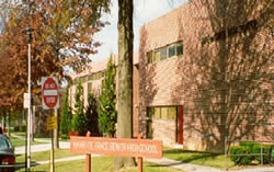
Harford Technical High School (HTHS) is a four-year technical public magnet school high school in Bel Air in Harford County, Maryland, United States. The school, located near the center of the county, is across the street from Harford Community College and next to the Harford Academy.
Baltimore Country Club is a private club in Baltimore, Maryland, with two campuses, one in the city's Roland Park neighborhood and the other in the north suburb of Lutherville. It is one of only twelve clubs nationwide to operate two campuses. The club was founded on January 13, 1898, and hosted the U.S. Open the following year. Its original golf course at the Roland Park campus was the first 18-hole course built in the state of Maryland. The USGA lists Baltimore Country Club as one of the first 100 clubs established in the United States.
The Metropolitan Open is a golf tournament organized by the Metropolitan Golf Association. In the early 20th century it was one of the top events in the country and was retroactively given PGA Tour-level status.
The 1975 Open Championship was the 104th Open Championship, played 9–13 July at Carnoustie Golf Links in Scotland. In his first Open, Tom Watson won an 18-hole playoff by one stroke over Jack Newton to win the first of his eight major titles, which included five Open Championships.
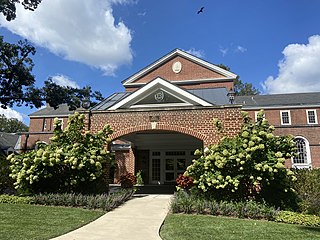
The 1928 PGA Championship was the 11th PGA Championship, held October 1–6 at the Five Farms Course of the Baltimore Country Club in Lutherville, Maryland, north of Baltimore. Then a match play championship, Leo Diegel defeated Al Espinosa 6 and 5 in the finals to win the first of his two consecutive titles.
Hershey Country Club is a country club located in Hershey, Pennsylvania, which was founded in 1930 by Milton S. Hershey.
Saucon Valley Country Club is a country club in Upper Saucon Township in the Lehigh Valley region of eastern Pennsylvania near both Allentown and Bethlehem. Its facilities include three 18-hole golf courses and a six-hole beginners course.

The 1915 U.S. Open was the 21st U.S. Open, held June 17–18 at Baltusrol Golf Club in Springfield, New Jersey, west of New York City. Four-time U.S. Amateur champion Jerome Travers captured his only U.S. Open title, one stroke ahead of runner-up Tom McNamara. The championship was played on the original course at Baltusrol, now known as the Old Course, which no longer exists.
The 1988 U.S. Women's Open was the 43rd U.S. Women's Open, held July 21–24 at the Five Farms East Course of Baltimore Country Club in Lutherville, Maryland, a suburb north of Baltimore.