Carboneras de Guadazaón is a municipality in Cuenca, Castile-La Mancha, Spain. It has a population of 958.

Svinice is a village and municipality in the Trebišov District in the Košice Region of south-eastern Slovakia.
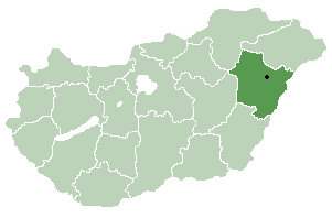
Berekböszörmény is a village in Hajdú-Bihar county, in the Northern Great Plain region of eastern Hungary.
Muñopedro is a municipality located in the province of Segovia, Castile and León, Spain. According to the 2004 census (INE), the municipality has a population of 382 inhabitants.
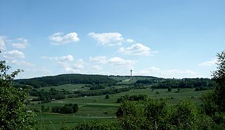
The Knüllgebirge or simply Knüll is a small mountain range in the northern part of Hesse, Germany, approximately 45 kilometres (28 mi) south of Kassel. Its highest peak is the Eisenberg, with an altitude of 635.5 metres (2,085 ft). The area is heavily forested and has a low population density compared to neighbouring regions. The principal town of the region is Schwarzenborn, with a population of 1158 (2006), which is the site of German army Jägerregiment 1 headquarters.

Sărmaș is a commune in Harghita County, Romania. Ethnic Romanians represent the majority. The commune is composed of five villages: Hodoșa (Gyergyóhodos), Fundoaia (Fundoja), Platonești (Kerekfenyő), Runc (Runk) and Sărmaș.

Deleni is a commune in Iași County, Romania. It is composed of six villages: Deleni, Feredeni, Leahu-Nacu, Maxut, Poiana and Slobozia.

Beriyakend is a village in the Saatly Rayon of Azerbaijan.
Deurali, Tanahu is a village development committee in Tanahu District in the Gandaki Zone of central Nepal. At the time of the 1991 Nepal census it had a population of 2910 people living in 44 individual households.
Hasıllı is a village and municipality in the Jalilabad Rayon of Azerbaijan. It has a population of 392.
Məşədivəlli is a village and municipality in the Jalilabad Rayon of Azerbaijan. It has a population of 105.
Çolpı is a village and municipality in the Saatly Rayon of Azerbaijan. The village was raised to municipality status in 2004.
Qusays is a village in eastern Yemen. It is located in the Hadhramaut Governorate.
Varbóc is a village in Borsod-Abaúj-Zemplén County in northeastern Hungary.
Okoliyte is a village in Tryavna Municipality, in Gabrovo Province, in northern central Bulgaria.
Velentsi is a village in Tryavna Municipality, in Gabrovo Province, in northern central Bulgaria.
Körpeli is a village in the District of Dinar, Afyonkarahisar Province, Turkey.

İsmetpaşa is a village in Mahmudiye District of Eskişehir Province, Turkey. At 39°28′N30°53′E it is situated in the high plains of Central Anatolia. Distance to Mahmudiye is 10 kilometres (6.2 mi) and to Eskişehir is 50 kilometres (31 mi). The population of İsmetpaşa was 1356. as of 2012. The original population of the town was composed of migrants from Razgrad of modern Bulgaria in 1920s and the town is named after İsmet İnönü the second president of Turkish Republic who won two decisive battles in Eskişehir Province during the Turkish War of Independence.


