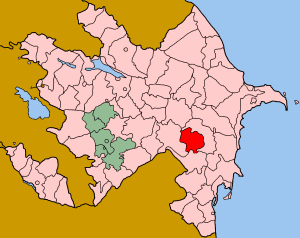
Balakend, Saatly

Last updated

Coordinates: 39°57′N48°27′E / 39.950°N 48.450°E / 39.950; 48.450

Geographic coordinate system Coordinate system

A geographic coordinate system is a coordinate system that enables every location on Earth to be specified by a set of numbers, letters or symbols. The coordinates are often chosen such that one of the numbers represents a vertical position and two or three of the numbers represent a horizontal position; alternatively, a geographic position may be expressed in a combined three-dimensional Cartesian vector. A common choice of coordinates is latitude, longitude and elevation. To specify a location on a plane requires a map projection.

Balakend
Azerbaijan adm location map.svg
Red pog.svg
Balakend
Coordinates: 39°57′N48°27′E / 39.950°N 48.450°E / 39.950; 48.450
CountryFlag of Azerbaijan.svg  Azerbaijan
Rayon Saatly
Time zone AZT (UTC+4)
  Summer (DST) AZT (UTC+5)

Balakend is a village in the Saatly Rayon of Azerbaijan.

Azerbaijan republic in Western Asia and Eastern Europe

Azerbaijan, officially the Republic of Azerbaijan, is a country in the South Caucasus region of Eurasia at the crossroads of Eastern Europe and Western Asia. It is bounded by the Caspian Sea to the east, Russia to the north, Georgia to the northwest, Armenia to the west and Iran to the south. The exclave of Nakhchivan is bounded by Armenia to the north and east, Iran to the south and west, and has an 11 km long border with Turkey in the northwest.


Related Research Articles

Makassar Strait strait between the islands of Borneo and Sulawesi in Indonesia

Makassar Strait is a strait between the islands of Borneo and Sulawesi in Indonesia. To the north it joins the Celebes Sea, while to the south it meets the Java Sea. The Mahakam River of Borneo empties into the strait.

Bilasuvar District Rayon in Azerbaijan

Bilasuvar - is a rayon of Azerbaijan. Bilasuvar city is its administrative center. There are 26 municipalities.

Saatly District district of Azerbaijan

Saatly is an administrative district (rayon) in Azerbaijan. It was established in 1943 and has a current population of 87,000. The district's headquarters are in the city of Saatlı.

Abbasbeyli Place in Saatly, Azerbaijan

Abbasbeyli is a village in the Saatly Rayon of Azerbaijan.

Agamamedli, Saatly Place in Saatly, Azerbaijan

Agamamedli is a village in the Saatly Rayon of Azerbaijan.

Saatlı (city) Place in Saatly, Azerbaijan

Saatlı is a city in and the capital of the Saatly Rayon of Azerbaijan.

Minbashyly Place in Saatly, Azerbaijan

Minbashyly is a village in the Saatly Rayon of Azerbaijan.

Balakend, Gadabay Place in Gadabay, Azerbaijan

Balakend is a village in the Gadabay Rayon of Azerbaijan.

Beriyakend, Saatly Place in Saatly, Azerbaijan

Beriyakend is a village in the Saatly Rayon of Azerbaijan.

Molday Place in Saatly, Azerbaijan

Molday is a village in the Saatly Rayon of Azerbaijan.

Agaragimli Place in Saatly, Azerbaijan

Agaragimli is a village in the Saatly Rayon of Azerbaijan.

Yuxarı Məzrə is a village in the Jabrayil Rayon of Azerbaijan.

Genişkənd is a village and municipality in the Saatly Rayon of Azerbaijan. It has a population of 557.

Hacıqasımlı is a village and municipality in the Saatly Rayon of Azerbaijan. It has a population of 772.

Yeni Novruzlu is a village and municipality in the Saatly Rayon of Azerbaijan. It has a population of 881.

Bəylər is a village and municipality in the Saatly Rayon of Azerbaijan. It has a population of 1,495.

Çolpı is a village and municipality in the Saatly Rayon of Azerbaijan. The village was raised to municipality status in 2004.

Soltanabad is a village and municipality in the Saatly Rayon of Azerbaijan. The village was raised to municipality status in 2004.

Balakənd is a village and municipality in the Sabirabad Rayon of Azerbaijan. It has a population of 694.

References