Gensis (vicus)

Last updated
Gensis on Tabula Peutingeriana TabulaPeutingeriana - Gensis.jpg
Gensis on Tabula Peutingeriana

Gensis was the Roman settlement vicus in Moesia Superior, now central Serbia, on Cer mountain near Lešnica.

Ancient Rome History of Rome from the 8th-century BC to the 5th-century

In historiography, ancient Rome is Roman civilization from the founding of the Italian city of Rome in the 8th century BC to the collapse of the Western Roman Empire in the 5th century AD, encompassing the Roman Kingdom, Roman Republic and Roman Empire until the fall of the western empire. The civilization began as an Italic settlement in the Italian Peninsula, conventionally founded in 753 BC, that grew into the city of Rome and which subsequently gave its name to the empire over which it ruled and to the widespread civilisation the empire developed. The Roman Empire expanded to become one of the largest empires in the ancient world, though still ruled from the city, with an estimated 50 to 90 million inhabitants and covering 5.0 million square kilometres at its height in AD 117.

Vicus kind of populated place in the Roman Empire

In Ancient Rome, the vicus was a neighborhood or settlement. During the Republican era, the four regiones of the city of Rome were subdivided into vici. In the 1st century BC, Augustus reorganized the city for administrative purposes into 14 regions, comprising 265 vici. Each vicus had its own board of officials who oversaw local matters. These administrative divisions are recorded as still in effect at least through the mid-4th century.

Serbia Republic in Southeastern Europe

Serbia, officially the Republic of Serbia, is a country situated at the crossroads of Central and Southeast Europe in the southern Pannonian Plain and the central Balkans. The sovereign state borders Hungary to the north, Romania to the northeast, Bulgaria to the southeast, North Macedonia to the south, Croatia and Bosnia and Herzegovina to the west, and Montenegro to the southwest. The country claims a border with Albania through the disputed territory of Kosovo. Serbia's population is about seven million. Its capital, Belgrade, ranks among the oldest and largest citiеs in southeastern Europe.

Contents

Tabula Peutingeriana

It is recorded in the Tabula Peutingeriana as situated XXX m.p. south of Sirmium, on via Argentaria, a road leading in the direction of Drina; on the mountain Cer area, and XV m.p. from Ad Drinum (allegedly today's Loznica).

<i>Tabula Peutingeriana</i> map of the road network in the Roman Empire

Tabula Peutingeriana, also referred to as Peutinger's Tabula or Peutinger Table, is an illustrated itinerarium showing the layout of the cursus publicus, the road network of the Roman Empire.

Sirmium Roman and Byzantine city

Sirmium was a city in the Roman province of Pannonia. First mentioned in the 4th century BC and originally inhabited by Illyrians and Celts, it was conquered by the Romans in the 1st century BC and subsequently became the capital of the Roman province of Pannonia Inferior. In 294 AD, Sirmium was proclaimed one of four capitals of the Roman Empire. It was also the capital of the Praetorian prefecture of Illyricum and of Pannonia Secunda. Sirmium was located on the Sava river, on the site of modern Sremska Mitrovica in northern Serbia. The site is protected as an Archaeological Site of Exceptional Importance. The modern region of Syrmia (Srem) was named after the city.

The Via Argentaria was a Roman and medieval trade route through the Dinaric Alps. It was named after the Roman silver that was transported between the mint in Salona, the silver mines east of Ilidža and in Srebrenica, and the mint in Sirmium. At the south end, it connected the areas of today's Solin and Split, northeastwards through the Dinaric Alps starting at Klis and Sinj, with central Bosnia, turning northward along the Drina and connecting today's Sremska Mitrovica.

Position

However, the position of Gensis is not established because on the same mountain Cer are located ruins of the three different settlements that can be vicus Gensis, Vidin Grad, Kosanin grad and Trojanov Grad. As none of these three sites has been explored, it is not possible to determine the exact position of vicus Gensis.

Cer (mountain) mountain

Cer is a mountain in western Serbia, 30 kilometers from Šabac, 100 kilometers west of Belgrade. The highest peak has an elevation of 689 m (2,260 ft) above sea level. Cer is rich in the Turkey oak forests after which it was named.

Vidin Grad was a fortress, located at the top of the Vidojevica hill, near village Lešnica, municipality of Loznica,

Trojanov Grad

Trojanov Grad or Town of Trajan was a fortress on mountain Cer, central Serbia, which is being attributed to the mythical Slavic Emperor Trajan.

See also

Koviljkin grad

Koviljkin grad or Koviljka is a name for archaeological ruins close to Banja Koviljača in the Loznica district of western Serbia. The ruins are of a Roman town, which may have been named Gensis; the name has never been confirmed. It is located on the top of a hill, and the remains of the walls spread about 150 metres around it.

Related Research Articles

Mačva District District of Serbia in Šumadija and Western Serbia

The Mačva Districtpronounced [mǎtʃʋanskiː ôkruːɡ]) is one of eight administrative districts of Šumadija and Western Serbia. It expands in the western parts of Serbia, in the geographical regions of Mačva, Podrinje, Posavina, and Pocerina. According to the 2011 census results, it has a population of 298,931 inhabitants. The administrative center of the Mačva district is the city of Šabac.

Berkovitsa Place in Montana, Bulgaria

Berkovitsa is a town and ski resort in northwestern Bulgaria. It is the administrative centre of the homonymous Berkovitsa Municipality, Montana Province and is close to the town of Varshets. As of December 2009, it has a population of 13,917 inhabitants.

Battle of Cer battle fought between Austria-Hungary and Serbia in August 1914

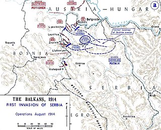
The Battle of Cer was a military campaign fought between Austria-Hungary and Serbia in August 1914 during the early stages of the Serbian Campaign of the First World War. It took place around Cer Mountain and several surrounding villages, as well as the town of Šabac.

Banja Koviljača Place in Serbia

Banja Koviljača is a popular tourist and spa town locateded in the city of Loznica, Serbia. Situated on the west border of Serbia by the Drina river, 137 kilometres (85 mi) from Belgrade, it is the oldest spa town in Serbia. As of 2011 census, it has 7,000 inhabitants.

Gensis may refer to:

Loznica City in Šumadija and Western Serbia, Serbia

Loznica is a city located in the Mačva District of western Serbia. It lies on the right bank of the Drina river. In 2011 the city had a total population of 19,572, while the administrative area had a population of 79,327.

Lešnica, Serbia Village in Serbia

Lešnica is a village in western Serbia. It is located in the municipality of Loznica, in the Mačva District. Lešnica's current population is 4,731.

The Jerez is a river in western Serbia, a 56 km-long right tributary to the Sava river.

The Jadar region begins roughly at the Osečina and it is divided in two sub-regions: Upper Jadar, which is part of much larger region of Rađevina, and Lower Jadar, which is also part of another, larger region of Podrinje. Center of the Lower Jadar is the town of Loznica, which is not on the Jadar river, but some 10 km to the southwest.

Donja Badanja Village in Serbia

Donja Badanja is a village in western Serbia. It is located in the municipality of Loznica, in the Mačva District. Donja Badanja's current population is 510. According to 1991 census population was 670.

Drina river, which forms a large portion of the border between Bosnia and Herzegovina and Serbia

The Drina is a 346 km (215 mi) long international river, which forms a large portion of the border between Bosnia and Herzegovina and Serbia. It is the longest tributary of the Sava River and the longest karst river in the Dinaric Alps which belongs to the Danube river watershed. Its name is derived from the Latin name of the river which in turn is derived from Greek.

Battle of Loznica (1941) battle

The Battle of Loznica involved an attack on the German garrison of that town by the Jadar Chetnik Detachment on 31 August 1941. Following the World War II German-led Axis invasion of Yugoslavia in April 1941, the Kingdom of Yugoslavia was partitioned. At the time, Loznica was part of the German-occupied territory of Serbia, which included Serbia proper, with the addition of the northern part of Kosovo, and the Banat.

Tronoša Monastery monastery

The Tronoša Monastery is a Serbian Orthodox monastery between the villages of Tršić and Korenita, in the administrative town of Loznica, in western Serbia. It is ecclesiastically part of the Eparchy of Šabac. According to tradition, the monastery was built by King Stefan Dragutin.

The Capture of Banja Koviljača was a long battle fought by allied forces of Chetnik Detachments of the Yugoslav Army (Chetniks) with Yugoslav Partisans against German forces. On 1 September 1941, the allies attacked German soldiers who were garrisoned in an outpost at Banja Koviljača. This was the beginning of the hostilities of the April war. The Battle of Koviljača reflected skillful command by leaders of the uprising in Serbia.

Jadar Museum History museum in Loznica, Serbia

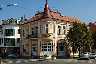
The Jadar Museum is a history museum located in Loznica, Serbia. It has a permanent collection dedicated to man's activities in the area of Podrinje from prehistory until 1950. The museum is housed in the Old Pharmacy Building, which is the cultural monument of great importance.

Memorial Ossuary, Cer

Memorial Ossuary Cer was built in the village Tekeriš on the mountain Cer. The remains of the killed Serbian soldiers after the Battle of Cer in the First World War were buried there. Memorial ossuary Cer is on the list of Cultural Monuments of Exceptional Importance.

References

Aleksandar Deroko was a Serbian architect, artist, and author. He was a professor of the Belgrade University and a member of the Serbian Academy of Sciences and Arts.

Belgrade City in Serbia

Belgrade is the capital and largest city of Serbia. It is located at the confluence of the Sava and Danube rivers and the crossroads of the Pannonian Plain and the Balkans. The urban area of the City of Belgrade has a population of 1.23 million, while nearly 1.7 million people live within its administrative limits.