Geo-fence

Last updated

Two geofences defined in a GPS application GeoFence.jpg
Two geofences defined in a GPS application

A geofence is a virtual perimeter for a real-world geographic area. [1] A geofence can be dynamically generated (as in a radius around a point location) or match a predefined set of boundaries (such as school zones or neighborhood boundaries).

Contents

The use of a geofence is called geofencing, and one example of use involves a location-aware device of a location-based service (LBS) user entering or exiting a geofence. Geofencing approach is based on the observation that users move from one place to another and then stay at that place for a while. This method combines awareness of the user's current location with awareness of the user's proximity to locations that may be of interest. [2] This activity could trigger an alert to the device's user as well as messaging to the geofence operator. This info, which could contain the location of the device, could be sent to a mobile telephone or an email account.

History

Geofencing was invented in the early 1990s and patented in 1995 by American inventor Michael Dimino, using the first-of-its-kind GPS and GSM technology for tracking and locating anywhere on the globe from a remote location.

Cellular geofencing for global tracking is cited in the United States Patent Office over 240 times by major companies such as IBM and Microsoft since 1995 and is first mentioned as: [3]

A global tracking system (GTS) for monitoring an alarm condition associated with and locating a movable object, the GTS comprising:

a cellular telephone located with the movable object;
a GPS (global positioning system) receiver located with the movable object, the GPS receiver being effective for providing data reflecting a present spacial position of the movable object, in terms of spacial latitude/longitude coordinates;
an interface between the GPS receiver and the cellular telephone, the interface being connected between the GPS receiver and the cellular telephone and including circuitry for transmitting the spacial coordinates from the GPS receiver through the telephone, wirelessly to a remote location; and
an alarm for detecting that the object has been moved, by calculating a spatial movement of the object which exceeds a predetermined distance based on information supplied by the GPS receiver, and the alarm initiating the transmission to the remote location the spatial coordinates from the GPS receiver when said movement of predetermined distance has been detected.

Working

Geofencing uses technologies like GPS, or even IP address ranges to build its virtual fence. In most cases, mobile phones are using combinations of positioning methods, e.g. Assisted GPS (A-GPS). “A-GPS uses assistance data received from the network to obtain a faster location calculation compared with GPS alone.” [4] The global system of tracking and geofencing is supported by a group of subsystems based on global navigation satellite system (GNSS) services. Both horizontal and vertical accuracy of GNSS is just a few centimetres for baseline ≤ 5 km. [5] The Wide Area Augmentation System (WAAS) is used by devices equipped and used in North America – the accuracy is considered to be within 3 m at least 95% of the time. [6] These virtual fences can be used to track the physical location of the device active in the particular region or the fence area. The location of the person using the device is taken as geocoding data and can be used further for advertising purposes.

It is possible to monitor several geofences at once (multiple active geofences). The number of active geofences on Android devices is limited to 100 per app and per user. [7] It is possible to monitor different type of triggering activity for each geofence separately – entrance, exit, or dwell in the monitored area.

Types

There are two types of geofencing – it depends on the purpose of the application, which one of them is better to use.

Active

It uses GPS services for the entire time when the application is running and therefore consumes more battery as a result. The reason for the higher battery consumption is the fact that the service requires running in the foreground throughout the time of usage.

Passive

This type does not require a constantly active state of the application and is able to run in the background. It is rather suitable for the process of data collection. It does not use GPS services, therefore cannot be used for an app depending on real time (sending notifications immediately, etc).

Pros and cons

Advantages

Disadvantages

Applications

Policing

The FBI has used geofence warrants to identify rioters who participated in the 6 January Capitol attack. [8]

Safety

Geofencing, used with child location services, can notify parents if a child leaves a designated area. [9]

It is also being used for flexible home controls and monitoring system – for example setting a phone to unlock the door or turn on the heating when arriving home. [10]

Geofencing used with location-based guns can restrict those firearms to fire only in locations where their firing is permitted, thereby making them unable to be used elsewhere.

Other applications include sending an alert if a vehicle is stolen, [11] and notifying rangers when wildlife stray into farmland. [12]

A geofence can be used for location-based messaging for tourist safety and communication. [13]

In 2015, US Senator Charles Schumer proposed a law requiring drone manufacturers to build geofencing constraints into unmanned aerial vehicle navigation systems that would override the commands of the unsophisticated operator, preventing the device from flying into protected airspace. [14] [15]

In the workplace

Geofencing is critical to telematics. It allows users of the system to draw zones around places of work, customer's sites and secure areas. These geofences when crossed by an equipped vehicle or person can trigger a warning to the user or operator via SMS or email.

In some companies, geofencing is used by the human resource department to monitor employees working in special locations, especially those doing field works. Using a geofencing tool, an employee is allowed to log his or her attendance using a GPS-enabled device when within a designated perimeter.

Geofencing, in a security strategy model, provides security to wireless local area networks. This is done by using predefined borders (e.g., an office space with borders established by positioning technology attached to a specially programmed server). The office space becomes an authorized location for designated users and wireless mobile devices. [16] [ page needed ]

Satellite

During the use of Starlink satellites in the Russo-Ukrainian War, SpaceX used geofencing to limit the use of Starlink Internet services outside the borders of Ukraine such as in Russian-occupied territories in Ukraine. [17]

Applications of geofencing extend to advertising & geomarketing. Geofencing solution providers allow marketers and advertisers to precisely choose the exact location that their ads show up on. Geofencing uses different types of targeting to identify zip codes, street addresses, GPS coordinates using latitude and longitude, as well as IP targeting.

Geofencing enables competitive marketing tactics for advertisers and marketers to grab the attention of in-market shoppers in their competitive store location, large scale events such as concerts, sports events, conferences, etc. in stadiums, convention centers, malls, outlets, parks, neighborhoods. For example: at a concert, a digital ad relating to the performer or an affiliated company could be sent to only those people in the venue.

For example, a local auto-dealership builds a virtual boundary within a few square miles from its dealership's location to target car buyers within the same neighborhood. This way they limit their ad spending on prospects who are more likely to purchase in order to get a better ROI. Using tracking technologies to identify devices where the ads were shown, geofencing solution providers are able to provide walk-in attribution for their advertising. This means that using a geofencing solution, companies can now track the customers who walked into the showroom after seeing the ad. This level of attribution provides better visibility and analytics for marketers to spend their advertising budget wisely.

A local service business may only be interested in (a) likely clients (b) within a service region or catchment basin. Broadcasting or advertising more extensively brings irrelevant responses and wastes energy, time, money, and opportunity. Electronic advertising can identify and target only desired market objects (people).

Business

Target Corporation settled for $5 million with the San Diego City Attorney in April 2022, promising to audit and improve pricing procedures, after a San Diego complaint that the company used geofencing to raise prices when a customer entered a store. [18]

See also

Related Research Articles

<span class="mw-page-title-main">Global Positioning System</span> American satellite-based radio navigation service

The Global Positioning System (GPS), originally Navstar GPS, is a satellite-based radio navigation system owned by the United States government and operated by the United States Space Force. It is one of the global navigation satellite systems (GNSS) that provide geolocation and time information to a GPS receiver anywhere on or near the Earth where there is an unobstructed line of sight to four or more GPS satellites. It does not require the user to transmit any data, and operates independently of any telephonic or Internet reception, though these technologies can enhance the usefulness of the GPS positioning information. It provides critical positioning capabilities to military, civil, and commercial users around the world. Although the United States government created, controls and maintains the GPS system, it is freely accessible to anyone with a GPS receiver.

<span class="mw-page-title-main">Galileo (satellite navigation)</span> Global navigation satellite system

Galileo is a global navigation satellite system (GNSS) that went live in 2016, created by the European Union through the European Space Agency (ESA), operated by the European Union Agency for the Space Programme (EUSPA), headquartered in Prague, Czechia, with two ground operations centres in Fucino, Italy, and Oberpfaffenhofen, Germany. The €10 billion project is named after the Italian astronomer Galileo Galilei.

Location-based service (LBS) is a general term denoting software services which use geographic data and information to provide services or information to users. LBS can be used in a variety of contexts, such as health, indoor object search, entertainment, work, personal life, etc. Commonly used examples of location-based services include navigation software, social networking services, location-based advertising, and tracking systems. LBS can also include mobile commerce when taking the form of coupons or advertising directed at customers based on their current location. LBS also includes personalized weather services and even location-based games.

Automatic vehicle location is a means for automatically determining and transmitting the geographic location of a vehicle. This vehicle location data, from one or more vehicles, may then be collected by a vehicle tracking system to manage an overview of vehicle travel. As of 2017, GPS technology has reached the point of having the transmitting device be smaller than the size of a human thumb, able to run 6 months or more between battery charges, easy to communicate with smartphones — all for less than $20 USD.

In the context of information security, and especially network security, a spoofing attack is a situation in which a person or program successfully identifies as another by falsifying data, to gain an illegitimate advantage.

<span class="mw-page-title-main">Telematics</span> Interdisciplinary field that encompasses telecommunications

Telematics is an interdisciplinary field encompassing telecommunications, vehicular technologies, electrical engineering, and computer science. Telematics can involve any of the following:

<span class="mw-page-title-main">Assisted GNSS</span> System to improve the time-to-first-fix of a GNSS receiver

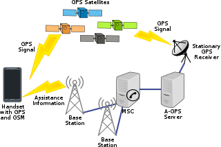
Assisted GNSS (A-GNSS) is a GNSS augmentation system that often significantly improves the startup performance—i.e., time-to-first-fix (TTFF)—of a global navigation satellite system (GNSS). A-GNSS works by providing the necessary data to the device via a radio network instead of the slow satellite link, essentially "warming up" the receiver for a fix. When applied to GPS, it is known as assisted GPS or augmented GPS. Other local names include A-GANSS for Galileo and A-Beidou for BeiDou.

<span class="mw-page-title-main">Satellite navigation</span> Use of satellite signals for geo-spatial positioning

A satellite navigation or satnav system is a system that uses satellites to provide autonomous geopositioning. A satellite navigation system with global coverage is termed global navigation satellite system (GNSS). As of 2023, four global systems are operational: the United States's Global Positioning System (GPS), Russia's Global Navigation Satellite System (GLONASS), China's BeiDou Navigation Satellite System, and the European Space Agency's Galileo.

<span class="mw-page-title-main">Mobile phone tracking</span> Identifying the location of a mobile phone

Mobile phone tracking is a process for identifying the location of a mobile phone, whether stationary or moving. Localization may be affected by a number of technologies, such as the multilateration of radio signals between (several) cell towers of the network and the phone or by simply using GNSS. To locate a mobile phone using multilateration of mobile radio signals, the phone must emit at least the idle signal to contact nearby antenna towers and does not require an active call. The Global System for Mobile Communications (GSM) is based on the phone's signal strength to nearby antenna masts.

<span class="mw-page-title-main">Differential GPS</span> Enhancement to the Global Positioning System providing improved accuracy

Differential Global Positioning Systems (DGPSs) supplement and enhance the positional data available from global navigation satellite systems (GNSSs). A DGPS for GPS can increase accuracy by about a thousandfold, from approximately 15 metres (49 ft) to 1–3 centimetres.

<span class="mw-page-title-main">Local-area augmentation system</span> All-weather aircraft landing system

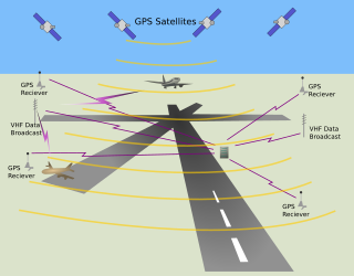
The local-area augmentation system (LAAS) is an all-weather aircraft landing system based on real-time differential correction of the GPS signal. Local reference receivers located around the airport send data to a central location at the airport. This data is used to formulate a correction message, which is then transmitted to users via a VHF Data Link. A receiver on an aircraft uses this information to correct GPS signals, which then provides a standard instrument landing system (ILS)-style display to use while flying a precision approach. The FAA has stopped using the term LAAS and has transitioned to the International Civil Aviation Organization (ICAO) terminology of ground-based augmentation system (GBAS). While the FAA has indefinitely delayed plans for federal GBAS acquisition, the system can be purchased by airports and installed as a Non-Federal navigation aid.

A GPS tracking unit, geotracking unit, satellite tracking unit, or simply tracker is a navigation device normally on a vehicle, asset, person or animal that uses satellite navigation to determine its movement and determine its WGS84 UTM geographic position (geotracking) to determine its location. Satellite tracking devices may send special satellite signals that are processed by a receiver.

A positioning system is a system for determining the position of an object in space. One of the most well-known and commonly used positioning systems is the Global Positioning System (GPS).

Augmentation of a global navigation satellite system (GNSS) is a method of improving the navigation system's attributes, such as precision, reliability, and availability, through the integration of external information into the calculation process. There are many such systems in place, and they are generally named or described based on how the GNSS sensor receives the external information. Some systems transmit additional information about sources of error, others provide direct measurements of how much the signal was off in the past, while a third group provides additional vehicle information to be integrated in the calculation process.

Global Navigation Satellite System (GNSS) receivers, using the GPS, GLONASS, Galileo or BeiDou system, are used in many applications. The first systems were developed in the 20th century, mainly to help military personnel find their way, but location awareness soon found many civilian applications.

<span class="mw-page-title-main">Indoor positioning system</span> Network of devices used to wirelessly locate objects inside a building

An indoor positioning system (IPS) is a network of devices used to locate people or objects where GPS and other satellite technologies lack precision or fail entirely, such as inside multistory buildings, airports, alleys, parking garages, and underground locations.

<span class="mw-page-title-main">Satellite navigation device</span> Device that can calculate its geographical position based on satellite information

A satellite navigation device, satnav device or satellite navigation receiver is a user equipment that uses one or more of several global navigation satellite systems (GNSS) to calculate the device's geographical position and provide navigational advice. Depending on the software used, the satnav device may display the position on a map, as geographic coordinates, or may offer routing directions.

The Celestron SkyScout was a model of handheld consumer electronic instrument for astronomical orientation and education, similarly to the competitor product mySky by Meade Instruments. The general class of zero-magnification sky-orientation scopes using modern geodesy was made possible by the commercialisation of GPS and other GNSS systems in the early 21st century, and the SkyScout was an early example of such use despite being hampered by technical and price limitations.

A vehicle tracking system combines the use of automatic vehicle location in individual vehicles with software that collects these fleet data for a comprehensive picture of vehicle locations. Modern vehicle tracking systems commonly use GPS or GLONASS technology for locating the vehicle, but other types of automatic vehicle location technology can also be used. Vehicle information can be viewed on electronic maps via the Internet or specialized software. Urban public transit authorities are an increasingly common user of vehicle tracking systems, particularly in large cities.

Locata Corporation is a privately held technology company headquartered in Canberra, Australia, with a fully owned subsidiary in Las Vegas, Nevada. Locata has invented a local positioning system that can either replace or augment Global Positioning System (GPS) signals when they are blocked, jammed or unreliable. Government, commercial and other organizations use Locata to determine accurate positioning as a local backup to GPS.

References

  1. Rouse, Margaret (December 2016). "What is geo-fencing (geofencing)?". WhatIs.com. Newton, Massachusetts: TechTarget. Retrieved 26 January 2020.
  2. Namiot, Dmitry; Sneps-Sneppe, Manfred (2013). "Geofence and Network Proximity". In Balandin, Sergey; Andreev, Sergey; Koucheryavy, Yevgeni (eds.). Internet of Things, Smart Spaces, and Next Generation Networking. Lecture Notes in Computer Science. Vol. 8121. Berlin, Heidelberg: Springer. pp. 117–127. arXiv: 1303.5943 . doi:10.1007/978-3-642-40316-3_11. ISBN   978-3-642-40316-3. S2CID   15873599.
  3. "Telephone operable global tracking system for vehicles". United States Patent Office. December 1995.
  4. Namiot, Dmitry (2 December 2022). "GeoFence services | Namiot | International Journal of Open Information Technologies". International Journal of Open Information Technologies. 1 (9): 30–33. Retrieved 2 December 2022.
  5. Khomsin, Ira Mutiara Anjasmara, Danar Guruh Pratomo, and Wahyu Ristanto (2019). "Accuracy Analysis of GNSS (GPS, GLONASS and BEIDOU) Obsevation[sic] for Positioning" (PDF). E3S Web of Conferences. 94: 01019. Bibcode:2019E3SWC..9401019K. doi:10.1051/e3sconf/20199401019. S2CID   165073579 via The Authors.{{cite journal}}: CS1 maint: multiple names: authors list (link)
  6. United States. Federal Aviation Administration, ed. (31 October 2008). "Global Positioning System wide area augmentation system (WAAS) performance standard".{{cite journal}}: Cite journal requires |journal= (help)
  7. "Create and monitor geofences". Android Developers. Retrieved 2 December 2022.
  8. Harris, Mark (30 September 2021). "How a Secret Google Geofence Warrant Helped Catch the Capitol Riot Mob". Wired. Retrieved 10 November 2021.
  9. De Lara, Eyal; Anthony LaMarca; Mahadev Satyanarayanan (2008). Location Systems: An Introduction to the Technology Behind Location Awareness . Synthesis Lectures on Mobile and Pervasive Computing, Lecture #4. Morgan & Claypool Publishers. p. 88. ISBN   978-1-59829-581-8 via Google Books.
  10. Amudha, S.; Sankar, S. Sasi Rekha; Rajkumar, Mishra Neel; Jain, Aayush (21 June 2019). "Enhancement of smart home automation system using secure geofence concept in IoT". AIP Conference Proceedings. 2112 (1): 020036. Bibcode:2019AIPC.2112b0036A. doi: 10.1063/1.5112221 . ISSN   0094-243X. S2CID   198339104.
  11. "Motorcycle Tracker Updates Every 15 Seconds". Motorcycle USA. 23 January 2009. Archived from the original on 31 January 2009. Retrieved 26 January 2009. Courtesy True Tracker Pro
  12. "Kenya's elephants send text messages to rangers". CBS News. Associated Press. 11 October 2008. Retrieved 26 January 2020.
  13. "Location Based Messaging for Tourist Safety and Communication" (PDF). UgoRound Australia Pty Ltd. July 2017. Archived from the original (PDF) on 26 September 2017. Retrieved 26 January 2020.
  14. "Todd Humphreys: Don't Overregulate Drones". Alcalde. 18 March 2015. Retrieved 5 April 2015.
  15. Schumer, Charles (19 August 2015). "Schumer proposes law" . Retrieved 15 December 2015.
  16. Hamid Jahankhani, A G Hessami, Feng Hsu: Global security, safety, and sustainability : 5th international conference, ICGS3 2009, London, UK, 1–2 September 2009 : proceedings. ISBN   978-3-642-04061-0
  17. Kim, Victoria (8 September 2023). "Elon Musk Acknowledges Withholding Satellite Service to Thwart Ukrainian Attack". The New York Times. ISSN   0362-4331 . Retrieved 10 September 2023.
  18. Norfleet, Nicole (29 April 2022). "Target pays $5 million in settlement over pricing accuracy allegations". Star Tribune. Retrieved 29 April 2022.

Further reading