Related Research Articles

Warragul is a town in Victoria, Australia, 102 kilometres south-east of Melbourne. Warragul lies between the Strzelecki Ranges to the south and the Mount Baw Baw Plateau of the Great Dividing Range to the north. As of the 2021 census, the town had a population of 19,856 people. Warragul forms part of a larger urban area that includes nearby Drouin that had an estimated total population of 42,827 as of the 2021 census.

The Latrobe Valley is an inland geographical district and urban area of the Gippsland region in the state of Victoria, Australia. The traditional owners are the Brayakaulung of the Gunai nation. The district lies east of Melbourne and nestled between the Strzelecki Ranges to the south and the Baw Baw Ranges, part of the Great Dividing Range, to the north. Mount St Phillack is the highest peak to the north of the Latrobe Valley, due north of Moe. The highest peak to the south is Mt Tassie, south of Traralgon.

The Shire of Baw Baw is a local government area in Victoria, Australia, in the eastern part of the state. It covers an area of 4,028 square kilometres (1,555 sq mi) and in 2021 had a population of 57,626.
Noojee is a town in the Gippsland region of Victoria, Australia, north of Warragul and east of Melbourne, in the Baw Baw local government area. At the 2016 census, Noojee and the surrounding area had a population of 157. The town benefits from tourists passing through to the Mount Baw Baw Alpine Resort, 48 kilometres away, as it is the last stop with tourism services. There are also a number of walks in the area, including the Noojee Trestle Bridge, a 100m wooden rail bridge.

Mount Baw Baw is a mountain summit on the Baw-Baw Plateau of the Great Dividing Range, located in Gippsland, Victoria, Australia. The name is from the Yarra-Yallou, Gunna-Kurnai people of Gippsland. It is of uncertain meaning, but possibly signifies, echo, or ghost.

Drouin is a town in the West Gippsland region, 90 kilometres (56 mi) east of Melbourne, in the Australian state of Victoria. Its local government area is the Shire of Baw Baw, and is home to the shire council's headquarters despite being the second-largest town in the shire, behind neighbouring Warragul. The town's name is believed to be derived from an Aboriginal word meaning "north wind". New housing developments have accelerated the town's residential growth in recent years. As at the 2016 census, Drouin had a population of 11,887 people.

Moe is a town in the Latrobe Valley in the Gippsland region of Victoria, Australia. It is approximately 130 kilometres east of the central business district of Melbourne, 45 kilometres due south of the peak of Mount Baw Baw in the Great Dividing Range and features views of the Baw Baw Ranges to the north and Strzelecki Ranges to the south.

Yarragon is a town in the Shire of Baw Baw in the West Gippsland region of Victoria, Australia. The town lies on the Princes Highway and the Gippsland railway line approximately halfway between the major towns of Warragul and Moe. Hills of the Strzelecki Ranges rise over 500 metres (1,600 ft) immediately to the south of the town, providing a spectacular backdrop, while the Moe River and the lowlands lie to the north and east. Mount Worth at 515 m (1,690 ft) above sea level is the highest near peak to the south in the Mount Worth State Park 16 kilometres (9.9 mi) SSW of Yarragon. Mount Baw Baw at 1,563 m (5,128 ft) in the Baw Baw Ranges as part of the Great Dividing Range to the north is approximately 85 kilometres (53 mi) NNE of Yarragon. The township sits at approximately 88 metres (289 ft) above sea level. At the 2006 census, Yarragon had a population of 1131.

The Division of McMillan was an Australian Electoral Division in the state of Victoria. It was located in the western part of the Gippsland region, which extends for the length of Victoria's eastern Bass Strait coastline. It included the outer south-eastern Melbourne suburb of Pakenham, and also included the towns of Warragul, Moe, Wonthaggi, Leongatha and Foster. It stretched from Mount Baw Baw and the Baw Baw National Park in the north to Wilsons Promontory, and the Wilsons Promontory National Park in the south. It was the southernmost electoral division in continental Australia. It was replaced by the Division of Monash in 2019.

Neerim South is a town in West Gippsland, Victoria, Australia, located in the Shire of Baw Baw, 110 kilometres (68 mi) east of Melbourne and 20 kilometres (12 mi) north of Warragul. At the 2021 census, Neerim South had a population of 1,599.
Darnum is a town in West Gippsland, Victoria, Australia, located 110 km east of Melbourne and a short distance to Warragul, in the Shire of Baw Baw. It is nestled between the Great Dividing Range and Strzelecki Ranges. The Moe River meanders through the edge of the township which the historic Darnum Butter Factory overlooks.
West Gippsland is a region of Gippsland in Victoria, Australia. It covers an area of 19,639 square kilometres (7,583 sq mi) that extends from San Remo in the west to Lakes Entrance in the east, up to Mount Howitt in the north.
The Ellinbank and District Football Netball League (EDFNL), formerly known as the Ellinbank & District Football League (EDFL), is an Australian rules football and netball league, based in the West Gippsland region of Victoria for smaller towns and villages in the regions of Baw Baw, South Gippsland and Cardinia.
The Shire of Buln Buln was a local government area about 95 kilometres (59 mi) east-southeast of Melbourne, the state capital of Victoria, Australia. The shire covered an area of 1,259 square kilometres (486.1 sq mi), and existed from 1878 until 1994.

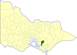
The Rural City of Warragul was a local government area about 100 kilometres (62 mi) east-southeast of Melbourne, the state capital of Victoria, Australia. The rural city covered an area of 352.2 square kilometres (136.0 sq mi), and existed from 1881 until 1994.
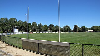
Western Park is a recreation reserve on the western side of the West Gippsland town of Warragul, Victoria.
The Noojee railway line is a closed railway line in Victoria, Australia. Branching off from the Gippsland line at Warragul station, it was built to service the timber industry in the upper Latrobe River area, transporting timber as well as providing a general goods and passenger service to townships in the area. The final section of the line between Neerim South and Noojee traversed increasingly hilly terrain and featured a number of large timber trestle bridges. Extensively and repeatedly damaged by bushfires over the years, the line was closed in the 1950s and dismantled. The last remaining large trestle bridge on the line has been preserved and has become a popular local tourist attraction.
The Moe River is a perennial river of the West Gippsland catchment, located in the West Gippsland region of the Australian state of Victoria.

The Division of Monash is an Australian Electoral Division in the state of Victoria, which was contested for the first time at the 2019 federal election.

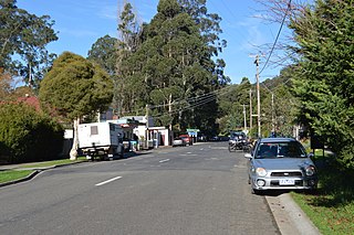
Neerim Junction is a town in West Gippsland, Victoria, Australia, located in the Shire of Baw Baw, 89 kilometres (55 mi) from Melbourne and 26 kilometres (16 mi) from Warragul. At the 2016 Census, Neerim Junction had a population of 127. Its postcode is 3832 and its Main Street hosts a general store with an Australia Post office, a small playground and a petrol station. It is one of several Neerim settlements, the others being Neerim South, Neerim North, Neerim and Neerim East.
References
- ↑ "Saluting a brave dad doomed to die young". 18 October 2018.
- ↑ "About". Archived from the original on 24 October 2009.