This article needs additional citations for verification .(October 2018) |
Geology of Mumbai refers to the geology of the city of the island city of Mumbai.
Back Bay and Bandra reclamation are the major reclamation areas of Mumbai in the Arabian sea.
This article needs additional citations for verification .(October 2018) |
Geology of Mumbai refers to the geology of the city of the island city of Mumbai.
Back Bay and Bandra reclamation are the major reclamation areas of Mumbai in the Arabian sea.
The predominant soil cover in Mumbai city is sandy, whereas in the suburban district, the soil cover is alluvial and loamy.
| Land Usage | Mumbai city district (area in km2. and %) | Mumbai suburban district (area in km2. and %) |
|---|---|---|
| Inhabited area | 53.84, 79.45% | 277.5, 75% |
| Agricultural area | Nil | 18.5, 5% |
| Industrial area | 13.5, 19.9% | 41.0, 11.69% |
| Forest Cover | 0.4543, 0.7% | 33.0, 8.31% |
| Wastelands | Nil | Nil |
| Total: | 67.79 km2 | 370 square kilometres |
| Source:Relief and rehabitation (Mumbai) [1] | ||

Mumbai is the capital city of the Indian state of Maharashtra. According to the United Nations, as of 2018, Mumbai is the second-most populous city in the country after Delhi and the seventh-most populous city in the world with a population of roughly 20 million. As per the Indian government population census of 2011, Mumbai was the most populous city in India with an estimated city proper population of 12.5 million living under Municipal Corporation of Greater Mumbai. Mumbai is the centre of the Mumbai Metropolitan Region, the sixth most populous metropolitan area in the world with a population of over 23 million. Mumbai lies on the Konkan coast on the west coast of India and has a deep natural harbour. In 2008, Mumbai was named an alpha world city. It has the highest number of millionaires and billionaires among all cities in India. Mumbai is home to three UNESCO World Heritage Sites: the Elephanta Caves, Chhatrapati Shivaji Maharaj Terminus, and the city's distinctive ensemble of Victorian and Art Deco buildings.

Soil salinity is the salt content in the soil; the process of increasing the salt content is known as salinization. Salts occur naturally within soils and water. Salination can be caused by natural processes such as mineral weathering or by the gradual withdrawal of an ocean. It can also come about through artificial processes such as irrigation and road salt.

The Kowloon Peninsula is a peninsula that forms the southern part of the main landmass in the territory of Hong Kong, alongside Victoria Harbour and facing toward Hong Kong island. The Kowloon Peninsula and the area of New Kowloon are collectively known as Kowloon.

Land rehabilitation as a part of environmental remediation is the process of returning the land in a given area to some degree of its former state, after some process has resulted in its damage. Many projects and developments will result in the land becoming degraded, for example mining, farming and forestry.

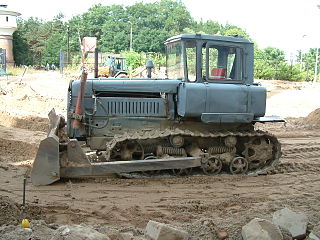
Mining in the engineering discipline is the extraction of minerals from underneath, above or on the ground. Mining engineering is associated with many other disciplines, such as mineral processing, exploration, excavation, geology, and metallurgy, geotechnical engineering and surveying. A mining engineer may manage any phase of mining operations, from exploration and discovery of the mineral resources, through feasibility study, mine design, development of plans, production and operations to mine closure.
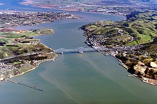
The Carquinez Strait is a narrow tidal strait in Northern California. It is part of the tidal estuary of the Sacramento and the San Joaquin rivers as they drain into the San Francisco Bay. The strait is eight miles (13 km) long and connects Suisun Bay, which receives the waters of the combined rivers, with San Pablo Bay, a northern extension of the San Francisco Bay.

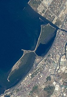
Land reclamation, usually known as reclamation, and also known as land fill, is the process of creating new land from oceans, seas, riverbeds or lake beds. The land reclaimed is known as reclamation ground or land fill.

Nariman Point is a business district in Downtown Mumbai. Formerly the prominent business district on India's west coast, Nariman Point yielded that status to Mumbai's Bandra-Kurla Complex in 2010. Prior to Nariman Point's development, Mumbai's business centre was at Ballard Estate, which – like Nariman Point also – was built on land reclaimed from the sea.

In mining, overburden is the material that lies above an area that lends itself to economical exploitation, such as the rock, soil, and ecosystem that lies above a coal seam or ore body. Overburden is distinct from tailings, the material that remains after economically valuable components have been extracted from the generally finely milled ore. Overburden is removed during surface mining, but is typically not contaminated with toxic components. Overburden may also be used to restore an exhausted mining site during reclamation.
Engineering geology is the application of geology to engineering study for the purpose of assuring that the geological factors regarding the location, design, construction, operation and maintenance of engineering works are recognized and accounted for. Engineering geologists provide geological and geotechnical recommendations, analysis, and design associated with human development and various types of structures. The realm of the engineering geologist is essentially in the area of earth-structure interactions, or investigation of how the earth or earth processes impact human made structures and human activities.

The Seven Islands of Bombay were 16th-century Portuguese colonial possessions lying off the Konkan, the mid-west coast of India, that were partly handed over to England under this title as part of the dowry of Catherine Braganza when she married Charles II in 1661. The isles and islets had earlier been part of indigenous polities like the Silhara dynasty and the Gujarat Sultanate before they were captured by the Portuguese in 1534. After acquiring them as through a royal dowry from the Kingdom of Portugal, Charles II leased Bombay and adjacent islets to the East India Company in 1668 for £10 per year.

Salsette Island is an island in Konkan division of the state of Maharashtra on India's west coast. Administratively known as the Bombay Suburban district, the suburbs of Mumbai (Bombay) and a portion of Thane and Mira-Bhayander lie on it, making it very populous and one of the most densely populated islands in the world. It has a population approaching 20 million inhabitants living on an area of about 619 square kilometres (239 sq mi).

Mine reclamation is the process of restoring land that has been mined to a natural or economically usable state. Although the process of mine reclamation occurs once mining is completed, the planning of mine reclamation activities occurs prior to a mine being permitted or started. Mine reclamation creates useful landscapes that meet a variety of goals ranging from the restoration of productive ecosystems to the creation of industrial and municipal resources. In the United States, mine reclamation is a regular part of modern mining practices. Modern mine reclamation reduces the environmental effects of mining.
Land development is altering the landscape in any number of ways such as:
The Western Freeway was a proposed controlled-access highway in Mumbai, India that would stretch from Marine Drive in South Mumbai to Kandivli in the north, a distance of 29 km. The project envisioned the construction of four major sea links over the Arabian Sea along Mumbai's western coastline to reduce traffic-congestion between the Western Suburbs and South Mumbai.

Back Bay is a waterbody off the coast of Mumbai city, located to its (south) west and joins the Arabian Sea.

The word Maharashtra, the land of the Marathi-speaking people, appears to be derived from Maharashtrian, an old form of Prakrit. Some consider it was a inspired of the term 'Maha Kantara', a synonym for 'Dandakaranya'. Maharashtra is the third largest state in India after Rajasthan and Madhya Pradesh. It covers an area of 307,713 km2 and is bordered by the states of Madhya Pradesh to the north, Chhattisgarh to the east, Telangana to the southeast, Karnataka to the south and Goa to the southwest. The state of Gujarat lies to the northwest, with the Union territory of Dadra and Nagar Haveli sandwiched between the borders. Maharashtra has coastline of 720 km.The Arabian Sea makes up Maharashtra's west coast. Maharashtra consists of two major relief divisions. The plateau is a part of the Deccan tableland and the Konkan coastal strip abutting on the Arabian Sea.

Twitchell Island is an island in the Sacramento-San Joaquin River Delta in Sacramento County, California, 35 kilometres southwest of Sacramento. At 2 metres below sea level, the 1,200 ha (3,000-acre) is bounded on the north by Seven Mile Slough, on the east and south by the San Joaquin River, and on the west by Three Mile Slough. The island is entirely within the Rio Vista Gas Field, although well pads and associated infrastructure make up only a small part of its land use. It is managed by Reclamation District 1601.
The Las Piñas–Parañaque Critical Habitat and Ecotourism Area (LPPCHEA), also known as the Las Piñas–Parañaque Wetland Park, is a protected area at the coasts of the cities of Las Piñas and Parañaque in Metro Manila, Philippines. The entire wetland is a declared Ramsar site under the Ramsar Convention of UNESCO.
The Coastal Road is an under construction 8-lane, 22.2-km long freeway that would run along Mumbai's western coastline connecting Marine Lines in the south to Kandivali in the north. The Coastal Road is projected to be used by 130,000 vehicles daily and is expected to reduce travel time between South Mumbai and the Western Suburbs from 2 hours to 40 minutes. The estimated cost of the project is ₹12,000 crore (US$1.7 billion). Its first phase, a 9.98 km section from Princess Street flyover to the Worli end of the Bandra-Worli Sea Link, is expected to be completed by November 2023.
| | This article about a regional geological feature is a stub. You can help Wikipedia by expanding it. |