Related Research Articles

Sir Sandford Fleming was a Scottish Canadian engineer and inventor. Born and raised in Scotland, he emigrated to colonial Canada at the age of 18. He promoted worldwide standard time zones, a prime meridian, and use of the 24-hour clock as key elements to communicating the accurate time, all of which influenced the creation of Coordinated Universal Time. He designed Canada's first postage stamp, produced a great deal of work in the fields of land surveying and map making, engineered much of the Intercolonial Railway and the first several hundred kilometers of the Canadian Pacific Railway, and was a founding member of the Royal Society of Canada and founder of the Canadian Institute.

Pender Island is one of the Southern Gulf Islands located in the Gulf of Georgia, British Columbia, Canada. Pender Island is approximately 34 km2 (13 sq mi) in area and is home to about 2,250 permanent residents, as well as a large seasonal population. Like most of the rest of the Southern Gulf Islands, Pender Island enjoys a sub-Mediterranean climate and features open farmland, rolling forested hills, several lakes and small mountains, as well as many coves and beaches.

Bathurst Island is one of the Queen Elizabeth Islands in Nunavut, Canada. It is a member of the Arctic Archipelago. The area of the island is estimated at 16,042 km2 (6,194 sq mi), 115 to 117 mi long and from 63 mi (101 km) to 72 mi (116 km) to 92.9 mi (149.5 km) wide, making it the 54th largest island in the world and Canada's 13th largest island. It is uninhabited.
Bowden is a town in central Alberta, Canada. It is located in Red Deer County on the Queen Elizabeth II Highway, approximately 45 km (28 mi) south of Red Deer.

Jervis Inlet is one of the principal inlets of the British Columbia Coast, about 95 km (59 mi) northwest of Vancouver, and the third of such inlets north of the 49th parallel, the first of which is Burrard Inlet, Vancouver's harbour.

Dodge Cove is a small unincorporated community of fewer than 100 people, located on Digby Island, British Columbia, Canada across from the city of Prince Rupert. In April 2015, the community had an estimated total of 29 residents. Dodge Cove does not have paved roads, automobiles or shopping centres, and was named in 1907 after George Blanchard Dodge. It was built over a Tsimshian village named Kanagatsiyot. A commercial ferry service has been proposed to service the area and other nearby communities. In contemporary times, construction of a liquefied natural gas facility was proposed, which some of the community's residents oppose.

Indian Arm is a steep-sided glacial fjord adjacent to the city of Vancouver in southwestern British Columbia. Formed during the last Ice Age, it extends due north from Burrard Inlet, between the communities of Belcarra and the District of North Vancouver, then on into mountainous wilderness. Burrard Inlet and the opening of Indian Arm was mapped by Captain George Vancouver and fully explored days later by Dionisio Alcalá Galiano in June 1792.

Arthur Oliver Wheeler was born in Ireland and immigrated to Canada in 1876 at the age of 16. He became a land surveyor and surveyed large areas of western Canada, including photo-topographical surveys of the Selkirk Mountains and the British Columbia-Alberta boundary along the continental divide through the Canadian Rockies. In 1906, he and journalist Elizabeth Parker were the principal founders of the Alpine Club of Canada (ACC). He was its first president, from 1906 to 1910, and editor of the Canadian Alpine Journal from 1907 to 1930. He remained Honorary President of the ACC from 1926 until his death in 1945. The Arthur O. Wheeler hut of the ACC is named after him.

Valdes Island is one of the Gulf Islands located in the Strait of Georgia, British Columbia, Canada. It is across Porlier Pass from Galiano Island, which lies to the southeast. It has an area of 23 square kilometres, and is 1.6 kilometres wide by 16 kilometres in length. The island is popular with kayakers, boaters and has historically been the site of several human settlements.
Sir Edward Oliver Wheeler MC was a Canadian surveyor, mountain climber and soldier. Wheeler participated in the first topographical survey of Mount Everest in 1921. As a brigadier in the British Army he was appointed Surveyor General of India in 1941. He was knighted for the work he did surveying India. He was an accomplished mountain climber and on the 1921 expedition was one of the team to reach the 7000-metre North Col.
Smith Sound is a zigzag 24 kilometre inner region of Trinity Bay. This sound is one of the longest portions of inshore waterways in Newfoundland, located on its north-eastern coast in the Canadian province of Newfoundland and Labrador. Bonavista Peninsula is to the north of the sound, while Random Island is to the south. The waters that make up the sound is a continuous channel that encircles Random Island, broken only by a narrow channel located at Clarenville where a causeway was built to provide access to the communities on Random Island. The channel on the south side of Random Island is North West Arm.
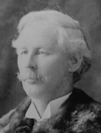
Édouard-Gaston Daniel Deville, was the first to perfect a practical method of photogrammetry, the making of maps based on photography. He was the Surveyor General of Canada (1885–1924) and Canada's Director General for the Bureau of Surveys (1922–24). During his lifetime, Canadian surveyors had used his phototopography to map 83,678 square kilometres, roughly the size of Ireland.
Jarvis Pass is a mountain pass in Kakwa Provincial Park in the Northern Rockies of British Columbia, Canada, located to the north of Kakwa Lake, on the British Columbia-Alberta boundary, and therefore is on the Continental Divide. It was one of the many passes surveyed as a route for the Canadian Pacific Railway in the 1870s.
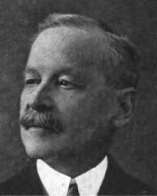
Colonel William Patrick Anderson (1851–1927) was a Canadian civil engineer. He was Superintendent of Lighthouses for almost 40 years, and was responsible for many of the more notable lighthouses in Canada.
Deville Glacier is a glacier flowing along the south side of the Laussedat Heights into Andvord Bay, on the west coast of Graham Land. The glacier is shown on an Argentine government chart of 1952. It was named by the UK Antarctic Place-Names Committee in 1960 for Edouard G. Deville, Surveyor-General of Canada, 1885–1924, who introduced and developed photogrammetric methods of survey in Canada from 1888 onward.

The Illecillewaet Glacier is a glacier in British Columbia, Canada. It is located inside Glacier National Park in the Selkirk Mountains, a sub-range of the Columbia Mountains. After the construction of the Canadian Pacific Railway (CPR) near the glacier’s terminus, and the building of a hotel nearby, the glacier became a prominent tourist destination in the Canadian west. Easily accessible by road and railway, it is one of the most-studied glaciers in North America. Its retreat over the last one hundred years has been extensively documented.
The Association of British Columbia Land Surveyors (ABCLS) is a self-governing, non-profit, non-governmental organization which sets educational requirements, examines for admission, and regulates professional land surveyors within British Columbia, Canada. The ABCLS is responsible for developing bylaws and guidelines for the conduct of its members, establishing and administering entry requirements for the profession, and liaising with governmental bodies and other associations to improve the quality of the profession's service to the public.
James Joseph McArthur was a Canadian surveyor and mountaineer who was the first to climb several peaks in the Canadian Rocky Mountains. Two mountains and a lake are named after him, and he gave names to various other features. He was a pioneer in the use of photography for surveying, under the direction of the Surveyor General, Édouard-Gaston Deville. He did extensive work on surveying the borders between Canada and the United States in the Yukon and west of Lake Superior.
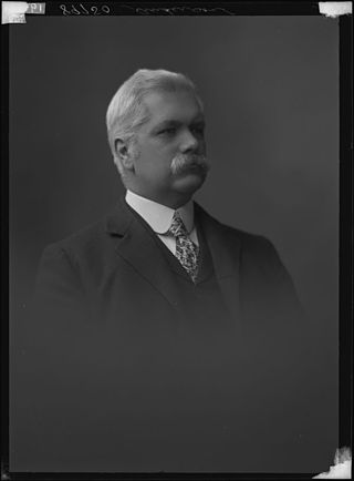
William Pearce (1848–1930), was a surveyor, statistician, planner, and administrator in western Canada. He served in the federal government from 1874 to 1904 as federal surveyor and administrator, as federal advisor for western development and as Western consultant for the Canadian Pacific Railway Company. As Inspector of Dominion Lands Agencies, he oversaw the "development and allocation of all land, forests, mineral and water resources" from "Winnipeg to the eastern foothills of the Rockies"—representing 400,000 square miles of land, earning his nickname—"Czar of the West". He was known for his work on the Bow River watershed irrigation systems that transformed lands in southern Alberta into fertile land.

Mount Wheeler, is a 3,336-metre (10,945-foot) mountain summit located in Glacier National Park of British Columbia, Canada. It is the third-highest peak in the park, and sixth-highest in the Selkirk Mountains range. The mountain is a remote 60 km (37 mi) east of Revelstoke, and 40 km (25 mi) southwest of Golden. Its nearest higher peak is Mount Selwyn, 5.1 km (3.2 mi) to the north-northwest. Mount Wheeler is surrounded by ice, including the Deville Glacier, Deville Névé, Black Glacier, and Thor Glacier. Precipitation runoff from the mountain and meltwater from its glaciers drains into tributaries of the Incomappleux and Beaver Rivers.
References
- ↑ "Dodge, George Blanchard, 1874-1945". BC Archives. Royal BC Museum . Retrieved 3 March 2016.
- 1 2 Thomson, Don W. (1967). Men and Meridians: The History of Surveying and Mapping in Canada, Volume 2. Queen's Printer.
- ↑ Cheryl K. Ypma (2008). "Dodge Cove History 101". Dodge Cove Arts Guild. Archived from the original on 10 July 2011. Retrieved 20 June 2010.
| | This article about a Canadian engineer, inventor or industrial designer is a stub. You can help Wikipedia by expanding it. |