Related Research Articles

Kincardineshire, also known as the Mearns, is a historic county, registration county and lieutenancy area on the coast of northeast Scotland. It is bounded by Aberdeenshire on the north and west, and by Angus on the south.

Ury House is a large ruined mansion in Aberdeenshire, Scotland, built in the Elizabethan style in 1885 by Sir Alexander Baird, 1st Baronet. It is situated on the north-east coast about 1 mile (1.6 km) north of Stonehaven in the former county of Kincardineshire.
Red Moss is a wetland bog in Aberdeenshire, Scotland, located at the northwestern edge of the village of Netherley. The moss is designated a national Site of Special Scientific Interest by Scottish Natural Heritage, due to its biodiversity and undisturbed character. The elevation of Red Moss is 113 metres above mean sea level. The upland areas above Red Moss are characterised as agricultural and woodland parcels which are generally attractive and separated by ancient drystone walls or hedgerows.

Bridge of Muchalls is an entirely residential hamlet in Aberdeenshire, Scotland by the North Sea. It is on the A90 dual carriageway about three miles north of Stonehaven and to the south of Muchalls Castle.
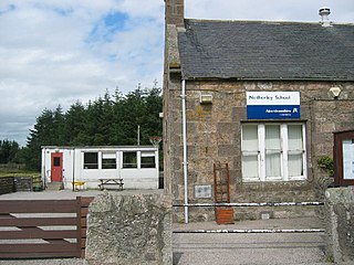
Netherley, Scotland is a village in Aberdeenshire, situated approximately five miles northwest of Stonehaven. Netherley is located in the Mounth area of the Grampian Highlands. At the eastern edge of Netherley is a significant wetland bog known as Red Moss. To the southwest of Netherley lie Meikle Carewe Hill and Curlethney Hill. At the south edge of Netherley is the peak of Craggie Cat.
The Burn of Muchalls is an easterly flowing stream in Aberdeenshire, Scotland that discharges to the North Sea. Its point of discharge is on a rocky beach set with scenic sea stacks. Flowing principally over agricultural lands, the Burn of Muchalls traverses through the hamlet of the Bridge of Muchalls, flows beneath the A90 road and thence to the rugged shoreline of the North Sea slightly to the south of Doonie Point. Just above the discharge to the North Sea is a scenic pool, used in the drowning scene of Ophelia in the Franco Zeffirelli film Hamlet. A northern fork of the Burn of Muchalls flows over lands of Muchalls Castle prior to the confluence with the mainstem Burn of Muchalls within the Bridge of Muchalls.
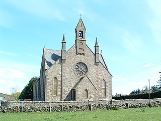
Cookney is a hamlet in Aberdeenshire, Scotland in proximity to Netherley in the Mounth of the Grampian Highlands. The community is situated on a hilltop approximately 5 miles (8 km) northwest of Stonehaven, about 3 miles (5 km) northwest of the Bridge of Muchalls, and about 2 miles (3 km) west of Muchalls Castle. From Cookney a portion of the ancient route of the Causey Mounth is visible to the east near Whinward Farm, although the track is not truly recognizable from that distance. The Cookney Church is a prominent historic landmark of Cookney.

Banchory-Devenick is a village approximately two kilometres south of the city of Aberdeen, Scotland in the Lower Deeside area of Aberdeenshire. The village should not be confused with the historic civil parish of the same name which spanned the River Dee until 1891, its northern part lying in Aberdeenshire and its southern part in Kincardineshire. In that year the northern part became part of the neighbouring parish of Peterculter, the southern part remaining as the parish of Banchory-Devenick. The village of Banchory-Devenick is on the B9077 road, and the ancient Causey Mounth passes directly through the village. An historic graveyard dating to 1157 AD is present at the village of Banchory-Devenick. Other historic features in the vicinity include Saint Ternan's Church, Muchalls Castle and the Lairhillock Inn.

Cowton Burn is a stream that rises in the Mounth, or eastern range of the Grampian Mountains, on some of the northwest slopes of the Durris Forest west of Netherley, Aberdeenshire, Scotland. The Grid Reference for the headwaters is NO 925 823); Cowton Burn is a tributary to the Cowie Water. The Cowton Burn is crossed by the A957 road slightly northwest of Rickarton House.

Saint Ternan's Church is an Episcopal church in the Diocese of Brechin, near Muchalls in Aberdeenshire, Scotland.
Craggie Cat is a hill landform in the Mounth of the Grampian Mountains at the southern edge of Netherley, Aberdeenshire, Scotland. The peak elevation of Craggie Cat is 198 metres according to the Ordnance Survey. This hill's southwestern flanks form the northwest boundary of the moorland of Curlethney Hill.

Durris Forest is a chiefly coniferous forest south of the River Dee approximately three kilometres west of Netherley in Aberdeenshire, Scotland. The A957 road forms the southwest boundary of Durris Forest, separating it from Fetteresso Forest. The Durris Forest includes several smaller named woodlands. The ancient route of Elsick Mounth crosses the Grampian Mounth within the Durris Forest. Notable natural features in the vicinity include Red Moss and Meikle Carewe Hill. Notable historic features in this area include Raedykes Roman Camp, Muchalls Castle and Maryculter House.
Cookney Parish Church, now business premises within a converted listed building, was a Christian place of worship in the village of Cookney, Aberdeenshire, Scotland.
Alexander Fraser of Touchfraser and Cowie was a member of the Scottish nobility who served as the Lord Chamberlain of Scotland and also as the Sheriff of Stirling and Sheriff of Kincardine. He was a descendant of the Clan Fraser members deriving from Oliver Castle. Alexander died at the Battle of Dupplin Moor.

The Elsick Mounth is an ancient trackway crossing the Grampian Mountains in the vicinity of Netherley, Scotland. This trackway was one of the few means of traversing the Grampian Mounth area in prehistoric and medieval times. The highest pass of the route is attained within the Durris Forest. Notable historical structures in the vicinity are Maryculter House, Lairhillock Inn and Muchalls Castle. Most of the lands through which the Elsick Mounth passes are within the Durris Forest; while this forest would have been a mixed deciduous forest in ancient times, currently it is managed as a coniferous monoculture with extensive amounts of clearfelling and subsequent replanting.
The Barony of Cowie is a geographical and political division of land in Aberdeenshire, Scotland deriving from the Middle Ages. King Robert the Bruce conferred these lands of the Barony of Cowie, along with the Barony of Cluny and the Barony of Kinnaird upon Alexander Fraser of Touchfraser and Cowie, who was his Chamberlain at least as late as 1319 AD. The major transport route across the Barony of Cowie in the Middle Ages was an ancient trackway known as the Elsick Mounth,

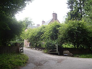
Netherley House is a mansion built by Alexander Silver in the late 18th century in Netherley, Aberdeenshire, Scotland. It is situated near the northerly flowing drainage of Crynoch Burn. The home was sold to Horatio Ross by James Silver, son of George Silver in 1853 for 33,000 pounds sterling.. It subsequently came into the possession of the descendants of General Nathaniel Forbes of Auchernach, who held it until 1901.
William Rickart Hepburn was a Scottish politician and soldier who lived in Kincardineshire and was responsible for the construction of Rickarton House.
Alexander Silver was a wealthy East India Company trader, who lived in Netherley, Aberdeenshire, Scotland in the late 18th century; he and his son George Silver were noted agricultural innovators of their era. Alexander
Mergie is a settlement in Aberdeenshire approximately six miles west of Stonehaven, Scotland. Situated in the former Kincardineshire slightly south of the Slug Road.
References
- ↑ George Robertson, A general view of Kincardineshire or the Mearns (1810)
- ↑ Douglas Gordon Barron, The Court Book of the Barony of Urie in Kincardineshire: 1604-1747, published 1892
- ↑ C. Michael Hogan, History of Muchalls Castle, Lumina Tech Press, (2005)
| | This Scottish biographical article is a stub. You can help Wikipedia by expanding it. |
| | This article related to Aberdeenshire, Scotland, is a stub. You can help Wikipedia by expanding it. |