Related Research Articles

Methane clathrate (CH4·5.75H2O) or (8CH4·46H2O), also called methane hydrate, hydromethane, methane ice, fire ice, natural gas hydrate, or gas hydrate, is a solid clathrate compound (more specifically, a clathrate hydrate) in which a large amount of methane is trapped within a crystal structure of water, forming a solid similar to ice. Originally thought to occur only in the outer regions of the Solar System, where temperatures are low and water ice is common, significant deposits of methane clathrate have been found under sediments on the ocean floors of the Earth. Methane hydrate is formed when hydrogen-bonded water and methane gas come into contact at high pressures and low temperatures in oceans.

Clathrate hydrates, or gas hydrates, clathrates, hydrates, etc., are crystalline water-based solids physically resembling ice, in which small non-polar molecules or polar molecules with large hydrophobic moieties are trapped inside "cages" of hydrogen bonded, frozen water molecules. In other words, clathrate hydrates are clathrate compounds in which the host molecule is water and the guest molecule is typically a gas or liquid. Without the support of the trapped molecules, the lattice structure of hydrate clathrates would collapse into conventional ice crystal structure or liquid water. Most low molecular weight gases, including O2, H2, N2, CO2, CH4, H2S, Ar, Kr, and Xe, as well as some higher hydrocarbons and freons, will form hydrates at suitable temperatures and pressures. Clathrate hydrates are not officially chemical compounds, as the enclathrated guest molecules are never bonded to the lattice. The formation and decomposition of clathrate hydrates are first order phase transitions, not chemical reactions. Their detailed formation and decomposition mechanisms on a molecular level are still not well understood. Clathrate hydrates were first documented in 1810 by Sir Humphry Davy who found that water was a primary component of what was earlier thought to be solidified chlorine.

The Paleocene–Eocene Thermal Maximum (PETM), alternatively "Eocene thermal maximum 1" (ETM1), and formerly known as the "Initial Eocene" or "Late Paleocene Thermal Maximum", was a time period with a more than 5–8 °C global average temperature rise across the event. This climate event occurred at the time boundary of the Paleocene and Eocene geological epochs. The exact age and duration of the event is uncertain but it is estimated to have occurred around 55.5 million years ago.

A cold seep is an area of the ocean floor where hydrogen sulfide, methane and other hydrocarbon-rich fluid seepage occurs, often in the form of a brine pool. Cold does not mean that the temperature of the seepage is lower than that of the surrounding sea water. On the contrary, its temperature is often slightly higher. The "cold" is relative to the very warm conditions of a hydrothermal vent. Cold seeps constitute a biome supporting several endemic species.

A mud volcano or mud dome is a landform created by the eruption of mud or slurries, water and gases. Several geological processes may cause the formation of mud volcanoes. Mud volcanoes are not true igneous volcanoes as they do not produce lava and are not necessarily driven by magmatic activity. Mud volcanoes may range in size from merely 1 or 2 meters high and 1 or 2 meters wide, to 700 meters high and 10 kilometers wide. Smaller mud exudations are sometimes referred to as mud-pots.

In geotechnical engineering, drilling fluid, also called drilling mud, is used to aid the drilling of boreholes into the earth. Often used while drilling oil and natural gas wells and on exploration drilling rigs, drilling fluids are also used for much simpler boreholes, such as water wells. One of the functions of drilling mud is to carry cuttings out of the hole.
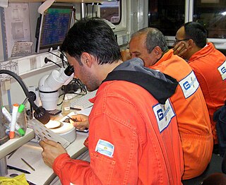
The National Institute of Ocean Technology (NIOT) was established in November 1993 as an autonomous society under the Ministry of Earth Sciences, Government of India. NIOT is managed by a Governing Council and the Director is the head of the Institute. The institute is based in Chennai.
Mud logging is the creation of a detailed record of a borehole by examining the cuttings of rock brought to the surface by the circulating drilling medium. Mud logging is usually performed by a third-party mud logging company. This provides well owners and producers with information about the lithology and fluid content of the borehole while drilling. Historically it is the earliest type of well log. Under some circumstances compressed air is employed as a circulating fluid, rather than mud. Although most commonly used in petroleum exploration, mud logging is also sometimes used when drilling water wells and in other mineral exploration, where drilling fluid is the circulating medium used to lift cuttings out of the hole. In hydrocarbon exploration, hydrocarbon surface gas detectors record the level of natural gas brought up in the mud. A mobile laboratory is situated by the mud logging company near the drilling rig or on deck of an offshore drilling rig, or on a drill ship.

The clathrate gun hypothesis is a proposed explanation for the periods of rapid warming during the Quaternary. The idea is that changes in fluxes in upper intermediate waters in the ocean caused temperature fluctuations that alternately accumulated and occasionally released methane clathrate on upper continental slopes, these events would have caused the Bond Cycles and individual interstadial events, such as the Dansgaard–Oeschger interstadials.
Carbon dioxide hydrate or carbon dioxide clathrate is a snow-like crystalline substance composed of water ice and carbon dioxide. It normally is a Type I gas clathrate. There has also been some experimental evidence for the development of a metastable Type II phase at A temperature near the ice melting point. The clathrate can exist below 283K (10 °C) at a range of pressures of carbon dioxide. CO2 hydrates are widely studied around the world due to its promising prospects of carbon dioxide capture from flue gas and fuel gas streams relevant to post-combustion and pre-combustion capture. It is also quite likely to be important on Mars due to the presence of carbon dioxide and ice at low temperatures.
The Orca Basin is a mid-slope, silled, mini-basin in the northern Gulf of Mexico some 300 km southwest of the Mississippi River mouth on the Louisiana continental slope. It is unique amongst the mini-basins in this area, in containing a large brine pool of anoxic salt brine. The pool is approximately 123 km2 (47 sq mi) in area and up to 220 m (720 ft) deep under 2,400 m (7,900 ft) depth of Gulf water and is derived from dissolution of underlying Jurassic age Louann Salt. With a volume of 13.3 km3 (3.2 cu mi) the pool results from the dissolution of about 3.62 billion tonnes of the Louann Salt bed into seawater. The basin owes its shape to ongoing salt tectonics and is surrounded by salt diapirs.

The Nankai Trough is a submarine trough located south of the Nankaidō region of Japan's island of Honshū, extending approximately 900 km (559 mi) offshore. The underlying fault, the Nankai megathrust, is the source of the devastating Nankai megathrust earthquakes, while the trough itself is potentially a major source of hydrocarbon fuel, in the form of methane clathrate.

Submarine landslides are marine landslides that transport sediment across the continental shelf and into the deep ocean. A submarine landslide is initiated when the downwards driving stress exceeds the resisting stress of the seafloor slope material, causing movements along one or more concave to planar rupture surfaces. Submarine landslides take place in a variety of different settings, including planes as low as 1°, and can cause significant damage to both life and property. Recent advances have been made in understanding the nature and processes of submarine landslides through the use of sidescan sonar and other seafloor mapping technology.
Oilfield terminology refers to the jargon used by those working in fields within and related to the upstream segment of the petroleum industry. It includes words and phrases describing professions, equipment, and procedures specific to the industry. It may also include slang terms used by oilfield workers to describe the same.
Mount Elbert Methane Hydrate Site
Nankai Methane Hydrate Site is located in the Nankai Trough, Japan.
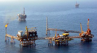
Offshore geotechnical engineering is a sub-field of geotechnical engineering. It is concerned with foundation design, construction, maintenance and decommissioning for human-made structures in the sea. Oil platforms, artificial islands and submarine pipelines are examples of such structures. The seabed has to be able to withstand the weight of these structures and the applied loads. Geohazards must also be taken into account. The need for offshore developments stems from a gradual depletion of hydrocarbon reserves onshore or near the coastlines, as new fields are being developed at greater distances offshore and in deeper water, with a corresponding adaptation of the offshore site investigations. Today, there are more than 7,000 offshore platforms operating at a water depth up to and exceeding 2000 m. A typical field development extends over tens of square kilometers, and may comprise several fixed structures, infield flowlines with an export pipeline either to the shoreline or connected to a regional trunkline.
Ocean Networks Canada is a University of Victoria initiative that operates the NEPTUNE and VENUS cabled ocean observatories in the northeast Pacific Ocean and the Salish Sea. Additionally, Ocean Networks Canada operates smaller community-based observatories offshore from Cambridge Bay, Nunavut., Campbell River, Kitamaat Village and Digby Island. These observatories collect data on physical, chemical, biological, and geological aspects of the ocean over long time periods. As with other ocean observatories such as ESONET, Ocean Observatories Initiative, MACHO and DONET, scientific instruments connected to Ocean Networks Canada are operated remotely and provide continuous streams of freely available data to researchers and the public. Over 200 gigabytes of data are collected every day.
Gas hydrate stability zone, abbreviated GHSZ, also referred to as methane hydrate stability zone (MHSZ) or hydrate stability zone (HSZ), refers to a zone and depth of the marine environment at which methane clathrates naturally exist in the Earth's crust.
References
- ↑ Wunsch, C.; D. E. Gunn (2003). "A densely sampled core and climate variable aliasing". Geo-Marine Letters. 23 (1): 64–71. Bibcode:2003GML....23...64W. doi:10.1007/s00367-003-0125-2. S2CID 12475897.
- ↑ Bloemendal, J.; X. M. Liu; T. C. Rolph (1995). "Correlation of the magnetic susceptibility stratigraphy of Chinese loess and the marine oxygen isotope record: chronological and palaeoclimatic implications". Earth and Planetary Science Letters. 131 (3–4): 371–380. Bibcode:1995E&PSL.131..371B. doi:10.1016/0012-821X(95)00016-6.
- ↑ Robinson, Simon G.; Mark A. Maslin; I. Nicholas McCave (1995). "Magnetic susceptibility variations in Upper Pleistocene deep-sea sediments of the NE Atlantic: Implications for ice rafting and paleocirculation at the Last Glacial Maximum". Paleoceanography. 10 (2): 221–250. Bibcode:1995PalOc..10..221R. doi:10.1029/94PA02683.
- ↑ Offshore-SEA
- ↑ Schultheiss, Peter J.; Timothy J. G. Francis; Melanie Holland; John A. Roberts; H. Amann; Thjunjoto; R. John Parkes; Derek Martin; Martin Rothfuss; Floris Tyunder; Peter D. Jackson (2006). "Pressure coring, logging and subsampling with the HYACINTH system". New Techniques in sediment core analysis. Special Publication. Vol. 267. London: Geological Society. pp. 151–163.
- ↑ Holland, Melanie; Peter J. Schultheiss; John A. Roberts; Matthew J. Druce (2008). "Observed gas hydrate morphologies in marine sediments". Proceedings of the 6th International Conference on Gas Hydrates. 6th International Conference on Gas Hydrates. Vancouver, British Columbia. hdl:2429/1201.
- ↑ Schultheiss, Peter J.; Melanie E. Holland; Gary D. Humphrey (2008). Borehole pressure coring and laboratory pressure core analysis for gas hydrate investigations. Offshore Technology Conference. Houston.
- ↑ Schultheiss, Peter J.; Melanie Holland; John A. Roberts; Gary D. Humphrey (2008). "Pressure core analysis: The keystone of a gas hydrate investigation". Proceedings of the 6th International Conference on Gas Hydrates. 6th International Conference on Gas Hydrates. Vancouver, British Columbia. hdl:2429/1200.
- ↑ "Archived copy". Archived from the original on 2016-11-16. Retrieved 2012-08-25.
{{cite web}}: CS1 maint: archived copy as title (link) - ↑ Weaver, P. P. E.; Peter J. Schultheiss (1990). "Current methods for obtaining, logging and splitting marine sediment cores". In Ernest A. Hailwood; Robert B. Kidd (eds.). Marine geological surveying and sampling. Dordrecht: Kluwer. pp. 85–101. ISBN 978-0-7923-0788-4.