Related Research Articles
In cryptography, a substitution cipher is a method of encrypting in which units of plaintext are replaced with the ciphertext, in a defined manner, with the help of a key; the "units" may be single letters, pairs of letters, triplets of letters, mixtures of the above, and so forth. The receiver deciphers the text by performing the inverse substitution process to extract the original message.

The Vigenère cipher is a method of encrypting alphabetic text by using a series of interwoven Caesar ciphers, based on the letters of a keyword. It employs a form of polyalphabetic substitution.

A projected coordinate system, also known as a projected coordinate reference system, a planar coordinate system, or grid reference system, is a type of spatial reference system that represents locations on the Earth using cartesian coordinates (x,y) on a planar surface created by a particular map projection. Each projected coordinate system, such as "Universal Transverse Mercator WGS 84 Zone 26N," is defined by a choice of map projection (with specific parameters), a choice of geodetic datum to bind the coordinate system to real locations on the earth, an origin point, and a choice of unit of measure. Hundreds of projected coordinate systems have been specified for various purposes in various regions.
The Maidenhead Locator System is a geocode system used by amateur radio operators to succinctly describe their geographic coordinates, which replaced the deprecated QRA locator, which was limited to European contacts. Its purpose is to be concise, accurate, and robust in the face of interference and other adverse transmission conditions. The Maidenhead Locator System can describe locations anywhere in the world.
A geocode is a code that represents a geographic entity. It is a unique identifier of the entity, to distinguish it from others in a finite set of geographic entities. In general the geocode is a human-readable and short identifier.
In cryptography, the ADFGVX cipher was a manually applied field cipher used by the Imperial German Army during World War I. It was used to transmit messages secretly using wireless telegraphy. ADFGVX was in fact an extension of an earlier cipher called ADFGX which was first used on 1 March 1918 on the German Western Front. ADFGVX was applied from 1 June 1918 on both the Western Front and Eastern Front.

The Aztec Code is a matrix code invented by Andrew Longacre, Jr. and Robert Hussey in 1995. The code was published by AIM, Inc. in 1997. Although the Aztec Code was patented, that patent was officially made public domain. The Aztec Code is also published as ISO/IEC 24778:2008 standard. Named after the resemblance of the central finder pattern to an Aztec pyramid, Aztec Code has the potential to use less space than other matrix barcodes because it does not require a surrounding blank "quiet zone".
Cryptanalysis of the Enigma ciphering system enabled the western Allies in World War II to read substantial amounts of Morse-coded radio communications of the Axis powers that had been enciphered using Enigma machines. This yielded military intelligence which, along with that from other decrypted Axis radio and teleprinter transmissions, was given the codename Ultra.
The Irish grid reference system is a system of geographic grid references used for paper mapping in Ireland. The Irish grid partially overlaps the British grid, and uses a similar co-ordinate system but with a meridian more suited to its westerly location.

The pigpen cipher is a geometric simple substitution cipher, which exchanges letters for symbols which are fragments of a grid. The example key shows one way the letters can be assigned to the grid.
Location arithmetic is the additive (non-positional) binary numeral systems, which John Napier explored as a computation technique in his treatise Rabdology (1617), both symbolically and on a chessboard-like grid.
The Military Grid Reference System (MGRS) is the geocoordinate standard used by NATO militaries for locating points on Earth. The MGRS is derived from the Universal Transverse Mercator (UTM) grid system and the Universal Polar Stereographic (UPS) grid system, but uses a different labeling convention. The MGRS is used as geocode for the entire Earth.
Banburismus was a cryptanalytic process developed by Alan Turing at Bletchley Park in Britain during the Second World War. It was used by Bletchley Park's Hut 8 to help break German Kriegsmarine (naval) messages enciphered on Enigma machines. The process used sequential conditional probability to infer information about the likely settings of the Enigma machine. It gave rise to Turing's invention of the ban as a measure of the weight of evidence in favour of a hypothesis. This concept was later applied in Turingery and all the other methods used for breaking the Lorenz cipher.
The B-Dienst, also called xB-Dienst, X-B-Dienst and χB-Dienst, was a Department of the German Naval Intelligence Service of the OKM, that dealt with the interception and recording, decoding and analysis of the enemy, in particular British radio communications before and during World War II. B-Dienst worked on cryptanalysis and deciphering (decrypting) of enemy and neutral states' message traffic and security control of Kriegsmarine key processes and machinery.
The World Geographic Reference System (GEOREF) is a geocode, a grid-based method of specifying locations on the surface of the Earth. GEOREF is essentially based on the geographic system of latitude and longitude, but using a simpler and more flexible notation. GEOREF was used primarily in aeronautical charts for air navigation, particularly in military or inter-service applications, but it is rarely seen today. However, GEOREF can be used with any map or chart that has latitude and longitude printed on it.
The United States National Grid (USNG) is a multi-purpose location system of grid references used in the United States. It provides a nationally consistent "language of location", optimized for local applications, in a compact, user friendly format. It is similar in design to the national grid reference systems used in other countries. The USNG was adopted as a national standard by the Federal Geographic Data Committee (FGDC) of the US Government in 2001.
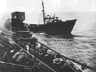
Lauenburg was a German weather ship used in the early years of the Second World War to provide weather reports for German shipping, particularly German U-boats. After the German use of such vessels had been identified as a weakness that could be exploited to break the Enigma code, Lauenburg was captured and sunk on 28 June 1941. The Royal Navy acquired important German code books and parts of an Enigma machine.

BATCO, short for Battle Code, is a hand-held, paper-based encryption system used at a low, front line level in the British Army. It was introduced along with the Clansman combat net radio in the early 1980s and was largely obsolete by 2010 due to the wide deployment of the secure Bowman radios. BATCO consists of a code, contained on a set of vocabulary cards, and cipher sheets for superencryption of the numeric code words. The cipher sheets, which are typically changed daily, also include an authentication table and a radio call sign protection system.
The Cassini Grid was a grid coordinate system used on British military maps during the first half of the twentieth century, particularly during World War II. The referencing consists of square grids drawn on a Cassini projection. For a period after the war, the maps were also used by the general public. The system has been superseded by the Ordnance Survey National Grid.
The Open Location Code (OLC) is a geocode based in a system of regular grids for identifying an area anywhere on the Earth. It was developed at Google's Zürich engineering office, and released late October 2014. Location codes created by the OLC system are referred to as "plus codes".
References
- ↑ Helgason, Guðmundur (1995-01-01). "The War in Maps - The Grid system". Encyclopedia of Things. uboat.net. Retrieved 2016-05-03.