Gestel is a borough in the southwestern part of the city of Eindhoven, Netherlands. Gestel used to be a separate village, and until 1920 was part of the separate municipality of Gestel en Blaarthem.
On 1 January 2005 it had a population of nearly 27,000 people. Gestel consists of three neighbourhoods: Rozenknopje (with Hagekamp, Oude Spoorbaan and Schrijversbuurt), Oud Gestel (with Rapelenburg, Bennekel, Blaarthem, Genderdal, Gennep and de Beemden) and Oud Kasteel (with Genderbeemd, Ooievaarsnest and Hanevoet). Gestel borders other parts of Eindhoven (Strijp, Stratum and Eindhoven Centrum, which is the pre-1920 municipality of Eindhoven, with minor adjustments) and the municipalities of Waalre and Veldhoven.
Eindhoven is a city and municipality of the Netherlands, located in the southern province of North Brabant of which it is its largest and is also located in the Dutch part of the natural region the Campine. With a population of 246,443 on a territory of 88.92 km², it is the fifth-largest city of the Netherlands and the largest outside the Randstad conurbation.
The Spui is a small tidal river in South Holland in the Netherlands, connecting the river Oude Maas and the Haringvliet estuary, separating the islands of Voorne-Putten and Hoeksche Waard. Historically, it forked off the Oude Maas at the town of Oud-Beijerland to end in the Haringvliet, but as a (planned) result from the Delta Works, its flow has been reversed. The Spui emerged as a result of a levee breach during the All Saints' Flood of 1532, a storm surge that permanently altered the surrounding landscape.
Drunen is a town in the municipality of Heusden in the southern Netherlands. The town is part of a region called the Langstraat which is historically known for its leather and shoe industry. Since 1813, Drunen had been a separate municipality, consisting of the towns Drunen, Elshout, and Giersbergen. As of 2017 Drunen's population reached 18,216.
The Hoekse Waard is an island between the Oude Maas, Dordtsche Kil, Hollands Diep, Haringvliet and Spui rivers in the province of South Holland in the Netherlands. The island, part of the namesake municipality of Hoeksche Waard, is a mostly agricultural region, south of the outskirts of Rotterdam. The Hoeksche Waard consists of reclaimed land (polders): after the Saint Elisabeth flood of 1421 most of the area was flooded. The land has been reclaimed gradually in the following centuries.
Tongelre is a borough of Eindhoven. It used to be a separate village to the east of Eindhoven. Waterways comprise most of its borders. It is bordered to the south by a canal, the "Eindhovensch Kanaal" to the borough of Stratum and Geldrop municipality. In the northwest the border with Woensel borough is formed by the river "Dommel" and to the east by the river "Kleine Dommel" towards Nuenen municipality.
Woensel is a former town in the Dutch province of North Brabant, but nowadays a borough of Eindhoven.
Bommenede or Bommenee is a former island, village, and municipality in the Netherlands, located about 5 km east of the city of Brouwershaven.
Gestel en Blaarthem is a former municipality of the Netherlands. The municipality was made up of the villages of Gestel and Blaarthem. On 1 Januari 1920 the municipality merged with the municipality of Eindhoven, together with the former municipalities of Stratum, Strijp, Tongelre and Woensel.
Gestel may refer to several places:
Petrus "Piet" Godefridus de Brouwer was an archer from the Netherlands. He was born in Gestel, North Brabant and died in Eindhoven, North Brabant.
Riethoven is a village in the Dutch province of North Brabant. It is located in the municipality of Bergeijk, about 15 km (9.3 mi) southwest of Eindhoven. The adjacent township of Walik is in general considered to be a part of Riethoven. Riethoven was originally called Rijthoven, but with time it changed into Riethoven. In Dutch The name means: farms at the Rijt, the Rijt being a river near the municipality.
Stratum is a former village in the Dutch province of North Brabant, now one of the seven boroughs of Eindhoven.
Strijp is a former town in the Dutch province of North Brabant, now a borough of Eindhoven.
Baharestan is a locality east of the central part of Tehran in Iran. The historical Baharestan building is located in this neighborhood.
The Municipality of Shoal Lake is a former rural municipality (RM) in the Canadian province of Manitoba. It was originally incorporated as a rural municipality on January 1, 2011. It ceased on January 1, 2015, as a result of its provincially mandated amalgamation with the RM of Strathclair to form the Rural Municipality of Yellowhead.
Rameyen Castle is a castle on a lake in Gestel, part of the municipality of Berlaar, in the province of Antwerp, Belgium. It was once owned by Nicolaas Rubens, Lord of Rameyen, who died in the castle. Nicolaas was the second son of Peter Paul Rubens.
Ooievaarsnest is a neighborhood in Eindhoven, Netherlands. The neighborhood is located in the quarter of Oud Kasteel and district of Gestel, in the extreme southwest of the city and adjoins the southwestern city limits. It is separated from Veldhoven only by the A2 motorway.
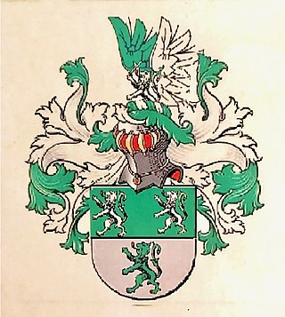
Van Gestel is a Dutch toponymic surname or family name originating from North Brabant. The first use of the name stems from the 11th and 12th century, with the first recorded coat of arms dating to 1308. It is derived from the word "Gestel" and translates to "from Gestel". "Gestel" or "Ghestele" was a name for a higher area between two river valleys, and is a common name or suffix for settlements in the Southern Netherlands. Gestel can refer to several geographical locations:
Sint-Michielsgestel is a village in the municipality of Sint-Michielsgestel, Netherlands.
This page is based on this Wikipedia article Text is available under the CC BY-SA 4.0 license; additional terms may apply. Images, videos and audio are available under their respective licenses.