The Geyser Valley trail in Olympic National Park is an area along the Elwha River between Rica Canyon and the Grand Canyon of the Elwha, where many homesteaders tried to eke out a living in the late 19th and early 20th centuries. Today, this trail allows hikers to visit several interesting sites, as well as, providing several loops of different lengths.
The trail passes the alder grove of Krause Bottom, where the first possible loop back up the slope heads up, and some old homesteader clearings, before arriving at Humes Ranch Cabin, approximately 3 miles from the trailhead. Humes Ranch Cabin is maintained today by the National Park Service as a historic site, and the meadows below the cabin are kept open as Humes once did. You can also see 100-year-old fruit trees in the pastures. Approximately 3/4 of a mile further, the trail climbs the eroding cliffs along the river and crosses Dodger point bridge at the mouth of the Grand Canyon of the Elwha. This marks the end of Geyser Valley, but the trail continues for 11 miles up to the summit of Dodger Point Mountain at over 5,700ft.
It is possible to begin looping back to the Elwha river trail, by slowly climbing the slope. The trail will meet the short-cut coming up from Humes Ranch Cabin and then will pass the old homestead of Michael's Cabin. The trail then heads back on a level grade back towards Whiskey Bend trailhead.
Homesteaders historically reported seeing enormous numbers of salmon coming up the river each year to spawn. However, salmon have been blocked from the upper 65 miles of river habitat with the construction of the Elwha Dam in 1913. However, both the Elwha Dam and Glines Canyon Dam were removed in 2012. As part of the Elwha Ecosystem Restoration project, Chinook salmon began returning to the Geyser Valley.
Olympic National Park is a United States national park located in the State of Washington, on the Olympic Peninsula. The park has four regions: the Pacific coastline, alpine areas, the west-side temperate rainforest, and the forests of the drier east side. Within the park there are three distinct ecosystems, including subalpine forest and wildflower meadow, temperate forest, and the rugged Pacific coast.
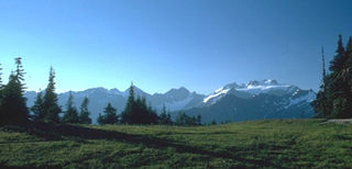
The Olympic Mountains are a mountain range on the Olympic Peninsula of the Pacific Northwest of the United States. The mountains, part of the Pacific Coast Ranges, are not especially high – Mount Olympus is the highest at 7,980 ft (2,432 m); however, the eastern slopes rise out of Puget Sound from sea level and the western slopes are separated from the Pacific Ocean by the low-lying 20 to 35 km wide Pacific Ocean coastal plain. The western slopes are the wettest place in the 48 contiguous states. Most of the mountains are protected within the bounds of Olympic National Park and adjoining segments of the Olympic National Forest.
Superstition Mountain is a prominent mountain and regional landmark located in the Phoenix metropolitan area of Arizona, immediately east of Apache Junction and north of Gold Canyon. It anchors the west end of the federally designated Superstition Wilderness Area and is a popular outdoor recreation destination, home to numerous trails for hiking and horseback riding. The legend of the Lost Dutchman's Gold Mine centers around the mountain.
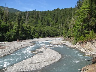
The Elwha River is a 45-mile (72 km) river on the Olympic Peninsula in the U.S. state of Washington. From its source at Elwha snowfinger in the Olympic Mountains, it flows generally north to the Strait of Juan de Fuca. Most of the river's course is within the Olympic National Park.
The Hoh River is a river of the Pacific Northwest, located on the Olympic Peninsula in the U.S. state of Washington. About 56 miles (90 km) long, the Hoh River originates at the Hoh Glacier on Mount Olympus and flows west through the Olympic Mountains of Olympic National Park and Olympic National Forest, then through the foothills in a broad valley, emptying into the Pacific Ocean at the Hoh Indian Reservation. The final portion of the Hoh River's course marks the boundary between the coastal segment of Olympic National Park and Olympic National Forest, the Hoh Indian Reservation.
Curecanti National Recreation Area is a National Park Service unit located on the Gunnison River in western Colorado. Established in 1965, Curecanti National Recreation Area is responsible for developing and managing recreational facilities on three reservoirs, Blue Mesa Reservoir, Morrow Point Reservoir and Crystal Reservoir, constructed on the upper Gunnison River in the 1960s by the U.S. Bureau of Reclamation to better utilize the vital waters of the Colorado River and its major tributaries. A popular destination for boating and fishing, Curecanti offers visitors two marinas, traditional and group campgrounds, hiking trails, boat launches, and boat-in campsites. The state's premiere lake trout and Kokanee salmon fisheries, Curecanti is a popular destination for boating and fishing, and is also a popular area for ice-fishing in the winter months.
Brown's Park or Browns Park, originally called Brown's Hole, is an isolated mountain valley along the Green River in Moffat County, Colorado and Daggett County, Utah in the United States. The valley begins in far eastern Utah, approximately 25 miles (40 km) downstream from Flaming Gorge Dam, and follows the river downstream into Colorado, ending at the Gates of Lodore in Dinosaur National Monument. Known as a haven for outlaws such as Butch Cassidy and Tom Horn during the late 19th century and the early 20th century, it is now the location of the Browns Park National Wildlife Refuge. It was also the birthplace of Ann Bassett. She and her sister Josie Bassett, were considered female outlaws and girlfriends to several of Cassidy's Wild Bunch gang. It is the location of John Jarvie Historic Ranch, where, in 1880, Scotsman John Jarvie built a ranch along the Green River.
The Hells Canyon Wilderness is a wilderness area in the western United States, in Idaho and Oregon. Created 48 years ago in 1975, the Wilderness is managed by both the U.S. Bureau of Land Management and the U.S. Forest Service and contains some of the most spectacular sections of the Snake River as it winds its way through Hells Canyon, North America's deepest river gorge and one of the deepest gorges on Earth. The Oregon Wilderness Act of 1984 added additional acreage and currently the area protects a total area of 217,927 acres (88,192 ha). It lies entirely within the Hells Canyon National Recreation Area except for a small 946-acre (383 ha) plot in southeastern Wallowa County, Oregon which is administered by the Bureau of Land Management. The area that is administered by the Forest Service consists of portions of the Wallowa, Nez Perce, Payette, and Whitman National Forests.
Drift Creek Wilderness is a 5,798-acre (2,346 ha) wilderness area in the Siuslaw National Forest on the Oregon Coast. It was created in 1984, along with two other small wilderness areas in the forest - Cummins Creek Wilderness and Rock Creek Wilderness. The elevation of Drift Creek ranges from 150 to 1,500 feet, and is characterized by long steep slopes with broken and uneven terrain. Drift Creek was named for the accumulations of driftwood on its banks.
The Salmon River is a 33.5-mile (53.9 km) river in the Cascade Range in the U.S. state of Oregon that drains part of southwestern Mount Hood. The entire length of the river is a protected National Wild and Scenic River. Several portions are in protected wilderness. It is affluent to the Sandy River, a tributary of the Columbia River.
The Elwha Dam was a 108-ft high dam located in the United States, in the state of Washington, on the Elwha River approximately 4.9 miles (7.9 km) upstream from the mouth of the river on the Strait of Juan de Fuca.
Glines Canyon Dam, also known as Upper Elwha Dam, built in 1927, was a 210-foot (64 m) high concrete arch dam built on the Elwha River within Olympic National Park, Clallam County, Washington.
The Humes Ranch cabin was built around the year 1900 by William Humes. William Humes was originally from New York and arrived in the Elwha River area en route to the Klondike. William, his brother, and a cousin liked the area so much they set up homestead sites. In the early 1940s, Herb Crisler settled into the cabin at Humes Ranch with his bride, Lois, while they filmed wildlife for what became Walt Disney's "Olympic Elk" film. Since acquiring the property from Peninsula Plywood, the National Park Service has restored the cabin, conforming to its original appearance and with much of the original materials. Wood deterioration, however, is occurring, as a result of the moist Olympic Peninsula environment.
There are many diverse trails within Olympic National Park. These trails traverse many different biomes, allowing hikers to explore from the coast of the Pacific Ocean to the summit of Mount Olympus. The trails vary in length from less than a mile and a few minutes hike to many miles and multiple days. The Pacific Northwest National Scenic Trail traverses the park from east to west, and has approximately 135 miles within its borders. The trails are divided into five separate areas, Staircase/Dosewallips Trails, Hurricane/Elwha Trails, Quinault/ Queets Trails, Hoh/Bogachiel/Sol Duc Trails, and Coastal Routes.
Goblins Gate, or Goblin Gates, is a narrow gorge, about 20 feet (6.1 m) across, on the Elwha River in the U.S. state of Washington. It is located in Olympic National Park where the Elwha River enters Rica Canyon, 8.9 kilometres (5.5 mi) east-southeast of Olympic Hot Springs.
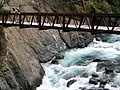
Dodger Point Bridge is a pedestrian suspension bridge 875 feet (267 m) above sea level, located above the Elwha River as it exits the Grand Canyon of the Elwha just past Humes Ranch Cabin, in Washington state, United States. It can be accessed approximate 3.5 miles (5.6 km) from the Whiskey Bend trailhead and is the point where the Geyser Valley trail ends. From the bridge, it is an 11-mile (18 km) hike up to the summit of Dodger Point at 5,753 feet (1,754 m).
The Grand Canyon of the Elwha is a deep canyon on the Elwha River located below Dodger Point approximately 5 miles (8.0 km) upstream from the now-drained Lake Mills in Washington, United States. It can be reached approximately 3.5 miles (5.6 km) from the Whiskey Bend trailhead via the Geyser Valley trail. It is also about 1⁄2 mile (0.80 km) from Humes Ranch Cabin and 1.4 miles (2.3 km) from Goblins Gate.
Krause Bottom is a riparian forest area on the Elwha River along the Geyser Valley trail in Olympic National Park, Washington. It contains a forest of bigleaf maple, red alder, and black cottonwood. The area around it was initially cleared by homesteaders in the late 1890s, but evidence of their activities is difficult to see today.
Oak Creek is a tributary, about 3.5 miles (5.6 km) long, of Marys River in Benton County in the U.S. state of Oregon. The stream descends from forested hills north of Corvallis through the northwest part of the city and across the campus of Oregon State University.
Frustration Falls, is a three drop waterfall located on the Salmon River at the south skirt of the Mount Hood National Forest, in Clackamas County, in the U.S. state of Oregon. It is located in a privileged area where the river creates several waterfalls: Final Falls, Vanishing Falls, Little Niagara Falls, and Copper Creek Falls are within a mile from Frustration Falls; while Hideaway Falls, Split Falls, and Stein Falls are approximately two miles away.
This page is based on this Wikipedia article Text is available under the CC BY-SA 4.0 license; additional terms may apply. Images, videos and audio are available under their respective licenses.