
A cave or cavern is a natural void under the Earth's surface. Caves often form by the weathering of rock and often extend deep underground. Exogene caves are smaller openings that extend a relatively short distance underground. Caves which extend further underground than the opening is wide are called endogene caves.

The Zagros Mountains are a long mountain range in Iran, northern Iraq, and southeastern Turkey. The mountain range has a total length of 1,600 km. The Zagros range begins in northwestern Iran and roughly follows Iran's western border while covering much of southeastern Turkey and northeastern Iraq. From this border region, the range continues southeast to the waters of the Persian Gulf. It spans the southern parts of the Armenian highlands, and the whole length of the western and southwestern Iranian plateau, ending at the Strait of Hormuz. The highest point is Mount Dena, at 4,409 metres (14,465 ft).

A cenote is a natural pit, or sinkhole, resulting when a collapse of limestone bedrock exposes groundwater. The term originated on the Yucatán Peninsula of Mexico, where the ancient Maya commonly used cenotes for water supplies, and occasionally for sacrificial offerings. The name derives from a word used by the lowland Yucatec Maya—tsʼonoʼot—to refer to any location with accessible groundwater.

Kermanshah is a city in the Central District of Kermanshah province, Iran, serving as capital of the province, the county, and the district. The city is 525 kilometres from Tehran in the western part of the country. The 2016 National Census measured the population of the city as 946,651.

Khao Sam Roi Yot National Park is a marine national park in Kui Buri District, Prachuap Khiri Khan Province, Thailand. It covers 61,300 rai ~ 98 square kilometres (38 sq mi) of which 13,050 rai ~ 21 square kilometres (8.1 sq mi) are marine areas. The park was established in 1966, and was the first coastal national park of Thailand. The park includes Thailand's largest freshwater marsh.

Tangeh Bolāghi, also transliterated as Tange-ye Bolāghi, or Bolāghi Gorge, is an archaeologically significant valley consisting of 130 ancient settlements, dating back to the period between 5000 BCE and the Sassanian dynastic era. It is situated in Iran’s southern province of Fars, some 7 kilometres from Pasargadae, Iran. This is the valley of the Polvar River, a tributary to Kor River.

The castle of Ziwiyeh or Ziwiyeh Castle is an ancient building situated on the top of a mount above the wide Ziwiyeh Cave in Saqqez, Iran. Ziwiye tepe or castle is located 50 kilometers to Saqqez and the area now have been Somewhat rebuilt by Iranian Cultural Heritage Organization. It is located at an altitude of 1,835 metres (6,020 ft) above sea level in Kurdistan province of Iran on the south of Lake Urmia. Artefacts found there belong to the 9th century BC and have been kept in some museums. A large golden necklace with some mythical animals engraved on it is one of the most famous things found in the area.

Darreh Shahr County is in Ilam province, Iran. Its capital is the city of Darreh Shahr.

Lefka Ori or Madares is a mountain range located in Western Crete, in the Chania prefecture. The White Mountains or Lefka Ori occupy a large part of the centre of West Crete and are the main feature of the region. They consist mainly of limestone, from light grey to bluish or black color. The White Mountains have taken their name from the perpetual white or off-white color of their peaks as the off white of limestone during the summer and fall interchanges with the snow that covers the peaks until late in spring.

Eldon Hill is a hill in the Peak District National Park in the county of Derbyshire, England, 4 kilometres (2.5 mi) southwest of the village of Castleton. It is a 470-metre (1,540 ft) limestone hill whose pastureland is used for rough grazing, although a large proportion has been lost to limestone quarrying. It lies within the Castleton Site of Special Scientific Interest. Eldon Hill was formed when a bed of pure limestone was squeezed and upfolded by geological forces to form a dome; it is the highest limestone hill north of the River Wye.

The Minatogawa Man or Minatogawa specimens are the prehistoric population of Okinawa, Japan, represented by four skeletons, two male and two female, and some isolated bones dated between 20,000 and 22,000 years BCE. They are among the oldest skeletons of hominins yet discovered in Japan.

The Alborz range, also spelled as Alburz, Elburz or Elborz, is a mountain range in northern Iran that stretches from the border of Azerbaijan along the western and entire southern coast of the Caspian Sea and finally runs northeast and merges into the smaller Aladagh Mountains and borders in the northeast on the parallel mountain ridge Kopet Dag in the northern parts of Khorasan. All these mountains are part of the much larger Alpide belt. The Alborz range is divided into the Western, Central, and Eastern Alborz Mountains. The Western Alborz Range runs south-southeastward almost along the western coast of the Caspian Sea. The Central Alborz runs from west to east along the entire southern coast of the Caspian Sea, while the Eastern Alborz Range runs in a northeasterly direction, toward the northern parts of the Khorasan region, southeast of the Caspian Sea. Mount Damavand, the highest mountain in Iran measuring 5,610.0 m, is located in the Central Alborz Mountains. Mount Damavand is the 12th most prominent peak in the world and the second most prominent in Asia after Mount Everest.
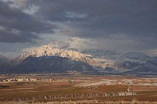
Porow Cave is a limestone cave in the Zagros Mountains, north of Kermanshah in Western Iran. At 751 m deep, it is the deepest cave in Iran. Joujar Cave has been reported as the second deepest, at 568 m deep.

The prehistory of the Iranian plateau, and the wider region now known as Greater Iran, as part of the prehistory of the Near East is conventionally divided into the Paleolithic, Epipaleolithic, Neolithic, Chalcolithic, Bronze Age and Iron Age periods, spanning the time from the first settlement by archaic humans about a million years ago until the beginning of the historical record during the Neo-Assyrian Empire, in the 8th century BC.

Darreh Shahr is a city in the Central District of Darreh Shahr County, Ilam province, Iran, serving as capital of both the county and the district. Darreh Shahr is in the southeastern part of the province, in the northern foothills of the Kabir Kuh ranges. According to the 2016 census there are 21,900 residents, making it the second-largest city in the province.
The Ōpārara Basin is a basin drained by the Ōpārara River at 20 kilometres (12 mi) north of Karamea, at the West Coast Region of the South Island of New Zealand. With its large natural rock arches, a network of caves rich in fossils, and a beautiful, unspoiled natural environment typical of temperate rainforests, it is one of the most striking places of the Kahurangi National Park.
The Sam Poh Tong Temple is a Chinese temple built within a limestone cave and is the oldest and the main cave temple in Ipoh, Perak, Malaysia. The temple was built in a raw limestone cave in the mountains located about 5 km from the city centre and follows Mahāyāna Buddhism.
Parâw is a mountain located to the north east of Kermanshah city in western Iran. Parâw, with an approximate length of 80 km and an area of 880 square kilometres is part of the Zagros Mountains. Paraw is one of the 1515 Ultra-prominent peak of the world.

Cave diving is underwater diving in water-filled caves. The equipment used varies depending on the circumstances, and ranges from breath hold to surface supplied, but almost all cave diving is done using scuba equipment, often in specialised configurations with redundancies such as sidemount or backmounted twinset. Recreational cave diving is generally considered to be a type of technical diving due to the lack of a free surface during large parts of the dive, and often involves planned decompression stops. A distinction is made by recreational diver training agencies between cave diving and cavern diving, where cavern diving is deemed to be diving in those parts of a cave where the exit to open water can be seen by natural light. An arbitrary distance limit to the open water surface may also be specified. Despite the risks, water-filled caves attract scuba divers, cavers, and speleologists due to their often unexplored nature, and present divers with a technical diving challenge.


