Related Research Articles
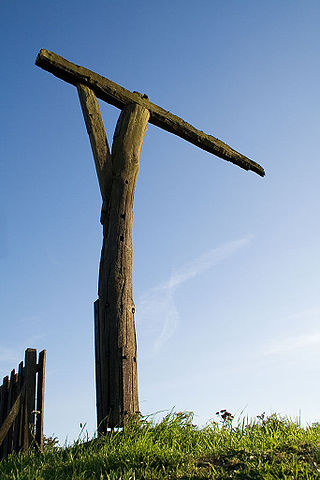
Gibbeting is the use of a gallows-type structure from which the dead or dying bodies of criminals were hanged on public display to deter other existing or potential criminals. Occasionally, the gibbet was also used as a method of public execution, with the criminal being left to die of exposure, thirst and/or starvation. The practice of placing a criminal on display within a gibbet is also called "hanging in chains".
The Bermuda National Trust is a charitable organization which works to preserve and protect the heritage of Bermuda.

Sandys Parish ( "sands") is one of the nine parishes of Bermuda. It is named for English aristocrat Sir Edwin Sandys (1561–1629), and hence there is no apostrophe in the name.

Southampton Parish is one of the nine parishes of Bermuda. It is named for Henry Wriothesley, 3rd Earl of Southampton (1573-1624).

Devonshire Parish is one of the nine parishes of Bermuda. Originally named Cavendish Tribe and later Devonshire Tribe, for William Cavendish, 1st Earl of Devonshire (1552–1626). Devonshire Redoubt, on Castle Island, one of the Castle Harbour fortifications of St. George's Parish, was also named after him.

Smith's Parish is one of the nine parishes of Bermuda. It is named for English aristocrat Sir Thomas Smith or Smythe (1558–1625).

Hamilton Parish is one of the nine parishes of Bermuda. It was renamed for Scottish aristocrat James Hamilton, 2nd Marquess of Hamilton (1589–1625) when he purchased the shares originally held in the Virginia Company by Lucy Russell, Countess of Bedford.
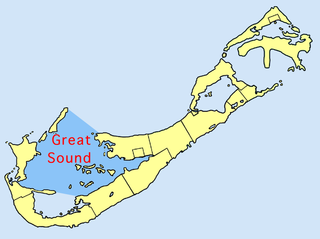
The Great Sound is large ocean inlet located in Bermuda. It may be the submerged remains of a Pre-Holocene volcanic caldera. Other geologists dispute the origin of the Bermuda Pedestal as a volcanic hotspot.
Darrell's Island is a small island within the Great Sound of Bermuda. It lies in the southeast of the sound, and is in the north of Warwick Parish. The island is owned by the Bermuda Government.

Somerset Bridge is a small bridge in Bermuda connecting Somerset Island with the mainland in the western parish of Sandys, Somerset Bridge is reputedly the smallest working drawbridge in the world. It crosses a small channel connecting the Great Sound with Ely's Harbour.

Harrington Sound is a large inland body of water in the northeast of the main island of Bermuda. It is surrounded by the main island on all sides, only appearing open to the ocean via a small channel called Flatt's Inlet in the southwest. Much of the sound's water flows to and from the ocean via cavern systems, notably Crystal Cave and Leamington Cave.
Flatt's Inlet is a small channel in Bermuda which joins Harrington Sound with the Atlantic Ocean. It lies almost exactly between the territory's two municipalities, Hamilton and St. George's.
Flatts Village is a small settlement in Bermuda, lying on the southern bank of Flatt's Inlet in Hamilton Parish, almost exactly between the territory's two incorporated municipalities, Hamilton and St. George's.

Castle Harbour is a large natural harbour in Bermuda. It is located between the northeastern end of the main island and St. David's Island. Originally called Southampton Port, it was renamed as a result of its heavy fortification in the early decades of the Seventeenth century.
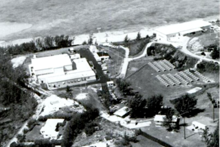
Naval Facility Bermuda, or NAVFAC Bermuda, was the operational shore terminus for one of the Atlantic Sound Surveillance System (SOSUS) array systems installed during the first phase of system installation and in commission from 1955 until 1992. The true surveillance mission was classified and covered by "oceanographic research" until the mission was declassified in 1991. The system's acoustic data was collected after the facility was decommissioned until the system was routed to the central processing facility, the Naval Ocean Processing Facility (NOPF), Dam Neck, Virginia in 1994.

The Roman Catholic Diocese of Hamilton in Bermuda is a diocese of the Latin Church of the Catholic Church in North America. The diocese comprises the entirety of the dependency of Bermuda. The diocese is a suffragan of the Archdiocese of Nassau, and a member of the Antilles Episcopal Conference.

The Bermuda Railway was a 21.7-mile (34.9 km) common carrier line that operated in Bermuda for a brief period. In its 17 years of existence, the railway provided frequent passenger and freight service over its length spanning most of the archipelago from St. George's in the east to Somerset, Sandys Parish, in the west.

Somerset Village is a small, unincorporated village in the northwest area of Bermuda, located in Sandys Parish. It lies in the northern half of Somerset Island.

Several of the islands strung across the South entrance of Castle Harbour, Bermuda were fortified in the early days of the territory, hence the harbour's name. When official settlement of the archipelago by England began in 1612 the first permanent town, St. George's was placed on the North side of St. George's Harbour. St. George's Harbour could be accessed directly by channels from the East. Those channels, however, were shallow, suitable, originally, only for small ships. As a consequence, and despite any major settlement on its shores, Castle Harbour was an important anchorage in the early years of the colony, with its main entrance, Castle Roads being an important route in from the open Atlantic for shipping. It was also a weak point, as it was remote from the defences of St. George's Harbour, and difficult to reach. It was quickly fortified and garrisoned by a standing militia.

The following is an alphabetical list of topics related to the British Overseas Territory of the Bermuda Islands.
References
- 1 2 Philpott, Don; Watkins, George (2000). Bermuda. Hunter Publishing, Inc. p. 58. ISBN 9781843060390.
- ↑ Jones, Rosemary (19 June 2018). Moon Bermuda. Hachette UK. p. 289. ISBN 9781631219870.
32°19.4′N64°44.6′W / 32.3233°N 64.7433°W
| | This Bermuda location article is a stub. You can help Wikipedia by expanding it. |
| | This article related to the African diaspora is a stub. You can help Wikipedia by expanding it. |