Hesse or Hessia, officially the State of Hesse, is a state in Germany. Its capital city is Wiesbaden, and the largest urban area is Frankfurt, which is also the country's principal financial centre. Two other major historic cities are Darmstadt and Kassel. With an area of 21,114.73 square kilometers and a population of over six million, it ranks seventh and fifth, respectively, among the sixteen German states. Frankfurt Rhine-Main, Germany's second-largest metropolitan area, is mainly located in Hesse.

Fulda is a city in Hesse, Germany; it is located on the river Fulda and is the administrative seat of the Fulda district (Kreis). In 1990, the city hosted the 30th Hessentag state festival.
Bad Kissingen is a Landkreis (district) in Bavaria, Germany. It is bounded by the district Main-Kinzig and Fulda in Hesse, and the districts of Rhön-Grabfeld, Schweinfurt and Main-Spessart.
The Fulda District is a Kreis (district) in the north-east of Hesse, Germany. Neighboring districts are Hersfeld-Rotenburg, Wartburgkreis, Schmalkalden-Meiningen, Rhön-Grabfeld, Bad Kissingen, Main-Kinzig, Vogelsbergkreis.
Schwalm-Eder-Kreis is a Kreis (district) in the north of Hesse, Germany. Neighbouring districts are Kassel, Werra-Meißner, Hersfeld-Rotenburg, Vogelsberg, Marburg-Biedenkopf, and Waldeck-Frankenberg.

The Fulda is a river of Hesse and Lower Saxony, Germany. It is one of two headstreams of the Weser. The Fulda is 220.4 kilometres (137.0 mi) long.

The Rhön Mountains are a group of low mountains in central Germany, located around the border area where the states of Hesse, Bavaria and Thuringia come together. These mountains, which are at the extreme southeast end of the East Hesse Highlands, are partly a result of ancient volcanic activity. They are separated from the Vogelsberg Mountains by the river Fulda and its valley. The highest mountain in the Rhön is the Wasserkuppe, which is in Hesse. The Rhön Mountains are a popular tourist destination and walking area.

Melsungen is a small climatic spa town in the Schwalm-Eder district in northern Hesse, Germany. In 1987, the town hosted the 27th Hessentag state festival. The Braun family’s 8 billionaires make Melsungen the city with the highest number of billionaires per capita in the world.

Hersfeld Abbey was an important Benedictine imperial abbey in the town of Bad Hersfeld in Hesse, Germany, at the confluence of the rivers Geisa, Haune and Fulda. The ruins are now a medieval festival venue.
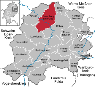
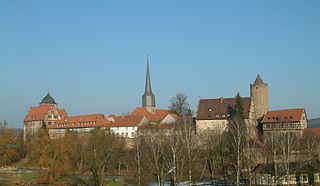
Rotenburg an der Fulda is a town in Hersfeld-Rotenburg district in northeastern Hesse, in central Germany, situated, as the name says, on the river Fulda.
Schlitz is a small town in the Vogelsbergkreis in eastern Hesse, Germany.

Eichenzell is a municipality in the district of Fulda, in Hesse, Germany. It is situated on the river Fulda, 7 km south of the town Fulda.

Gersfeld is a town in the district of Fulda, in Hesse, Germany. It is situated on the Fulda River, in the Rhön Mountains, 20 km (12.43 mi) southeast of Fulda. It belonged to the abbey-principality of Fulda before secularisation in 1803. It then belonged to the Principality of Nassau-Orange-Fulda between 1803 and 1806, to France between 1806 and 1810, and then later to the Grand Duchy of Frankfurt between 1810 and 1813. After the Battle of Leipzig, it was occupied by the Allied troops of the Sixth Coalition between 1813 and 1815. After that, it was ceded to the Kingdom of Bavaria in 1815. During the Austro-Prussian War, it was occupied by Prussia before its annexation in the newly established Hesse Nassau province. It was finally incorporated in the state of Hesse in 1945.

The West Hesse Depression is part of the West Hesse Highlands and Lowlands region in the north of the German state of Hesse. Like the East Hesse Depression, it is a series of separate depressions that form a natural corridor and have been an important historical trade route.
The East Hesse Highlands describes a heavily wooded range of hills lying mainly in the German state of Hesse, but also extending a little way into Lower Saxony to the north, Thuringia to the east and Bavaria to the southeast. The region is sandwiched between the West Hesse Depression to the west, the Weser Uplands to the north, the Thuringian Basin to the northeast, the northwestern edge of the Thuringian Forest to the east, the Spessart to the south and the Wetterau to the southwest.

Lower Hesse is a historic designation for an area in northern Hesse, Germany.

Lüder is a river of Hesse, Germany. It flows into the Fulda river northwest of Fulda town. Its source is in the upland bog of the Völzberger Köpfchen.
East Hesse is a common but not unofficial regional name for the eastern part of the German state of Hesse as well as a regional planning region. It corresponds roughly to the Hessian catchment area of Fulda and its heart covers the county of Fulda, the eastern part of the county of Vogelsbergkreis and the old counties of Hersfeld and Schlüchtern, but there is no clear boundary of East Hesse with North Hesse, Middle Hesse and South Hesse. In older sources, a landscape, roughly identical with the current East Hesse area, was commonly called Buchonia.

The is a large volcanic mountain range in the German Central Uplands in the state of Hesse, separated from the Rhön Mountains by the Fulda river valley. Emerging approximately 19 million years ago, the Vogelsberg is Central Europe's largest basalt formation, consisting of a multitude of layers that descend from their peak in ring-shaped terraces to the base.

