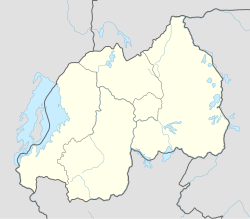
Rwanda, officially the Republic of Rwanda, is a landlocked country in the Great Rift Valley of Central Africa, where the African Great Lakes region and Southeast Africa converge. Located a few degrees south of the Equator, Rwanda is bordered by Uganda, Tanzania, Burundi, and the Democratic Republic of the Congo. It is highly elevated, giving it the soubriquet "land of a thousand hills", with its geography dominated by mountains in the west and savanna to the southeast, with numerous lakes throughout the country. The climate is temperate to subtropical, with two rainy seasons and two dry seasons each year. It is the most densely populated mainland African country; among countries larger than 10,000 km2, it is the fifth-most densely populated country in the world. Its capital and largest city is Kigali.
Human occupation of Rwanda is thought to have begun shortly after the last ice age. By the 11th century, the inhabitants had organized into a number of kingdoms. In the 19th century, Mwami (king) Rwabugiri of the Kingdom of Rwanda conducted a decades-long process of military conquest and administrative consolidation that resulted in the kingdom coming to control most of what is now Rwanda. The colonial powers, Germany and Belgium, allied with the Rwandan court.
The Hutu, also known as the Abahutu, are a Bantu ethnic or social group which is native to the African Great Lakes region. They mainly live in Rwanda, Burundi and the eastern Democratic Republic of the Congo, where they form one of the principal ethnic groups alongside the Tutsi and the Great Lakes Twa.
The Tutsi, also called Watusi, Watutsi or Abatutsi, are an ethnic group of the African Great Lakes region. They are a Bantu-speaking ethnic group and the second largest of three main ethnic groups in Rwanda and Burundi.

The Rwandan genocide, also known as the genocide against the Tutsi, occurred between 7 April and 19 July 1994 during the Rwandan Civil War. During this period of around 100 days, members of the Tutsi minority ethnic group, as well as some moderate Hutu and Twa, were killed by armed Hutu militias. Although the Constitution of Rwanda states that more than 1 million people perished in the genocide, the actual number of fatalities is unclear, and some estimates suggest that the real number killed was likely lower. The most widely accepted scholarly estimates are around 500,000 to 800,000 Tutsi deaths.
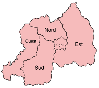
The provinces of Rwanda are divided into districts (akarere) and municipalities (umujyi). Prior to January 1, 2006, Rwanda was composed of 12 provinces. The Rwandan government decided to establish new provinces in an attempt to address issues that arose from the Rwandan genocide. The new provinces were to be "ethnically-diverse administrative areas".

The Burundian Civil War was a civil war in Burundi lasting from 1993 to 2005. The civil war was the result of longstanding ethnic divisions between the Hutu and the Tutsi ethnic groups. The conflict began following the first multi-party elections in the country since its independence from Belgium in 1962, and is seen as formally ending with the swearing-in of President Pierre Nkurunziza in August 2005. Children were widely used by both sides in the war. The estimated death toll stands at 300,000.
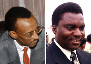
The Rwandan Civil War was a large-scale civil war in Rwanda which was fought between the Rwandan Armed Forces, representing the country's government, and the rebel Rwandan Patriotic Front (RPF) from 1 October 1990 to 18 July 1994. The war arose from the long-running dispute between the Hutu and Tutsi groups within the Rwandan population. A 1959–1962 revolution had replaced the Tutsi monarchy with a Hutu-led republic, forcing more than 336,000 Tutsi to seek refuge in neighbouring countries. A group of these refugees in Uganda founded the RPF which, under the leadership of Fred Rwigyema and Paul Kagame, became a battle-ready army by the late 1980s.
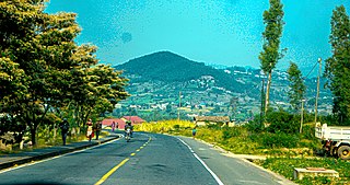
Kibeho is a sector and small town in south Rwanda, which became known outside of that country because of reported apparitions of the Blessed Virgin Mary and Jesus Christ occurring between 1981 and 1989. It is also known for the Kibeho Massacre in April 1995, when several thousand internally displaced people were killed by the Rwandan Patriotic Army.

Gitarama was one of the former twelve provinces (intara) of Rwanda and was situated in the centre of the country, to the west of the capital Kigali. Gitarama Prefecture was created in 1959, increasing the number of prefectures of Rwanda from eight to nine. In 2002, it was renamed a province, as were the other prefectures of Rwanda. It had an area of 2,187 square kilometres and a population of some 851,451 prior to its dissolution in January 2006. Gitarama was divided into 8 districts: Muhanga, Kayumbu, Kabagali, Ntenyo, Kamonyi, Ntongwe, Ndiza and Ruyumba; and two towns: Ruhango and Gitarama. Gitarama bordered the provinces Butare, Gikongoro, Kibuye, Gisenyi, Ruhengeri, Kigali-Ngali and Kigali City Tourist attractions included the Kamegeri rocks and the Busaga forest.
The five provinces of Rwanda are divided into 30 districts. Each district is in turn divided into sectors, which are in turn divided into cells, which are in turn divided into villages.
Charles Munyaneza is a Rwandan man living in the Putnoe area of Bedford, England.
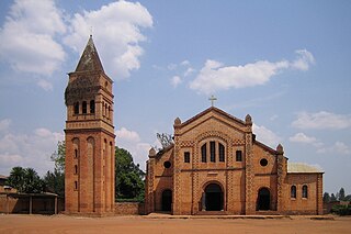
Christianity is the largest religion in Rwanda. The most recent national census from 2012 indicates that: 43.7% of Rwanda's population is Catholic, 37.7% is Protestant, 11.8% is Seventh-day Adventist, 2.0% is Muslim, 2.5% claims no religious affiliation, and 0.7% is Jehovah's Witness.

Human rights in Rwanda have been violated on a grand scale. The greatest violation is the Rwandan genocide of Tutsi in 1994. The post-genocide government is also responsible for grave violations of human rights.

Gikongoro Province was one of the former twelve provinces (intara) of Rwanda and is situated in the southwest of the country. The former province had an area of some 2,146 square kilometers. Its population was estimated at 466,451 (1990) and 511,776 (2002) prior to its dissolution in January 2006, with an annual growth rate of .810% between the years of 1990 and 2002. It included 13 "communes" and 125 sectors.

Gatare is a town in Rwanda, Central Africa, capital of the homonymous sector in the district of Nyamagabe. The location is 2°22′04.08″S29°22′52.15″E. It is located in the southern province of the country, around 2500 m. altitude on the mountains bordering the equatorial forest of Nyungwe. The territory is mostly covered by forest and is intensively cultivated by the population. The climate is equatorial, with heavy and abundant rains from February to April and during the period between September and November, while the period between June and August, the most critical for the population, is characterized by drought.
During the Rwandan genocide of 1994, over the course of 100 days, up to half a million women and children were raped, sexually mutilated, or murdered. The International Criminal Tribunal for Rwanda (ICTR) handed down the first conviction for the use of rape as a weapon of war during the civil conflict, and, because the intent of the mass violence against Rwandan women and children was to destroy, in whole or in part, a particular ethnic group, it was the first time that mass rape during wartime was found to be an act of genocidal rape.
Jean-Baptiste Habyalimana was a Rwandan academic and politician who served as the Prefect of Butare and was killed during the Rwandan genocide in 1994. He was the only Tutsi prefect at the time of the genocide, and also the only prefect belonging to the Liberal Party. He had resisted the genocide.
François Bazaramba is a Rwandan sentenced to life imprisonment in Finland for participating in the Rwandan genocide in 1994. The Bazaramba case is historic in Finnish legal history because it was the first time anyone was sentenced under Finland's "crimes against humanity" laws since the international norms against genocide were implemented in national law. The case was appealed up to the Supreme Court of Finland, which upheld the conviction.
The International Commission of Investigation on Human Rights Violations in Rwanda since October 1, 1990 was an international inquiry that investigated reported human rights abuses during the Rwandan Civil War. Sponsored by four international non-governmental organizations, the commission was not officially mandated by the Rwandan government. Ten commissioners from eight countries spent two weeks in Rwanda visiting prefectures and documenting oral and written accounts, along with exhuming reported locations of mass grave burials. Primarily, the inquiry examined three major massacres that occurred between 1990 and 1992. The commission lasted three months and the final report was released in March 1993. Due to the dates of its investigation, the commission does not cover the Rwandan genocide, which followed in April 1994.

