The Hasbani or Snir Stream, is the major tributary of the Jordan River. Native people in the mid-19th century knew the Hasbani as the Upper Jordan River.

Avnei Eitan is an Israeli settlement organized as a moshav in the southern Golan Heights, located at an elevation of 385 meters (1,263 ft) above sea level. Located to the east of the Sea of Galilee, it falls under the municipal jurisdiction of Golan Regional Council. In 2022 it had a population of 876. It is part of the Hapoel HaMizrachi movement.

Nimrod is a small Israeli settlement organized as a moshav, in the Golan Heights on the southern slopes of Mount Hermon, and is the highest such civilian settlement in Israeli-controlled territory at 1,110 meters (3,640 ft) above sea level. Located near the Israeli settlement of Neve Ativ and the Druze towns of Majdal Shams, Mas'ade, and Ein Qiniyye, it falls under the jurisdiction of Golan Regional Council. In 2019 it had a population of 16.

Wadi Gaza and Besor Stream are parts of a river system in the Gaza Strip and Negev region of Palestine and Israel. Wadi Gaza is a wadi that divides the northern and southern ends of the Gaza Strip, its major tributary is Besor Steam. In 2022 work began to rehabilitate Wadi Gaza Nature Reserve.

Magal is a kibbutz in Israel. Located in the Wadi Ara region of the northern Sharon plain near the Green Line, it falls under the jurisdiction of Menashe Regional Council. In 2022 it had a population of 1,219. The kibbutz was named after the sickle on the Nahal's badge.

Eli-ad is an Israeli settlement organized as a moshav in the southern Golan Heights. It falls under the jurisdiction of Golan Regional Council and in 2022 had a population of 496.

Kfar Adumim is a mixed religious-secular Israeli settlement in the West Bank. It is located in the Judean Desert, on the southern bank of Wadi Qelt, about 2 miles northeast of the town Ma'ale Adumim. It is at 367 meters above sea level. It is organized as a community settlement and falls under the jurisdiction of Mateh Binyamin Regional Council. In 2022 it had a population of 4,957. The Israel Central Bureau of Statistics counts the populations of nearby settlements Alon and Nofei Prat as part of the population of Kfar Adumim.

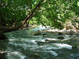
Nahal Amud, also known as the Wadi al-Amud, is a stream in the Upper Galilee region of Israel that flows into the Sea of Galilee.

Nahal Ayun, sometimes spelled Nahal Iyyon, in Arabic: براغيث Bureighit, or in full Nahr Bareighit, is a perennial stream and a tributary of the Jordan River. The stream originates from two springs in the Marjayoun valley in southern Lebanon, runs southward for seven kilometers through various irrigation ditches, then flows into Israel near Metulla, where it continues through the Hula Valley in the Galilee Panhandle until emptying in the Hasbani River just before it reaches the Jordan River.

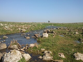
Nahal Gerar, also Nachal Grar is a wadi in Israel, in the Negev desert. Its Arabic name is Wadi esh-Sheri'a. Along this wadi, there are several important ancient Bronze Age archaeological sites. During the Early Iron Age this was an area of Philistine settlement.

Wadi Auja, also spelled Ouja, known in Hebrew as Nahal Yitav is a valley or stream, in the West Bank, originating near the Ein Samia spring and flowing to Al-Auja near Jericho before it runs into the Jordan River.
The Yehudiya Reserve is a nature reserve in the central Golan Heights. With the area of 134 sq. km, it is the largest reserve in the Golans. The height differential of its landscape - from 200 meters below the sea level to 600 meters above - provides for high waterfalls. It is named after the ancient village of Yehudiya, one of many archaeological sites located within the reserve. Due to the varied scenery of streams, gorges with waterfalls, woodlands, rich wildlife, and volcanic basalt landscape it is a popular tourist destination in Israel.
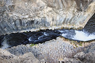
The Meshushim Stream is part of the Yehudiya Forest Nature Reserve in the Golan Heights. 35 km long, it starts from the foothills of Mount Avital and discharges via the Bethsaida Valley into the Sea of Galilee.

The Dishon Stream is an intermittent stream/wadi in Upper Galilee, Israel. It is 26 kilometers long, starts on the eastern slope of Mount Meron and drains into the Jordan River in the area of the drained Hula Lake. It is one of the largest streams in East Upper Galilee. Its name is a modification of the name of the depopulated Palestinian village of Dayshum.

Kfar Dvora was a Jewish settlement during the Talmudic period in the upper Gilbon River in the Golan Heights. At the site, remains of a Jewish settlement, synagogue, a Beth midrash, 5 inscriptions in Aramaic, 1 in Greek, and one in Hebrew were discovered, which was a novelty in research, as it indicated the existence of a Beth midrash in the place. Many decorated stones were also found, integrated into secondary construction and scattered in the area. On the ruins of Kfar Dvora, the Syrian village of Daburiya was established, which is currently abandoned. Before the Six-Day War, the village was inhabited by Bedouins of the Na'arna tribe, who made secondary use of the stones from the ancient Jewish settlement for construction purposes. The village is currently located northwest of the settlement of kidmat Tzvi.
Nahal Livnim is a tributary of Nahal Amud in the Upper Galilee region of northern Israel. The stream flows from west to east, with its upper part beginning at an elevation of 303 meters above sea level on the Livnim Ridge, south of Kfar Hananya, and it empties into Nahal Amud at an elevation of 11 meters below sea level near Khirbet Sirin in the Sirin Plateau.
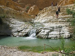
Nahal Arugot is a stream that drains many streams in the center of the Judean desert. The stream is a popular hiking destination located in the Ein Gedi Nature Reserve in Israel. The area offers various hiking trails, suitable for different levels of hikers, and features landscapes, water streams, waterfalls, and historical sites. There are two primary hiking routes in Nahal Arugot: a shorter, family-friendly trail and a longer, more challenging circuit.

Nahal David is a perennial stream that flows through the Ein Gedi Nature Reserve in the southeastern Judean Desert.
Nahal Gush Halav is a short, intermittent stream in the Upper Galilee, originating at an elevation of approximately 830 meters above sea level, near Lake Dalton, and ending at its confluence with Nahal Dishon.

