
Attalla is a city in Etowah County, Alabama, United States. As of the 2010 census, the population was 6,048.

Gadsden is the county seat of Etowah County in the U.S. state of Alabama. It is located on the Coosa River about 56 miles (90 km) northeast of Birmingham and 90 miles (140 km) southwest of Chattanooga, Tennessee. It is the primary city of the Gadsden Metropolitan Statistical Area, which has a population of 103,931. The population 33,945 at the 2020 census.

Reece City is a town in Etowah County, Alabama, United States. It was incorporated in May 1956. It is part of the Gadsden Metropolitan Statistical Area. At the 2020 census, the population was 615.
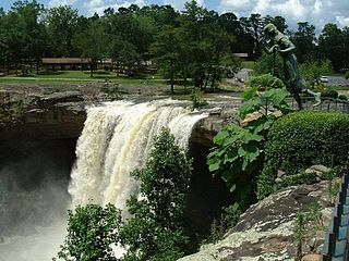
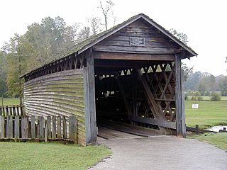
Noccalula Falls Park is a 250-acre (101-ha) public park located in Gadsden, Alabama, United States. The main feature of the park is a 90-foot (27-m) waterfall. Trails wind through Black Creek Gorge past caves, an aboriginal fort, an abandoned dam, pioneer homestead, and Civil War carvings. The park also features a petting zoo, mini-golf course, the Gilliland-Reese Covered Bridge and a replica 1863 C. P. Huntington train ride.

State Route 227 is a 39-mile-long (63 km) route that serves as a connection between the Etowah–DeKalb county line south of Crossville with U.S. Route 431 (US 431) at Guntersville in Marshall County.

Emma Sansom High School was a high school located in Gadsden, Alabama. It was named for a young girl who was credited with helping General Nathan Bedford Forrest to cross Black Creek in Gadsden, Alabama and get his troops ahead of Union troops, thus stopping an impending attack upon Rome, Georgia during the Civil War.
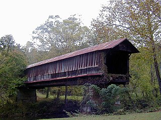
The Waldo Covered Bridge, also known as the Riddle Mill Covered Bridge, is a privately owned wood & metal combination style covered bridge that spans Talladega Creek in Talladega County, Alabama, United States. It is located off State Route 77 just south of the town of Waldo, about 6 miles southeast of Talladega. Coordinates are 33°22′44.78″N86°01′43.87″W.

The Swann Covered Bridge, also called the Joy Covered Bridge or Swann-Joy Covered Bridge, is a county-owned, wood-and-metal combination style covered bridge that spans the Locust Fork of the Black Warrior River in Blount County, Alabama, United States. It is located on Swann Bridge Road off State Route 79, just west of the town of Cleveland, about 10 miles (16 km) northwest of Oneonta.
The Coldwater Covered Bridge, also known as the Hughes Mill Covered Bridge, is a locally owned wooden covered bridge that spans the outflow from Oxford Lake in Calhoun County, Alabama, United States. It is located at Oxford Lake Park off State Route 21 in the city of Oxford, about 4 miles south of Anniston.

The Horton Mill Covered Bridge is a state-owned wooden covered bridge that spans the Calvert Prong of the Little Warrior River in Blount County, Alabama, United States. It is located on a river crossing to Ebell Road and Covered Bridge Circle, off State Route 75 about 5 miles (8.0 km) north of the city of Oneonta.
The Easley Covered Bridge, also known as the Old Easley Covered Bridge or Rosa Covered Bridge, is a county-owned wood and metal combination style covered bridge that spans Dub Branch of the Calvert Prong of the Little Warrior River in Blount County, Alabama, United States. It is located on Easley Bridge Road off U.S. Route 231, just south of the town of Rosa, about 5 miles northwest of Oneonta. Coordinates are 33°58′16″N86°31′07″W.

The Salem-Shotwell Covered Bridge, also known as the Pea Ridge Covered Bridge, is a locally owned wooden covered bridge that spans Rocky Brook in Lee County, Alabama, United States. It is located halfway down Park Road at Opelika Municipal Park, which is off North 5th Street in the city of Opelika. Coordinates are 32°39′33.46″N85°22′52.94″W.

The Alamuchee-Bellamy Covered Bridge is a county-owned wooden covered bridge that spans the northeast corner of Duck Pond in Sumter County, Alabama, United States. It is located on the campus of the University of West Alabama behind Reed Hall, which is off Student Union Drive in the city of Livingston.

The Old Union Crossing Covered Bridge is a privately owned wood & metal combination style covered bridge that spans the West Fork of the Little River in DeKalb County, Alabama, United States. It is located on an access road between Shady Grove Dude Ranch and Cloudmont Ski & Golf Resort on Lookout Mountain, which is off County Road 614 near the town of Mentone. Coordinates are 34°32′3.51″N85°35′56.47″W.
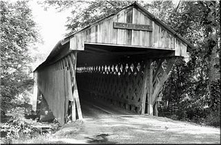
The Nectar Covered Bridge was a wood and metal combination style covered bridge which spanned the Locust Fork of the Black Warrior River in Blount County, Alabama, United States. It was located on Nectar Bridge Road off State Route 160, just east of the town of Nectar, about 14 miles northwest of Oneonta. Nectar Covered Bridge was at one time the seventh-longest covered bridge in the country. The bridge remained open to single lane motor traffic from its construction until it was burned by vandals on June 13, 1993.

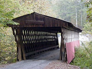
The Jack's Creek Covered Bridge, also known as the Upper Covered Bridge, is a county-owned wooden covered bridge that spans the Smith River in Patrick County, Virginia, United States. It is located on Jack's Creek Road (SR 615) off State Route 8 just south of the community of Woolwine, about 11 miles (18 km) north of Stuart.

State Route 211 is a 4.607-mile (7.414 km) state highway that serves as a connection between Gadsden and Interstate 59 (I-59) in Reece City in central Etowah County. SR 211 intersects US 278 and US 431 at its southern terminus and US 11 at its northern terminus.
The Lidy Walker Covered Bridge, formerly known as the Big Branch Covered Bridge, was a privately owned wood-&-metal combination style covered bridge which spanned the outlet to Lidy's Lake in Cullman County, Alabama, United States. It was located in the Berlin community at a pasture near the lake off Cullman County Road 1616 near U.S. Route 278, 6 miles east of the city of Cullman.
The Tallahatchee Covered Bridge, also known as the Prickett Covered Bridge, was a privately owned wood and metal combination style covered bridge which spanned a pond near Nances Creek in Calhoun County, Alabama, United States. It was located just off State Route 9, about 2 miles south of the city of Piedmont. Approximate coordinates were 33°53′16.13″N85°37′33.70″W.

