
The Ipswich Racecourse is an area of Ipswich in Suffolk, England, that was formerly a racecourse from 1710 to 1911.

Wortham is a village and parish in Suffolk, England, close to the border with Norfolk. Its church, St Mary the Virgin, lies about a mile north of the present-day village. It is one of 38 existing round-tower churches in Suffolk and the one with the greatest diameter in England.
Morpeth House is a large house in the east of Ipswich, England. It is situated on Lacey Street near the old Odeon. The grounds are about 3/4 of an acre and have many old trees and interesting features.

Martin & Newby was the oldest shop in Ipswich, Suffolk until it closed down in June 2004. The business was established in Fore Street in 1873 and was based around 5 departments: Ironmongery, Electrical, Domestic, Gardening and Tools. The shop gave a very traditional personal service, it was reported by local press that the shop closed down because they could not compete with DIY Superstores such as B&Q and the increasing range of products offered by supermarkets.
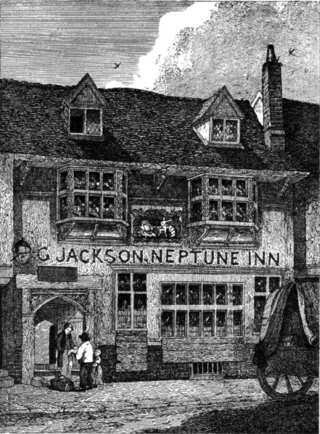
Neptune Inn is an historic public house located in Fore Street, Ipswich, Suffolk, England. The building was originally built around 1490 and is grade II* listed.

Richard Dykes Alexander was a businessman and philanthropist based in Ipswich, Suffolk.

St Clement's Church, Ipswich, is a redundant church. The church is one of twelve medieval churches in Ipswich, six of which had been declared redundant by the 1970s. In the twenty-first century it was taken over by Ipswich Historic Churches Trust.

John Dupuis Cobbold was a member of the Ipswich based Cobbold family.

The Steam Packet Inn was a public house located at 2/4 Duke Street, Ipswich, Suffolk, England. It closed on 18 September 1960. The building had been owned by Cobbold Brewery but after closure it was sold to Eastern Counties Farmers (ECF). The Burns family then lived there, Mr Burns being employed by ECF.
Ipswich and Suffolk Freehold Land Society (FLS) was founded in 1849 as part of the "forty-shilling freeholders movement" which developed across England. Its aim was to enable "the ordinary man" to obtain sufficient property to meet the requirements needed to gain the vote. The movement had been started by James Taylor of Birmingham. On Saturday 1 December 1849 the first meeting of the society was advertised in the Suffolk Chronicle. Richard Dykes Alexander, the head of the Alexander banking family, was the first president.
Charles Foote Gower was an English soap manufacturer based in Ipswich. He was a significant businessman in that town.

George Green Sampson (1804-1885) was a physician and politician in Ipswich, Suffolk.

John Speed's Ipswich is a graphic account of the town of Ipswich, Suffolk created by John Speed in conjunction with the Dutch engraver, Jodocus Hondius, in 1610. It was featured as an inset for his map of the county of Suffolk, published in Theatre of The Empire of Great Britaine. It is the earliest extant map of Ipswich and features many buildings of the late medieval period, whilst at the same time showing streets laid out in a grid pattern which has largely been retained into the twenty first century.

St George's Chapel, was a religious building located in Ipswich, Suffolk. The spot where it was located is now occupied by St George's Terrace, in St Georges Street. This lies just to the north of the historic town centre of Ipswich. It was from this chapel that Thomas Bilney was taken in 1527 and accused of heresy. No trace of the building remains.

Stoke Mill was an historic watermill located in Ipswich, Suffolk. It was located on the north bank of the River Orwell next to Stoke Bridge. It was on Bridge Street where there is now a skate park.
Christ's Hospital, Ipswich was established in Tudor Ipswich, Suffolk. The original benefactors were Robert Felaw, William Smarte and Henry Tooley.
Frederick Brett Russell was an English architect and artist based in Ipswich, Suffolk.

William Francis Paul was a business man in Ipswich, Suffolk who was active in politics and became a benefactor to the town.

St Mildred's Church, Ipswich was a parish church located at The Cornhill, Ipswich. It was dedicated to Saint Mildred, an Abbess of Thanet who died in the eighth century. The church was built shortly after her death, but became used as an administrative centre in the fourteenth century. Only a chapel was retained for religious use until the reformation.
