Girgenti House

Last updated

The Girgenti clocktower and the farm Girgentitower1.JPG
The Girgenti clocktower and the farm

Girgenti House (OS grid reference: NS 36502 43575) was a small, rather eccentric mansion built on part of the old Barony of Bonshaw in the parish of Stewarton, East Ayrshire, Scotland.

Contents

History

Bonnyton

Bonnyton, a part of the Barony of Bonshaw, had belonged to the Reids of Stacklawhill and also to several generations of the Watts family, who were joiners and cartwrights. Born there was Doctor Robert Watt, the eminent Scotsman who published the Bibliotheca Britannica in 1824, shortly before he died; [1] it records more than 200,000 books, pamphlets and periodicals printed from 1450 to the early nineteenth century and took him 25 years to compile. [2] His portrait hangs in the entrance hall of the Royal Faculty of Physicians and Surgeons of Glasgow, and his direct descendants still live in the Stewarton area. [3]

Girgenti House

View of the farm, tower and lodges from near Torranyard Girgenti Farm & lodges.JPG
View of the farm, tower and lodges from near Torranyard

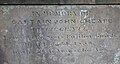
Captain John Cheape, the builder of Girgenti House, belonged to a Fife family represented by George C. Cheape, Esq., of Strathtyrum, and was the seventh son of James Cheape, Esq., of Sauchie, in Clackmannanshire. He was in the Scots Fusilier Guards and had served in the Napoleonic Wars. [4]

Bonnyton (not Muirhead as sometimes stated) was renamed Girgenti by the well-travelled Captain Cheape, perhaps in honour of a visit to the ancient Greek ruins of Agrigentum (the name of the town has become Girgenti in modern Sicilian). In 1827 he paid Thomas Reid £1350 [5] for the property, totalling 50 Scotch acres, and at a cost of £6000 he demolished the old Bonnyton farm steading and built a rather eccentric mansion house and offices and planted extensive plantations and shrubberies on what had been a wild moss-land. It is not known what brought him to the area or why he chose such a comparatively desolate site. [1] Moorhead is the original name given in the Lainshaw Register of Sasines for Girgenti. [6] A clue to his acquisition of these moss lands lies in the fact that The Royal Horticultural and Agricultural Society of Scotland awarded Cheape with an Honorary Silver Medal in 1833 for his publication entitled "Cultivation of Land by Manual Labour." [7]

Cheape had been an ensign in the 44th Regiment of Foot, then joined the 98th Regiment and next moving as a captain to the Royal Glasgow Regiment of Foot, 1800 saw him in the 3rd Regiment of Foot Guards and in 1803 he retired. [7]

Cheape lived at Girgenti for the last twenty years of his life (1829–1850) after leaving the army. [8] The house had a pillared portico and was basically single-storeyed in appearance, with bays, a capped tower and dormer windows on two different levels; it had a large summer house. [5] A conservatory was present and a sunken eight roomed storey for servants. [9]

The OS maps show associated buildings—presumably the mains or home farm and a coach house, stables, and so forth. The National Archives of Scotland hold a map of the estate made in 1845, surveyed by John Fairlie. [10]

The tower Girgenti tower.JPG
The tower

Cheape died unmarried at Girgenti on 10 February 1850, [5] aged 76, leaving James McAlister of Kennox to administer the lands of Girgenti. [7] The estate was sold to benefit a number of infirmaries across Scotland (Glasgow, Edinburgh, Aberdeen, Inverness and Dundee). [1] He was buried in the Laigh Kirk, Stewarton. Cheape's only sister, Marianne, who was first married to Sir Alexander Campbell of Ardkinglass in 1792, became the third wife of Thomas, 11th Earl of Strathmore and Kinghorne in 1817; their residence was Glamis Castle (where the Queen Mother would spend a great deal of her childhood and where Princess Margaret was born). She was to have inherited Girgenti; however, she predeceased her brother.

Cheape's tower

Cheape is said to have believed in reincarnation, or transmigration of the soul, and to have been so convinced that he would return in the form of a bird that next to his mansion house he built a large tower with an octagonal roof, housing a dovecote on top. Finished in 1843, it stands 80 feet (24 m) tall, has four clock faces, [11] his family coat of arms and a motto—Didus Fructus ("Let it spread its fruit abroad")—all on the outer surfaces. A shield on the tower records that it was "Designed and built by Captain John Cheape, 1843".

A local tale is that Captain Cheape was in league with smugglers and would light a lamp in the top of the tower when he knew the coast was clear. [12] The nearby ruins of Auchenharvie Castle and Darnshaw Farm are linked to stories of smuggling corpses for dissection by Glasgow medical students. [13] The tower bears a striking resemblance to the typical Italian 'Campanile' and this may reflect his interest in the Italian culture as indicated by the name 'Girgenti'. He is also said to have constructed the tower to be able see the ocean and finally the celebration of his 70th birthday could be the explanation for this folly.

Later owners and residents of Girgenti House

The West Lodge and remains of the old walled garden Girgenti walled garden.JPG
The West Lodge and remains of the old walled garden
The East Lodge Girgenti East lodge.JPG
The East Lodge

William Broom, an ironmaster in Glasgow, purchased the estate, after which it passed into the hands of Alexander Cochrane of Verreville in Lanarkshire. [5] The estate was later purchased by a Glasgow businessman, Allan Gilmour of Eaglesham, [14] for private use. The 1881 census records the coachman's house as being occupied by James Young of Glasgow and his wife, mother and six children. Christina Fergusson is recorded as a laundress living in the mansion house, as well as a Janetta R. Moffat from Dingwall. [15] [16]

In 1900 it was sold to Glasgow Corporation for use as a reformatory for female inebriates, which opened in January 1901. (That by 1903 seventy-one inmates had been treated there, with about forty-three in residence on the average, shows the scale of the condition at that time. [17] ) It had initially been intended for both men and women but became solely for women in 1901, with most of the committed women being paupers, about half of whom had been convicted for prostitution. [18]

After less than 10 years as a reformatory, the estate was sold again and transformed into a privately owned training centre for homeless boys between the ages of 14 and 20. It was next sold to the Scottish Labour Colony Association, which continued its use as a training centre. In 1918 it changed hands yet again, and this time it returned to farm use. The owner was now a Mr Muir, who was a great-grandson of the Thomas Reid of Stacklawhill from whom Cheape had purchased the estate in 1827.

The farm was next sold in 1932 to Mr Sword, chairman of the Western SMT Company, who took considerable interest in the outbuildings and had the tower restored and the clock repaired. The two Italianate lodges, East and West, survive, together with part of the walled garden; the house itself was demolished in the 1940s. The farm steading is mainly original; a cottage is also present. [5] A Mr and Mrs Smith owned and worked the farm from around 1960.

See also

Related Research Articles

<span class="mw-page-title-main">Stewarton</span> The Bonnet Toun

Stewarton is a town in East Ayrshire, Scotland. In comparison to the neighbouring towns of Kilmaurs, Fenwick, Dunlop and Lugton, it is a relatively large town, with a population estimated at over 7,400. It is 300 feet above sea level. The town is served by Stewarton railway station.

Chapeltoun is an estate on the banks of the Annick Water in East Ayrshire, a rural area of Scotland famous for its milk and cheese production and the Ayrshire or Dunlop breed of cattle.

Lambroughton is a village in the old Barony of Kilmaurs, Scotland. This is a rural area famous for its milk and cheese production and the Ayrshire or Dunlop breed of cattle.

<span class="mw-page-title-main">Clan Cunningham</span> Scottish clan

Clan Cunningham is a Scottish clan. The traditional origins of the clan are placed in the 12th century. However, the first contemporary record of the clan chiefs is in the thirteenth century. The chiefs of the Clan Cunningham supported Robert the Bruce during the Wars of Scottish Independence. In the 15th and 16th centuries, the Clan Cunningham feuded with the Clan Montgomery. Historically, the chief of Clan Cunningham held the title of Earl of Glencairn. However, in modern times the chief of the clan is Cunningham of Corsehill. On 18 December 2013, Sir John Christopher Foggo Montgomery Cunninghame, Baronet of Corsehill, was recognized by Lord Lyon as Clan Chief after the chiefship had been vacant for over 200 years.

<span class="mw-page-title-main">Barony and Castle of Corsehill</span> Barony in East Ayrshire, Scotland

The old Barony and castle of Corsehill lay within the feudal Baillerie of Cunninghame, near Stewarton, now East Ayrshire, Scotland.

<span class="mw-page-title-main">Auchenharvie Castle</span>

Auchenharvie Castle is a ruined castle near Torranyard on the A 736 Glasgow to Irvine road. Burnhouse lies to the north and Irvine to the south. It lies in North Ayrshire, Scotland.

The hamlet of Auchentiber is in North Ayrshire, Parish of Kilwinning, Scotland. Auchentiber is four miles northeast of Kilwinning on the Lochlibo Road, 2+14 mi (3.5 km) from the hamlet of Burnhouse and 2+12 mi (4 km) from the village of Barrmill. Grid Ref. NS3647. Some new housing has been built, but the settlement is still very much a hamlet. The settlement is on the Lugton Water, which runs into the River Garnock after running through Montgreenan and Eglinton Country Park in Irvine.

<span class="mw-page-title-main">The Lands of Lochridge</span> Village in East Ayrshire, Scotland, UK

<span class="mw-page-title-main">Barony of Bonshaw</span> Barony in North Ayrshire, Scotland

<span class="mw-page-title-main">Kennox House</span> House in North Ayrshire, Scotland

Kennox House is situated on Kilwinning Road between Stewarton to Torranyard in North Ayrshire, Parish of Dunlop, Scotland. The house overlooks the Glazert Burn, which runs into the Annick Water at Watermeetings.

<span class="mw-page-title-main">Castle and Barony of Robertland</span>

The Castle and Barony of Robertland is located near Stewarton, off the B769 road, in the old district of Cunninghame, Parish of Stewarton, and now part of East Ayrshire, Scotland.

<span class="mw-page-title-main">Kirkwood Estate, East Ayrshire</span>

The Lands of Kirkwood (NS3947) formed a small estate in the Parish of Stewarton, East Ayrshire lying between Stewarton and Dunlop, which in 1678 became part of the lands of Lainshaw, known as the Lainshaw, Kirkwood and Bridgehouse Estate. Kirkwood was anciently known as Bloak Cunninghame. Kirkwood remains as a farm in 2010.

<span class="mw-page-title-main">Lands of Lainshaw</span> The Lands Of Lainshaw Have Been In Place For Many Years And Was Used In The War.

The Lands of Lainshaw lie in Strathannick and were part of the Lordship of Stewarton, in East Ayrshire, Scotland. Lainshaw House is a category B listed mansion, lying in a prominent position above the Annick Water and its holm in the Parish of Stewarton, Scotland. Part of the much older Lainshaw Castle is contained within the several later building phases of the present day Lainshaw House. The names 'Langshaw' or 'Langschaw' were used in historic times. Law Mount near the High and Laigh Castleton farms has been suggested as the site of the original castle, granted in the 12th century to Godfrey de Ross by Hugo de Morville.

<span class="mw-page-title-main">Polkelly Castle</span>

Polkelly Castle, also Pokelly, was an ancient castle located near Fenwick, at NS 4568 4524, in the medieval free Barony of Polkelly, lying north of Kilmarnock, Parish of Fenwick, East Ayrshire, Scotland. The castle is recorded as Powkelly (c1747), Pockelly (c1775), Pow-Kaillie, Ponekell, Polnekel, Pollockelly, Pollockellie, Pokellie, Pothelly, Pathelly Ha' and Polkelly. The name is given circa 1564 as Powkellie when it was held by the Cunninghams of Cunninghamhead.

The Lands of Cocklebie or Cocklebee formed an estate possessing a common border with the estates of Lainshaw, the Corsehill, and the town of Stewarton, East Ayrshire, Parish of Stewarton, Scotland.

<span class="mw-page-title-main">Torranyard</span> Human settlement in Scotland

Torranyard is a small village or hamlet in North Ayrshire, Parish of Kilwinning, Scotland. It lies between the settlements of Auchentiber and Irvine on the A736 Lochlibo Road.

<span class="mw-page-title-main">Kingsford, East Ayrshire</span> Human settlement in Scotland

Kingsford is a hamlet or clachan in Strathannick, East Ayrshire, parish of Stewarton, Scotland. The habitation is situated on the B769, two miles north of Stewarton and fourteen miles from Glasgow.

<span class="mw-page-title-main">Murder of Hugh Montgomerie</span>

The Murder of Hugh Montgomerie, 4th Earl of Eglinton at the Annick Ford in Stewarton, East Ayrshire, Scotland, took place in 1586 as a consequence of a long running feud between the Montgomeries, Earls of Eglinton and the Cunninghames, Earls of Glencairn, families who were competing for power and influence locally and nationally. The significant repercussions of this act were felt throughout the county of Ayrshire and beyond. The spelling 'Montgomerie' is used throughout for both the family and Montgomery for the clan and clan and district names 'Cunninghame' in the same fashion.

<span class="mw-page-title-main">Lands of Tour and Kirkland</span> Human settlement in Scotland

The Lands of Tour and Kirkland (NS416406) formed a small estate close to the old Kirktoun and St Maurs-Glencairn collegiate church about 1 km south-east of Kilmaurs, East Ayrshire, Parish of Kilmaurs, Scotland. The word 'Tour' in Scots refers to a 'tower' and 'kirk' to a parish church.

The Lands of Dallars or Auchenskeith (NS463337) form a small estate in East Ayrshire, Hurlford, Kilmarnock, Parish of Riccarton, Scotland. The present mansion house is mainly late 18th-century, located within a bend of the Cessnock Water on the site of older building/s. "Dullers or Dillers" was changed to "Auchenskeith" or "Auchinskeigh" (sic) as well as other variants and then the name reverted nearer to the original form as "Dollars" and then finally "Dallars". Dallars lies 3.25 km south of Hurlford.

References

Notes
  1. 1 2 3 Dobie, p. 102.
  2. Bookseller's description. Accessed 20 November 2009.
  3. Goodall, Archibald L.; Gibson, Thomas (1963). "Robert Watt: Physician and Bibliographer". Journal of the History of Medicine and Allied Sciences XVIII(1). pp. 36–50. Accessed 20 November 2009.
  4. Millar, p. 86.
  5. 1 2 3 4 5 Love (2005), p. 39.
  6. Lainshaw, Register of Sasines, Page 159
  7. 1 2 3 Cheape, p.50
  8. Macintosh, Hugh (1902). The Origin and History of Glasgow Streets. Glasgow: James Hedderwick & Sons. Retrieved 16 November 2009.
  9. McLeish, p.51
  10. National Archives of Scotland Record RHP14616 Archived 4 July 2011 at the Wayback Machine . Accessed 20 November 2009.
  11. Love (2003), p. 99.
  12. Ayrshire + Photographs. Accessed: 20 November 2009.
  13. Love (1989), Page 148
  14. "The Gilmours of Eaglesham" (PDF). Archived from the original (PDF) on 8 September 2008. Retrieved 22 November 2009.
  15. 1881 Census. Accessed 20 November 2009.
  16. Fergussons in Stewarton area in 1881 Census. Accessed 20 November 2009.
  17. Girgenti Reformatory. Accessed 20 November 2009.
  18. Esther Breitenbach (2013). Scottish Women: A Documentary History, 1780-1914. Edinburgh University Press. p. 198. ISBN   9780748683406.
Sources
  1. Dobie, James S., ed. (1876). Cunninghame, Topographized by Timothy Pont A.M. 1604–1608, with Continuations and Illustrative Notices by the late James Dobie of Crummock, F.S.A. Scot. Glasgow: John Tweed.
  2. Love, Dane (1989). Scottish Kirkyards. London : Robert Hale. ISBN   0-7090-3667-1.
  3. Love, Dane (2003). Ayrshire: Discovering a County. Ayr: Fort Publishing. ISBN   0-9544461-1-9
  4. Love, Dane (2005). Lost Ayrshire: Ayrshire's Lost Architectural Heritage. Edinburgh: Birlinn Ltd. ISBN   1-84158-356-1
  5. Millar, A. H. (1885). The Castles and Mansions of Ayrshire. Glasgow: Grimsay Press. ISBN   1-84530-019-X
  6. Young, Alex F. (2017). The Country Houses, Castles and Mansions of East Ayrshire. Catrine: Stenlake. ISBN   9781840336306

55°39′30″N4°36′02″W / 55.6582°N 4.6005°W / 55.6582; -4.6005