
Mammoth Cave National Park is a national park in south-central Kentucky, US. It encompasses portions of Mammoth Cave, the longest known cave system in the world. The park's 52,830 acres (21,380 ha) are located primarily in Edmonson County, with small areas extending eastward into Hart and Barren counties. The Green River runs through the park, with a tributary called the Nolin River feeding into the Green just inside the park.

The Pennyroyal Plateau or Pennyroyal Region, often spelled Pennyrile, is a large physiographic region of Kentucky that features rolling hills, caves, and karst topography in general. It is named for Hedeoma pulegioides, a wild mint that grows in the area. It is also called the "Mississippian Plateau," for the Mississippian geologic age in which it was formed.

A cave-in is a collapse of a geologic formation, mine or structure which may occur during mining, tunneling, or steep-walled excavation such as trenching. Geologic structures prone to spontaneous cave-ins include alvar, tsingy and other limestone formations, but can also include lava tubes and a variety of other subsurface rock formations. Glacier caves and other ice formations are very prone to collapse from exposure to warm temperatures or running water.

The St. Louis Limestone is a large geologic formation covering a wide area of the midwest of the United States. It is named after an exposure at St. Louis, Missouri. It consists of sedimentary limestone with scattered chert beds, including the heavily chertified Lost River Chert Bed in the Horse Cave Member. It is exposed at the surface through western Kentucky and Middle Tennessee, including the city of Clarksville, Tennessee. The limestone deposit is Mississippian in age, in the Meramecian series, roughly 330-340 million years old.
The Ste. Genevieve Limestone is a geologic formation named for Ste. Genevieve, Missouri where it is exposed and was first described. It is a thick-bedded limestone that overlies the St. Louis Limestone. Both are Mississippian in age. The St. Louis Limestone is Meramecian and the Ste. Genevieve is the base of the Chesterian series.

The Big Clifty Sandstone is a geologic formation in Illinois and Kentucky. It is a subunit of the Golconda Formation in Kentucky and is correlative with the Fraileys Shale to which it grades to in southern Illinois. The Big Clifty and Golconda are part of the Chesterian Series of late Mississippian age. The Big Clifty Sandstone was deposited in deltaic to marginal marine environment by the paleo Michigan River which in modern directions flowed south from the Canadian shield, the sediment source, and then westward depositing sediment across Illinois, Kentucky, and Indiana, as the Big Clifty Formation of the Stephensport Group. At Mammoth Cave National Park the Big Clifty overlies the Girkin Formation, the uppermost of three cave forming carbonate formations which the Mammoth-Flint Ridge cave system spans. Below the Girkin Formation are the Ste. Genevieve Limestone, and the St. Louis Limestone respectively. The chemically resistant sediments comprising the Big Clifty, and similar siliciclastics, act as a caprock over the dissolving carbonates. The presence of the Big Clifty is one of several contributory factors that create favorable conditions for the formation, and subsequent preservation, of connected cavernous porosity in the Mammoth-Flint Ridge cave system.
The Fort Payne Formation, or Fort Payne Chert, is a geologic formation found in the southeastern region of the United States. It is a Mississippian Period cherty limestone, that overlies the Chattanooga Shale, and underlies the St. Louis Limestone. To the north, it grades into the siltstone Borden Formation. It preserves fossils dating back to the Carboniferous period.
Lithographic limestone is hard limestone that is sufficiently fine-grained, homogeneous and defect free to be used for lithography.

The Devonian Jeffersonville Limestone is a mapped bedrock unit in Indiana and Kentucky. It is highly fossiliferous. The Vernon Fork Member contains Volcanic ash associated with the Tioga Bentonites.

The Brassfield Formation, named by A.F. Foerste in 1906, is a limestone and dolomite formation exposed in Arkansas, Ohio, Kentucky, Indiana, Tennessee and West Virginia in the United States. It is Early Silurian in age and well known for its abundant echinoderms, corals and stromatoporoids. In Ohio, where the unit has escaped dolomitization, the Brassfield is an encrinite biosparite with numerous crinoid species.
Girkin is an unincorporated community in Warren, Kentucky, United States. Its post office closed in 1913.

Igor Vsevolodovich Girkin, also known by the alias Igor Ivanovich Strelkov, is a Russian political prisoner, army veteran and former Federal Security Service (FSB) officer who played a key role in the Russian annexation of Crimea, and then in the Donbas War as an organizer of militant groups in the Donetsk People's Republic (DPR).

The Harrodsburg Limestone is a geologic formation, a member of the Sanders Group of Indiana Limestone, of Mississippian age. It was named for Harrodsburg in southern Monroe County, Indiana by T. C. Hopkins and C. E. Siebenthal. It is made up primarily of calcarenite and calcirudite. It also may include some beds of dolomite and shale.

The Salem Formation is a geologic formation in Illinois, Indiana, Kentucky, and Missouri. It preserves fossils dating back to the Mississippian subperiod. This formation is quarried and used as a building material, known as "Indiana limestone", also called Bedford limestone.
The Lexington Limestone is a prominent geologic formation that constitutes a large part of the late Ordovician bedrock of the inner Bluegrass region in Kentucky. Named after the city of Lexington, the geologic formation has heavily influenced both the surface topography and economy of the region.

The Laurel Formation, also known as the Laurel Limestone or the Laurel Dolomite, is a geologic formation in Indiana and Kentucky. It preserves fossils dating back to the Silurian period.
The Black River Group is a geologic group that covers three sedimentary basins in the Eastern and Midwestern United States. These include the Appalachian Basin, Illinois Basin and the Michigan Basin. It dates back to the Late Ordovician period. It is roughly equivalent to the Platteville Group in Illinois. In Kentucky and Tennessee it is also known as the High Bridge Group. In areas where this Geologic Unit thins it is also called the Black River Formation (undifferentiated). One example of this is over the Cincinnati Arch & Findley Arch. Large parts of the Black River have been dolomized (where the parent limestone CaCO3 has been turned into dolomite CaMg(CO3)2.) This happed when there was interaction of hot saline brine and the limestone. This created hydrothermal dolomites that in some areas serve as petroleum reservoirs.
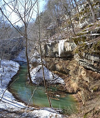
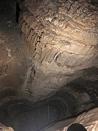
Cedar Sink is a vertical-walled large depression, or sinkhole, in the ground, that is located in Edmonson County, Kentucky and contained within and managed by Mammoth Cave National Park. The sinkhole measures 300 feet (91.4 m) from the top sandstone plateau to the bottom of the sink and was caused by collapse of the surface soil. The landscape is karst topography, which means the region is influenced by the dissolution of soluble rocks. Sinkholes, caves, and dolines typically characterize these underground drainage systems. Cedar Sink has a bottom area of about 7 acres (2.8 ha) and has more fertile soil compared to the ridgetops.
The Pope Mega Group is a geologic unit found in the Illinois Basin of southern Illinois, southwestern Indiana, and western Kentucky. In Indiana and Kentucky its equitant is the Buffalo Wallow Group. This unit grades from sandstones at its base into mix of limestones and sandstone and then a shale at its top. In Southern Illinois oil wells are drilled into the Tar Springs formation.