
Cambridgeshire is a county in the East of England, bordering Lincolnshire to the north, Norfolk to the north-east, Suffolk to the east, Essex and Hertfordshire to the south, and Bedfordshire and Northamptonshire to the west. The city of Cambridge is the county town. Modern Cambridgeshire was formed in 1974 through the amalgamation of two administrative counties: Cambridgeshire and Isle of Ely, comprising the historic county of Cambridgeshire ; and Huntingdon and Peterborough, comprising the historic county of Huntingdonshire and the Soke of Peterborough, historically part of Northamptonshire. Cambridgeshire contains most of the region known as Silicon Fen.
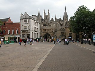
Peterborough is a cathedral city and unitary authority area in Cambridgeshire, England, with a population of 202,110 in 2017. Historically part of Northamptonshire, it is 76 miles (122 km) north of London, on the River Nene which flows into the North Sea 30 miles (48 km) to the north-east. The railway station is an important stop on the East Coast Main Line between London and Edinburgh. Peterborough is also the largest city in the East Anglia area of England.

Cambridge is a university city and the county town of Cambridgeshire, England, on the River Cam approximately 55 miles (89 km) north of London. At the United Kingdom Census 2011, the population of the Cambridge built-up area was 158,434 including 29,327 students. Cambridge became an important trading centre during the Roman and Viking ages, and there is archaeological evidence of settlement in the area as early as the Bronze Age. The first town charters were granted in the 12th century, although modern city status was not officially conferred until 1951.

East Anglia is a geographical area in the East of England. The area included has varied but the legally defined NUTS 2 statistical unit comprises the counties of Norfolk, Suffolk and Cambridgeshire, including the City of Peterborough unitary authority area. The name derives from the Anglo-Saxon kingdom of the East Angles, a tribe whose name originated in Anglia, in what is now northern Germany.

The East of England is one of the nine official regions of England. This region was created in 1994 and was adopted for statistics purposes from 1999. It includes the ceremonial counties of Bedfordshire, Cambridgeshire, Essex, Hertfordshire, Norfolk and Suffolk. Essex has the highest population in the region.
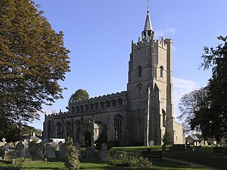
Burwell is a village and civil parish in Cambridgeshire, England, some 10 miles north-east of Cambridge. It lies on the south-east edge of the Fens. Westward drainage is improved by Cambridgeshire lodes (waterways), including Burwell Lode, a growth factor in the village. A population of 6,309 in the 2011 census was put at 6,417 in 2019.
Danbury is a village in the City of Chelmsford, in the county of Essex, England. It is located 33.5 miles (53.9 km) northeast of Charing Cross, London and has a population of 6,500. It is situated on a hill 367 feet (112 m) above sea level.
Girlguiding London and South East England is one of the nine Regions and Countries of Girlguiding. Region HQ is in Wandsworth Common, London. The Chief Commissioner is currently Sally Christmas.
Scouting in South East England provides an overview of Scouting activities in the governmental region of South East England. The largest number of Scouts and volunteer leaders in the region is linked to the Scout Association of the United Kingdom, while there is also a presence of traditional Scouting groups, such as the Baden-Powell Scouts' Association. The Scout Association administers the region through 9 Scout Counties, overseen by a regional commissioner, which follow the boundaries of the ceremonial counties they exist within. There are also a number of Scouting clubs within Universities in the region which are affiliated to the Student Scout and Guide Organisation.
Girlguiding North East England is one of the nine Regions and Countries of Girlguiding UK. The regional office is in Huntington, near York.

Castle Camps is a village and civil parish in the South Cambridgeshire district, in the county of Cambridgeshire, England. It is 15 miles (24 km) south-east of Cambridge and near to the borders of Suffolk and Essex and to the town of Haverhill. The population of the parish was 684 at the 2011 Census.

Girlguiding Scotland is part of the worldwide Guiding movement. It is the country's largest voluntary organisation for girls and young women with 61,375 members in 3,500 units throughout Scotland.

Scouting in South West England is about Scouting activities in the governmental region of South West England. The largest number of Scouts, volunteer leaders and groups are members of the Scout Association of the United Kingdom while there are some traditional Scouting groups such as the Baden-Powell Scouts' Association. The Scout Association administers the region through 7 Scout Counties, overseen by a regional commissioner, which follow the boundaries of the ceremonial counties they exist within. There are six active student associations at various universities in the region, each of which is affiliated to the Student Scout and Guide Organisation (SSAGO).

Scouting in East of England is about Scouting in the official region of East of England. It is largely represented by The Scout Association of the United Kingdom and some Groups of traditional Scouting including the Baden-Powell Scouts' Association.

Little Thetford is a small village in the civil parish of Thetford, 3 miles (5 km) south of Ely in Cambridgeshire, England, about 76 miles (122 km) by road from London. The village is built on a boulder clay island surrounded by flat fenland countryside, typical of settlements in this part of the East of England. During the Mesolithic era, the fenland basin was mostly dry and forested, although subject to salt and fresh water incursions. The marshes and meres of this fenland may therefore have been difficult to occupy, other than seasonally, but there is evidence of human settlement on the island since the late Neolithic Age; a Bronze Age causeway linked the village with the nearby Barway, to the south-east. An investigation, prior to a 1995 development in the village, discovered a farm and large tile-kiln of Romano-British origin; further investigations uncovered an earlier settlement of the Pre-Roman Iron Age. The Roman road Akeman Street passed through the north-west corner of the parish, and the lost 7th century Anglo-Saxon village of Cratendune may be nearby.
Girlguiding North West England is one of the nine Countries and Regions of Girlguiding UK. It is further subdivided into 17 Girlguiding Counties. These are not the same as the counties defined by the British government. The region was introduced in 1960 covering the Counties of Cumberland, Westmorland, Cheshire, Lancashire, plus the Isle of Man, with the headquarters in Preston. It is also known, for example to the Charity Commissioners, as the Guide Association North West England.

Great Totham is a village and civil parish in Maldon district, Essex, England, and midway between Chelmsford and Colchester. The village includes the Island of Osea in the Blackwater estuary and is separated into two parts, north and south. The north side and the south side are about a mile and a half apart, distributed along the B1022. The parish contains the hamlet of Totham Hill.

Cambridge is a university town and the administrative centre of the county of Cambridgeshire, England. It lies in East Anglia about 50 miles (80 km) north of London. Its main transport links are the M11 road to London, the A14 east–west road and the West Anglia Main Line railway line to London.

Essex is a county in the East of England, north-east of London. One of the home counties, it borders Suffolk and Cambridgeshire to the north, Hertfordshire to the west, Kent across the estuary of the River Thames to the south and London to the south-west. The county town is Chelmsford, the only city in the county. For the purposes of government statistics, Essex is placed in the East of England region.

Heart East is a regional radio station owned and operated by Global as part of the Heart network. It broadcasts to the East of England from studios in Milton Keynes.
 Hautbois House
 Training and Dining Room Extension in 2007
