Githurai | |
---|---|
Suburb | |
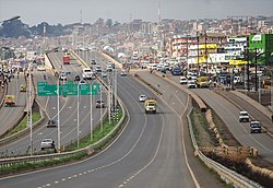
![]() Githurai viewed from Thika road. | |
Nickname: Githu | |
Country | ![]() |
County | Nairobi County & Kiambu County |
Sub-counties | Kasarani & Githurai |
Area | |
• Total | 25.5 km2 (9.8 sq mi) |
Population (2019) [1] | |
• Total | 262,327 |
• Density | 17,477/km2 (45,270/sq mi) |
Population in Githurai sub-locations in Nairobi and Kiambu counties | |
Time zone | UTC+3 (EAT) |
Githurai is a composition of densely populated, urban, mixed-use settlements located at the border of Nairobi County and Kiambu County along the Thika Road. Githurai is divided into two; Githurai 45 (also known as Githurai Kimbo) and Githurai 44. Githurai 45 falls under Ruiru Municipality in the Githurai Sub-county of Kiambu County with the boundary being the Thika Road reserve and River Kasarani (also known as River Gathara-ini) downstream. Githurai 44 is domiciled in the Kasarani Sub-county of Nairobi County. Githurai 44 neighbours Kahawa West, Zimmerman and Njatha-ini Village.
Githurai is home to St Lucie Kiriri Girls High School and Kiriri Women's University of Science and Technology [2] Lily Academy and St. Kizito Vocational Training Institute. [3] [4] Githurai is served by the Thika Road Super Highway and a branch of the Kenya-Uganda Railway from Nairobi to Thika via Ruiru. There exists a Kenya Army Amoury belonging to the Kahawa Garrison/Barracks in Githurai Kimbo. A Githurai Shopping Centre exists. [5] Githurai Community Clinic is near, but not in Githurai. [6] Other residential areas in the Nairobi include Kahawa, Kasarani, Dandora, Ongata Rongai and Ruai. [7] Githurai is extremely urban and heavily dominated by the Kikuyu tribe who are proficient in businesses. The presence of multiple campuses in the vicinity of the town has also increased the population exponentially.
Githurai is widely regarded as the "gateway" to the Mount Kenya political bedrock. Politicians looking to cement their presence in the vote-rich mountain region often use the Githurai area as a launching pad of their politics. [8] [9]
Thika is an industrial town and commerce hub in Kiambu County, Kenya, lying on the A2 road 42 kilometres (26 mi), northeast of Nairobi, near the confluence of the Thika and Chania Rivers. Although Thika town is administratively in Kiambu County, the greater Thika area comprising residential areas such as Bendor estate, Maporomoko, Thika Greens, Thika Golden Pearl, Bahati Ridge, and Thika Sports Club, among others, are within Murang'a County. Thika had a population of 279,429 as of the 2019 National Census and is growing rapidly. Its elevation is approximately 1,631 metres (5,351 ft).
Ruiru is a municipality and sub-county in Kiambu County, Kenya. It sits within the greater Nairobi Metropolitan region. According to the 2019 national population census, Ruiru was the 4th largest urban centre in Kenya by population. The name Ruiru is of the Kikuyu origin and possibly relates to the black cotton soil that is found in most parts of Ruiru.
Kiambu County is a county in the former Central Province of Kenya. Its capital is Kiambu and its largest town is Thika town. Kiambu County is the second most populous county in Kenya after Nairobi County. Kiambu County borders Nairobi and Kajiado Counties to the South, Machakos to the East, Murang'a to the North and North East, Nyandarua to the North West, and Nakuru to the West. It has a population of 2,417,735.
Gatundu is a small town in Kiambu County of Kenya. It is known for the first Kenyan president Jomo Kenyatta who lived about three kilometres away from the town, as well as his son, Uhuru Kenyatta, the 4th President of Kenya and former Member of Parliament representing Gatundu South Constituency. The town is located on a hill surrounded by many farms and residences.
Railway stations in Kenya include:
Kahawa is a mixed-use settlement spanning the Kiambu and Nairobi county borders along Thika Road. It is electorally divided into four wards across the two counties: Kahawa and Kahawa West wards in Nairobi county and Kahawa Wendani and Kahawa Sukari wards in Kiambu county. Despite its proximity to the city, half of it is administratively in Ruiru, while some parts, such as Kenyatta University, Kahawa Barracks, Kiwanja and Githurai 44, are administratively in Kasarani.
Ongata Rongai is a town located in Kajiado North, Kajiado County, Kenya. The town is situated 17 km (10.6 mi) south of the Nairobi CBD, East of the Ngong hills, and within the greater Nairobi Metropolitan Region. It lies 1,731 meters (5,682 feet) above sea level. According to the 2019 Census, it is the most populous town in Kajiado County and eleventh largest urban centre by population in Kenya.
Kingdom Bank Limited (Kenya), formerly Jamii Bora Bank, is a commercial bank in Kenya. It is one of the commercial banks licensed by the Central Bank of Kenya, the national banking regulator.
Kasarani is a mixed-use neighbourhood in northeast Nairobi. Kasarani is also used in reference to the city's second most populated sub-county with the same name, encompasing various neighbourhoods in the northeastern areas of Nairobi. Located within the larger Kasarani area, the Kasarani enclave is approximately 11 kilometres (7 mi) northeast of Nairobi's central business district off Thika Road.
Juja is a town in Kiambu County in Kenya. It is the home town of Jomo Kenyatta University of Agriculture and Technology (JKUAT).
Membley Estate is an upper middle-class suburb located near Nairobi, in the South-Western Ruiru Municipal area of Kiambu County. The suburb is located a short distance from Kenyatta University, Kamakis and Tatu City some 1.5 Kilometers from the Thika Road. The Membley Baptist, St. Lucia Catholic Church and ACK St Mathew's Membley Churches are found within this locality.
Unaitas Sacco Society Limited, whose full name is Unaitas Savings & Credit Cooperative Society Limited, also Unaitas Sacco, is a savings and credit co-operative society (Sacco) in Kenya. Membership includes individuals, investment groups and small businesses.
Roysambu Constituency is an electoral constituency in Nairobi. It is one of seventeen constituencies in Nairobi City County. It was created prior to the 2013 general election, when Kasarani Constituency was divided into three constituencies: Kasarani, Roysambu and Ruaraka.
Lizzie Mūthoni Wanyoike was a Kenyan businesswoman, educator, and philanthropist, who was the founder and chief executive officer of the Nairobi Institute of Business Studies (NIBS).
Nairobi Northern Bypass Highway is a road in Kenya, the largest economy in the East African Community. It connects the neighbourhood of Ruaka to the neighborhood of Ruiru, both in Kiambu County.
Tatu City is a 5,000 acres (2,000 ha) special economic zone (SEZ) located 20 kilometres (12 mi) North of Nairobi Central Business District (CBD) in the Ruiru Municipality area of Kiambu County. It sits within the greater Nairobi Metropolitan region and is a flagship project of the Kenya Vision 2030 blueprint. Investors currently on record include the Njiiri School Alumni, with 35% shareholding. The current Kiambu County Governor, Wamatangi is currently engaged with its management to grab over 200 hectares of the private property. Wamatangi is currently on Interpol's Most Wanted radar on allegations of fraud.
Roysambu is a commercial and residential suburb of the city of Nairobi. Located within the larger Kasarani area, it is approximately 11 kilometres (7 mi) northeast of Nairobi's central business district off Thika Road. The neighbourhood is a high-density, hosting the lower middle income to low income segment of the Nairobi residents.
Mwiki is a low-income neighbourhood in the counties of Nairobi and Kiambu. It is approximately 14 kilometres (8.7 mi) northeast of the central business district of Nairobi. Due to its transregional nature, the part of Mwiki that is within Nairobi is referred as Kasarani Mwiki while the other portion domiciled in Kiambu is referred as Githurai Mwiki.