
The Brienzer Rothorn is a mountain of the Emmental Alps, in Switzerland. With an elevation of 2,350 metres (7,710 ft) above sea level, the Brienzer Rothorn is the highest summit of the range. To its west lies the Tannhorn, whilst to its east are Arnihaaggen, Höch Gumme and the Brünig Pass. On its south side it overlooks Lake Brienz, whilst to the north it looks out over the Waldemme valley.

Nufenen Pass is the second highest mountain pass with a paved road in Switzerland, with an elevation of 2,478 metres. It lies between the summits of Pizzo Gallina (north) and the Nufenenstock (south). The road opened to motor vehicle traffic in September 1969.

Lukmanier Pass is a pass in the Swiss Alps.
The Flüela Pass is a high mountain pass of the Swiss Alps in Graubünden. Traditionally considered the boundary between the Albula and Silvretta Alps, the pass crosses the watershed / drainage divide between the basins of the rivers Rhine and Danube. The pass is overlooked by the Flüela Schwarzhorn and the Flüela Wisshorn. The summit of the pass lies between the lakes Lai da la Scotta and Lai Nair.

Fuorn Pass or Ofen Pass is a high alpine mountain pass in the canton of Graubünden in Switzerland. The name is based on the ovens that were used in ironworks in the area. The ruins of these ovens can still be seen from nearby trails.

Furka Pass is a 2,429 m (7,969 ft) high mountain pass in the southern Swiss Alps connecting Gletsch, Valais with Realp, Uri via the seasonal Furkapassroute. The Furka Oberalp Bahn bypasses the pass through the 1,390 m (4,560 ft) high Furka Base Tunnel, which opened in 1982 to replace the seasonal Furka Summit Tunnel at 2,160 metres (7,090 ft).

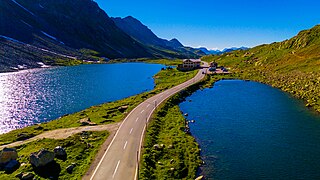
Umbrail Pass is a high mountain pass on the Swiss-Italian border connecting Santa Maria in Val Müstair with Bormio in the Adda valley. On the Italian side, it connects to the Stelvio Pass road and the Valtellina. It is currently the highest paved road in Switzerland.

Pragel Pass is a high mountain pass in the Swiss Alps between the cantons of Schwyz and Glarus between Muotathal and Netstal. The pass itself is located in the canton of Schwyz.

Susten Pass is a mountain pass in the Swiss Alps. The pass road, built from 1938–1945, connects Innertkirchen in the canton of Bern with Wassen in the canton of Uri. A 300-metre long tunnel crosses the pass at 2,224 metres.

Col des Montets is a mountain pass in the French Alps in the Haute-Savoie department of France. It is on the road between Chamonix, the Swiss Col de la Forclaz and Martigny in the canton of Valais, Switzerland.

Col de la Givrine is a high mountain pass in the Jura Mountains in the canton of Vaud in Switzerland, near the border with France.

Col du Marchairuz is a high mountain pass in the Jura Mountains in the canton of Vaud in Switzerland.

Livigno Pass or Forcola di Livigno Pass is a high mountain pass in the Alps on the border between the canton of Graubünden in Switzerland and the Province of Sondrio in Italy.
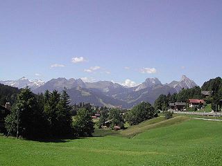
Saanenmöser is a high mountain pass in the Bernese Oberland in the Alps in Switzerland.
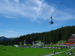
Schwägalp Pass is a high mountain pass in the Alps between the cantons of St. Gallen and Appenzell Ausserrhoden in Switzerland.

Monte Leone is the highest mountain of the Lepontine Alps and is located on the border between Switzerland and Italy. The mountain stands on the extreme west of the Lepontine Alps, a few kilometres east of Simplon Pass.

The Dammastock is the highest mountain in the Urner Alps in Switzerland and is part of the Winterberg massif. Its summit ridge forms the border between the cantons of Uri and the Valais. It is the highest summit in the canton of Uri. The tripoint between the cantons of Bern, Valais and Uri lies near the Eggstock, north of the Dammastock. Politically, the Dammastock is split between the municipalities of Göschenen (Uri) and Obergoms (Valais).

Piz Medel is a mountain in the Lepontine Alps, located on the border between the cantons of Ticino and Graubünden. At 3,210 metres (10,531 ft) above sea level it is the highest summit on the chain between Lukmanier Pass and Crap la Crusch. The mountain overlooks the Greina, an important pass connecting the cantons of Graubünden and Ticino.
This page is based on this
Wikipedia article Text is available under the
CC BY-SA 4.0 license; additional terms may apply.
Images, videos and audio are available under their respective licenses.

