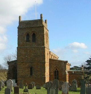
Harlestone is a village and civil parish in the West Northamptonshire district, in the ceremonial county of Northamptonshire, England. The parish had a recorded population of 445 in the 2011 census. From 1974 to 2021 it was in Daventry district.
Hanging Houghton is a small village and former civil parish, now in the parish of Lamport, in the West Northamptonshire district, in the ceremonial county of Northamptonshire, England. It is on the A508 road between Brixworth and Lamport. In 1931 the parish had a population of 84.

Weedon Lois is a village and former civil parish, now in the parish of Weston and Weedon, in the West Northamptonshire district, in the ceremonial county of Northamptonshire, England. It is about 5.5 miles (9 km) west of Towcester. In 1931 the parish had a population of 296.
Kirkby Mallory is a village and former civil parish, now in the parish of Kirkby Mallory, Peckleton and Stapleton, in the Hinckley and Bosworth district of Leicestershire, England. In 1931 the parish had a population of 231.

Morningthorpe is a village and former civil parish, now in the parish of Morningthorpe and Fritton in the South Norfolk district, in the county of Norfolk, England. It is situated some 20 kilometres (12 mi) south of the city of Norwich. The parish includes the villages of Morningthorpe and Fritton. The two villages are 1 km apart

Tarporley is a large village and civil parish in Cheshire, England. The civil parish also contains the village of Rhuddall Heath. Tarporley is bypassed by the A49 and A51 roads.

Horton is a village and former civil parish, now in the parish of Hackleton, in the West Northamptonshire district, in the ceremonial county of Northamptonshire, England. The village manor, Horton Hall, now demolished, was home to the first governor of the Bank of England and William Parr, 1st Baron Parr of Horton. An outline of its former nucleus can be seen in neighbouring fields, by its grade II park and garden which features an ornamental bridge.

Hapton is a village and former civil parish, now in the parish of Tharston and Hapton, in the South Norfolk district, in the county of Norfolk, England, located about nine miles south of Norwich. In 1931 the parish had a population of 159. On 1 April 1935 the parish was abolished and merged with Tharston.
Abington is a district of the town of Northampton and former civil parish, now in the parish of Northampton, in the West Northamptonshire district, in the ceremonial county of Northamptonshire, England, situated about 2 miles (3.2 km) east of the town centre. The population of the ward of Northampton Borough Council at the 2011 census was 9,668.

Dallington is an area and former civil parish about 1.5 miles (2.4 km) northwest of the centre of Northampton, now in the parish of Northampton, in the West Northamptonshire district, in the ceremonial county of Northamptonshire, England. Dallington was formerly a separate village. At the 2011 census the population was listed in the Spencer ward of Northampton Council.

Great Oakley is an outer suburb of Corby, in the civil parish of Corby, in the North Northamptonshire district, in the ceremonial county of Northamptonshire, England. It is situated approximately two miles south west of the town centre and five miles from Kettering. It was represented on Corby Borough Council by one councillor. The population of the Great Oakley Ward of Corby Borough Council at the 2011 Census was 2,248.

Draycot Foliat is a hamlet in the civil parish of Chiseldon, in the Swindon district, in the ceremonial county of Wiltshire, England, on the back road between Chiseldon to the north and Ogbourne St. George to the south. The nearest major town is Swindon which is about 5 miles (8 km) north. A notable feature is a small airstrip with its model helicopter instruction centre. There is one smallholding, called Draycot Farm, and a larger farm, Sheppard's Farm, which comprises some 750 acres. In addition, there are between ten and twenty other houses. The Og, a tributary of the River Kennet, flows for about half of the year down the centre of the hamlet, forcing the road into a sharp hairpin bend.

Faxton is an abandoned village in the civil parish of Lamport, in the West Northamptonshire district, in the ceremonial county of Northamptonshire in England. Nearby are the villages of Old, Lamport and Mawsley and the Northampton & Lamport Railway.

Banningham is a village and former civil parish, now in the parish of Colby, in the North Norfolk district, in the English county of Norfolk. The village is 2.9 miles north east of Aylsham, 14.7 miles north of Norwich and 129 miles north east of London. The nearest railway station is at North Walsham Railway station where the Bittern Line from Cromer to Norwich can be accessed and the national rail network beyond. The nearest airport is Norwich International Airport. The village lies a small distance east from the A140 Cromer to Norwich road. In 1931 the parish had a population of 207.

Ashwicken is a small village and former civil parish, now in the parish of Leziate, in the King's Lynn and West Norfolk district, in the county of Norfolk, England. The village sits on the B1145 King's Lynn to Mundesley road around 5 miles (8.0 km) east of King's Lynn. In 1931 the parish had a population of 117. On 1 April 1935 the parish was abolished and merged with Leziate.
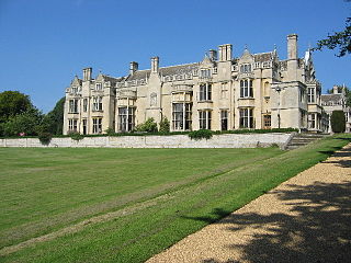
Rushton is a village and civil parish in Northamptonshire. It is about 2 miles (3.2 km) north-east of Rothwell and 3 miles (4.8 km) north-west of Kettering. The parish covers 3,200 acres (1,300 ha) and is situated on both sides of the River Ise. It contains the sites of three deserted settlements, details of which are set out below.
Warminghurst is a village and former civil parish, now in the parish of Thakeham, in the Horsham district of West Sussex, England. It lies on the Ashington to Heath Common road 2.4 miles (3.9 km) northeast of Storrington. In 1931 the parish had a population of 93. On 1 April 1933 the parish was abolished and merged with Ashington.

Preston Deanery is a village and former civil parish, now in the parish of Hackleton, in the West Northamptonshire district, in the ceremonial county of Northamptonshire, England. It is 4 miles (6 km) south of Northampton town centre and 1.5 miles (2 km) by road to the M1 London to Yorkshire motorway junction 15. It lies just off the B526 road from Northampton to Newport Pagnell, between Hackleton and Wootton, a former village which has become now a suburb of Northampton. The 2010 population estimate was 51.

Shelswell is a hamlet in the civil parish of Newton Purcell with Shelswell, in the Cherwell district, in the county of Oxfordshire, England. It is about 4 miles (6.4 km) south of Brackley in neighbouring Northamptonshire.
Penrydd is a former parish in the Hundred of Kilgerran, north Pembrokeshire, Wales. The parish's history is closely linked with that of Castellan, and included parts of the present villages of Blaenffos and Crymych.

