Related Research Articles

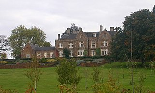
Ashby St Ledgers is a village in the West Northamptonshire district of Northamptonshire, England. The post town is Rugby in Warwickshire. The population of the civil parish at the 2011 census was 173. The Manor House is famous for being a location for the planning of the Gunpowder Plot in 1605. As of 2023, the property had been restored and could be rented for a fee.
Upper Catesby is a hamlet in the civil parish of Catesby, Northamptonshire, about 3.5 miles (5.6 km) southwest of Daventry. The hamlet is about 550 feet (170 m) above sea level, at the top of a northwest-facing escarpment. The population is included in the civil parish of Hellidon.

Staverton is a village and civil parish in the south-west of Northamptonshire, England. It is 2.3 miles west of Daventry, 7.9 miles east of Southam and 15.3 miles east of Leamington Spa. It straddles the A425 road from Daventry to Leamington. The Jurassic Way long-distance footpath between Banbury and Stamford passes through the village.

Lower Catesby is a hamlet in the civil parish of Catesby, Northamptonshire, about 4 miles (6.4 km) southwest of Daventry. Lower Catesby is beside the nascent River Leam, which rises about 1 mile (1.6 km) to the south in the parish of Hellidon. The Jurassic Way long-distance footpath passes through Lower Catesby. The population of the hamlet is included in the civil parish of Hellidon.

Dodford is a village in West Northamptonshire, England. Prior to local government changes in 2021 it was within the Weedon Ward of Daventry District. The village is just north of the A45 road 1+1⁄2 miles (2.4 km) west of Weedon. The population of the civil parish at the 2011 Census was 203. It is 3+1⁄2 miles (5.6 km) east of Daventry and 10 miles (16 km) west of Northampton. It is also close to junction 16 of the M1 motorway. The parish consists of some 1,384 acres (560 ha) and is bounded on the east by the A5 trunk road which is the old Roman road of Watling Street. Most of the village and parish sits astride the valley of an east-flowing stream which is a tributary of the River Nene.
Wolfhampcote is an abandoned village and civil parish in the English counties of Warwickshire and Northamptonshire, which it straddles. The civil parish is only in Warwickshire, with the entire eastern boundary with Northamptonshire clearly formed by the River Leam. This river also forms the boundary with Willoughby civil parish to the north.

Rainsborough Camp is an Iron Age hillfort in West Northamptonshire, England, between the villages of Croughton, Aynho, and Charlton.

Dallington is an area and former civil parish about 1.5 miles (2.4 km) northwest of the centre of Northampton, now in the parish of Northampton, in the West Northamptonshire district, in the ceremonial county of Northamptonshire, England. Dallington was formerly a separate village. At the 2011 census the population was listed in the Spencer ward of Northampton Council.

Longthorpe Tower is a 14th-century three-storey tower in the Longthorpe area of Peterborough, Cambridgeshire, England. It is famous for its well-preserved set of medieval murals.

West Northamptonshire is a unitary authority area in the ceremonial county of Northamptonshire, England, and was created in 2021. It contains the county town of Northampton, as well as Daventry, Brackley and Towcester; the rest of the area is predominantly agricultural villages though it has many lakes and small woodlands.

Althorp is a lost village within the grounds of the Althorp estate in the English county of Northamptonshire. The village is recorded in the Domesday Book. In the 15th century, the manor was held by the Catesby family who were probably responsible for clearing the settlement, for by 1505, the records show that there were no tenants. In 1508, the parish, including the cleared settlement of Althorp, was sold to John Spencer of Wormleighton in Warwickshire. By 1577, the land in the parish had been divided into four large sheep pastures. Althorp remains a civil parish.

The village of Braunston Cleves or Fawcliff formerly stood north of the village of Braunston in the English county of Northamptonshire at its border with Warwickshire. It has long been a "lost village", having no standing buildings, but its position and the topography of its street and houses can be traced from the irregularities of the ground where it formerly stood. It was on the southwest slope of Cleve's Hill within Braunston parish: it appears to have been occupied in late Anglo-Saxon and early post-Conquest times. Nothing is known of why the village was deserted but it had certainly been destroyed by the 18th century.

The lost village of Braunstonbury lies in low ground south-west of the village of Braunston in the English county of Northamptonshire. Its site is on the eastern bank of the River Leam, which also marks the border between Northamptonshire and Warwickshire. Adjacent to the site on the west side of the river Leam is the site of the lost village of Wolfhampcote which straddled the county border of both counties.

The lost village of Canons Ashby is located in ground to the north of Canons Ashby House in the English county of Northamptonshire. Today there is still a small village around the house but this is located away from the original settlement, since the original settlement is now just field occupied by a herd of cows.
Ascebi is the name of the medieval village that is the lost settlement, Canons Ashby itself is currently not lost at all and people can easily find it on any map.
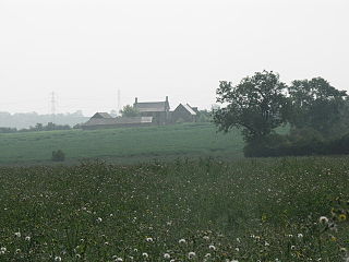
The lost village of Coton is located around the environs of the hamlet of Coton and Coton Manor House in the English county of Northamptonshire.

The lost village of Onley is in the parish of Barby in the English county of Northamptonshire. The site is bordered on the north by the M45 motorway. On the east are Onley and Rye Hill prisons, and on the south-west is the A45 road. The Oxford Canal and the disused trackbed of the Great Central Railway run close to the eastern boundary.

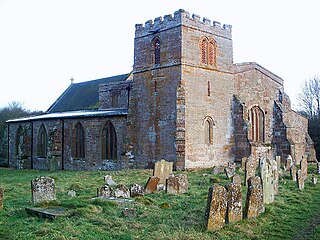
The lost village of Church Charwelton lies south-east of the village of Charwelton in the English county of Northamptonshire. Its site is on the north-east bank of the River Cherwell. The Jurassic Way long-distance footpath passes across the site.
The deserted village of Wythmail is located 4.5 miles south of Kettering in the English county of Northamptonshire. The village of Orlingbury is 1.1 miles to the east. Wythmail was part of the parish of Orlingbury.
References
- ↑ An Inventory of Archaeological Sites in North-West Northamptonshire (1981) HMSO, ISBN 0-11-700900-8
- ↑ An Inventory of Archaeological Sites in Central Northamptonshire (1979) HMSO, ISBN 0-11-700842-7