Related Research Articles

Biogeography is the study of the distribution of species and ecosystems in geographic space and through geological time. Organisms and biological communities often vary in a regular fashion along geographic gradients of latitude, elevation, isolation and habitat area. Phytogeography is the branch of biogeography that studies the distribution of plants. Zoogeography is the branch that studies distribution of animals. Mycogeography is the branch that studies distribution of fungi, such as mushrooms.

A seamount is a large submarine landform that rises from the ocean floor without reaching the water surface, and thus is not an island, islet, or cliff-rock. Seamounts are typically formed from extinct volcanoes that rise abruptly and are usually found rising from the seafloor to 1,000–4,000 m (3,300–13,100 ft) in height. They are defined by oceanographers as independent features that rise to at least 1,000 m (3,281 ft) above the seafloor, characteristically of conical form. The peaks are often found hundreds to thousands of meters below the surface, and are therefore considered to be within the deep sea. During their evolution over geologic time, the largest seamounts may reach the sea surface where wave action erodes the summit to form a flat surface. After they have subsided and sunk below the sea surface such flat-top seamounts are called "guyots" or "tablemounts".
Kamaʻehuakanaloa Seamount is an active submarine volcano about 22 mi (35 km) off the southeast coast of the island of Hawaii. The top of the seamount is about 3,200 ft (975 m) below sea level. This seamount is on the flank of Mauna Loa, the largest active subaerial shield volcano on Earth. Kamaʻehuakanaloa is the newest volcano in the Hawaiian–Emperor seamount chain, a string of volcanoes that stretches about 3,900 mi (6,200 km) northwest of Kamaʻehuakanaloa. Unlike most active volcanoes in the Pacific Ocean that make up the active plate margins on the Pacific Ring of Fire, Kamaʻehuakanaloa and the other volcanoes of the Hawaiian–Emperor seamount chain are hotspot volcanoes and formed well away from the nearest plate boundary. Volcanoes in the Hawaiian Islands arise from the Hawaii hotspot, and as the youngest volcano in the chain, Kamaʻehuakanaloa is the only Hawaiian volcano in the deep submarine preshield stage of development.

The benthic zone is the ecological region at the lowest level of a body of water such as an ocean, lake, or stream, including the sediment surface and some sub-surface layers. The name comes from the Ancient Greek word βένθος (bénthos), meaning "the depths". Organisms living in this zone are called benthos and include microorganisms as well as larger invertebrates, such as crustaceans and polychaetes. Organisms here generally live in close relationship with the substrate and many are permanently attached to the bottom. The benthic boundary layer, which includes the bottom layer of water and the uppermost layer of sediment directly influenced by the overlying water, is an integral part of the benthic zone, as it greatly influences the biological activity that takes place there. Examples of contact soil layers include sand bottoms, rocky outcrops, coral, and bay mud.

An abyssal plain is an underwater plain on the deep ocean floor, usually found at depths between 3,000 and 6,000 metres. Lying generally between the foot of a continental rise and a mid-ocean ridge, abyssal plains cover more than 50% of the Earth's surface. They are among the flattest, smoothest, and least explored regions on Earth. Abyssal plains are key geologic elements of oceanic basins.

The seabed is the bottom of the ocean. All floors of the ocean are known as 'seabeds'.

The University of the Azores, or commonly abbreviated as UAc, is the only public university in the Autonomous Region of the Azores. It was founded on January 9, 1976, two years after the Carnation Revolution that ended several decades of dictatorship in Portugal, but before the Portuguese Third Republic was institutionalized, along with the region's autonomy. The university is a public institution dependent on the Ministry of Science, Technology and Higher Education and was established in order to advance sustainable development and higher education in the Azores.

The Lord Howe Rise is a deep sea plateau which extends from south west of New Caledonia to the Challenger Plateau, west of New Zealand in the south west of the Pacific Ocean. To its west is the Tasman Basin and to the east is the New Caledonia Basin. Lord Howe Rise has a total area of about 1,500,000 km2 (580,000 sq mi), and generally lies about 750 to 1,200 metres under water. It is part of Zealandia, a much larger continent that is now mostly submerged, and so is composed of continental crust. Some have included the 3,500 m (11,500 ft) deep New Caledonia Basin as within the rise, given its continental crust origin, and this would give a larger total area of 1,950,000 km2 (750,000 sq mi).
The Census of Marine Life was a 10-year, US $650 million scientific initiative, involving a global network of researchers in more than 80 nations, engaged to assess and explain the diversity, distribution, and abundance of life in the oceans. The world's first comprehensive Census of Marine Life — past, present, and future — was released in 2010 in London. Initially supported by funding from the Alfred P. Sloan Foundation, the project was successful in generating many times that initial investment in additional support and substantially increased the baselines of knowledge in often underexplored ocean realms, as well as engaging over 2,700 different researchers for the first time in a global collaborative community united in a common goal, and has been described as "one of the largest scientific collaborations ever conducted".
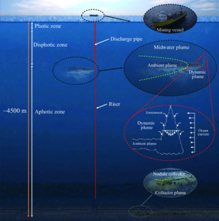
Deep sea mining is the extraction of minerals from the ocean floor at depths of 200 metres (660 ft) to 6,500 metres (21,300 ft).

Bowie Seamount, or SG̱aan Ḵinghlas in the Haida language, is a large submarine volcano in the northeastern Pacific Ocean, located 180 km (110 mi) west of Haida Gwaii, British Columbia, Canada. The seamount is also known as Bowie Bank. The English name for the feature is after William Bowie of the United States Coast and Geodetic Survey.

The following outline is provided as an overview of and introduction to Oceanography.
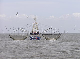
A wild fishery is a natural body of water with a sizeable free-ranging fish or other aquatic animal population that can be harvested for its commercial value. Wild fisheries can be marine (saltwater) or lacustrine/riverine (freshwater), and rely heavily on the carrying capacity of the local aquatic ecosystem.
The Future of Marine Animal Populations (FMAP) project was one of the core projects of the international Census of Marine Life (2000–2010). FMAP's mission was to describe and synthesize globally changing patterns of species abundance, distribution, and diversity, and to model the effects of fishing, climate change and other key variables on those patterns. This work was done across ocean realms and with an emphasis on understanding past changes and predicting future scenarios.

Hotspot Ecosystem Research and Man's Impact On European Seas (HERMIONE) is an international multidisciplinary project, started in April 2009, that studies deep-sea ecosystems. HERMIONE scientists study the distribution of hotspot ecosystems, how they function and how they interconnect, partially in the context of how these ecosystems are being affected by climate change and impacted by humans through overfishing, resource extraction, seabed installations and pollution. Major aims of the project are to understand how humans are affecting the deep-sea environment and to provide policy makers with accurate scientific information, enabling effective management strategies to protect deep sea ecosystems. The HERMIONE project is funded by the European Commission's Seventh Framework Programme, and is the successor to the HERMES project, which concluded in March 2009.
The Biogeography of Deep-Water Chemosynthetic Ecosystems is a field project of the Census of Marine Life programme (CoML). The main aim of ChEss is to determine the biogeography of deep-water chemosynthetic ecosystems at a global scale and to understand the processes driving these ecosystems. ChEss addresses the main questions of CoML on diversity, abundance and distribution of marine species, focusing on deep-water reducing environments such as hydrothermal vents, cold seeps, whale falls, sunken wood and areas of low oxygen that intersect with continental margins and seamounts.

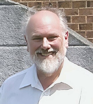
Rainer Froese is a senior scientist at the Helmholtz Center for Ocean Research (GEOMAR) in Kiel, formerly the Leibniz Institute of Marine Sciences (IFM-GEOMAR), and a Pew Fellow in Marine Conservation. He obtained an MSc in Biology in 1985 at the University of Kiel and a PhD in Biology in 1990 from the University of Hamburg. Early in his career, he worked at the Institute of Marine Sciences on computer-aided identification systems and the life strategies of fish larvae. His current research interests include fish information systems, marine biodiversity, marine biogeography, and the population dynamics of fisheries and large marine ecosystems.

The Marine Policy of the Barack Obama administration comprises several significant environmental policy decisions for the oceans made during his two terms in office from 2009 to 2017. By executive action, US President Barack Obama increased fourfold the amount of protected marine space in waters under United States control, setting a major precedent for global ocean conservation. Using the U.S. president's authority under the Antiquities Act of 1906, he expanded to 200 nautical miles the seaward limits of Papahānaumokuākea Marine National Monument in Hawaiʻi and the Pacific Remote Islands Marine National Monument around the U.S. island possessions in the Central Pacific. In the Atlantic, Obama created the Northeast Canyons and Seamounts Marine National Monument, the first marine monument in the U.S. exclusive economic zone (EEZ) in the Atlantic.
John Frederick Matthews ("Fred") Grassle was an American marine biologist, oceanographer, professor, and distinguished research scientist, notable for early work on the communities associated with deep-sea hydrothermal vents, and for his involvement in the creation of the Census of Marine Life and the first integration of marine biological data on a global scale, the Ocean Biogeographic Information System.
Kristina Maria Gjerde is a High Seas Policy Advisor for the International Union for Conservation of Nature Global Marine and Polar Program. She works on the Global Ocean Biodiversity Initiative and won the 2018 Boat International Visionary Ocean Award.
References
- 1 2 "Welcome to CenSeam: a Global Census of Marine Life on Seamounts". CenSeam. Archived from the original on 25 April 2011. Retrieved 22 July 2010.
- ↑ "Seamount". Encyclopedia of Earth. 9 December 2008. Archived from the original on 11 July 2010. Retrieved 22 July 2010.
- 1 2 "CenSeam Mission". CenSeam. Archived from the original on 24 May 2010. Retrieved 22 July 2010.
- 1 2 "CenSeam Science". CenSeam. Archived from the original on 25 April 2011. Retrieved 22 July 2010.
- 1 2 "CenSeam Project: Assessing Biodiversity Patterns on Seamounts to Identify Knowledge Gaps" (PDF). International Seabed Authority. Archived (PDF) from the original on 16 July 2011. Retrieved 28 July 2010.
- ↑ "Explorers Marvel At 'Brittlestar City' On Seamount In Powerful Current Swirling Around Antarctica". Science Daily. 18 May 2008. Archived from the original on 5 May 2010. Retrieved 28 July 2010.
- ↑ "Earth and Ocean Sciences Academic staff: Martin White, PhD". Archived from the original on 9 June 2011. Retrieved 28 July 2010.
- ↑ "Census of Marine Life on Seamounts (CenSeam)". Census of Marine Life. Archived from the original on 25 April 2011. Retrieved 28 July 2010.
- ↑ "Team CenSeam". CenSeam. Archived from the original on 22 June 2006. Retrieved 2 August 2010.